![](/images/other/stat-length.png)
![Tocht Stappen Caupenne-d'Armagnac - Caupenne d'armagnac - Photo](https://media.geolcdn.com/t/1900/400/ext.pjpeg?maxdim=2&url=https%3A%2F%2Fstatic1.geolcdn.com%2Fsiteimages%2Fupload%2Ffiles%2F1553511878bg_sport_marche.png)
Caupenne d'armagnac
DuMarsan
Gebruiker
![Lengte](/images/other/stat-length.png)
Lengte
12 km
![Max. hoogte](https://static1.geolcdn.com/siteimages/upload/files/1508320355ic_sort_altitude_max_24dp.png)
Max. hoogte
146 m
![Positief hoogteverschil](https://static1.geolcdn.com/siteimages/upload/files/1508320355ic_sort_den_pos_24dp.png)
Positief hoogteverschil
131 m
![Km-Effort](/images/other/stat-length.png)
Km-Effort
13,8 km
![Min. hoogte](https://static1.geolcdn.com/siteimages/upload/files/1508320355ic_sort_altitude_min_24dp.png)
Min. hoogte
84 m
![Negatief hoogteverschil](https://static1.geolcdn.com/siteimages/upload/files/1508320355ic_sort_den_neg_24dp.png)
Negatief hoogteverschil
130 m
![Boucle](https://static1.geolcdn.com/siteimages/upload/files/16400158638029165_repeat_loop_refresh_sync_direction_icon.png)
Boucle
Ja
Datum van aanmaak :
2014-12-10 00:00:00.0
Laatste wijziging :
2014-12-10 00:00:00.0
![Stappen](https://static1.geolcdn.com/sitytour/trail-icons/101.png)
2h25
Moeilijkheid : Gemakkelijk
![Scan deze QR-code om de tocht te openen in de SityTrail-applicatie](https://capi.geolives.com/qq0zvz2zws4bq2lad0pu/sitytour/trails/237627/qr.png?size=200)
Gratisgps-wandelapplicatie
Over ons
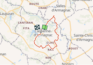
Tocht Stappen van 12 km beschikbaar op Occitanië, Gers, Caupenne-d'Armagnac. Deze tocht wordt voorgesteld door DuMarsan.
Beschrijving
Tour de Caupenne=Issu du topoguide "le pays d' armagnac à pied": rando agréable mais mal balisée ( 3 points incertains sans fléchage )rendue plus facile par ce sityguide.Carte et Gps préférables.
Plaatsbepaling
Land:
France
Regio :
Occitanië
Departement/Provincie :
Gers
Gemeente :
Caupenne-d'Armagnac
Locatie:
Unknown
Vertrek:(Dec)
Vertrek:(UTM)
735866 ; 4852573 (30T) N.
Opmerkingen
Wandeltochten in de omgeving
![Tocht Stappen Nogaro - GR 65 Nogaro > Aire sur Adour - Photo](https://media.geolcdn.com/t/375/260/a23f2d79-cf09-4340-8bb5-1bdeb60d23af.jpg&format=jpg&maxdim=2)
![Stappen Stappen](https://static1.geolcdn.com/sitytour/trail-icons/101.png)
GR 65 Nogaro > Aire sur Adour
Stappen
Moeilijk
Nogaro,
Occitanië,
Gers,
France
![](/images/other/stat-length.png)
26 km | 30 km-effort
6h 57min
![](https://static1.geolcdn.com/siteimages/upload/files/16400158638029165_repeat_loop_refresh_sync_direction_icon.png)
Neen
![Tocht Stappen Nogaro - 3 Nogaro - Photo](https://media.geolcdn.com/t/375/260/ext.jpg?maxdim=2&url=https%3A%2F%2Fstatic1.geolcdn.com%2Fsiteimages%2Fupload%2Ffiles%2F1553511878bg_sport_marche.png)
![Stappen Stappen](https://static1.geolcdn.com/sitytour/trail-icons/101.png)
![Tocht Stappen Nogaro - Camino 1 étape 25 du 20.08.2023 - Photo](https://media.geolcdn.com/t/375/260/ext.jpg?maxdim=2&url=https%3A%2F%2Fstatic1.geolcdn.com%2Fsiteimages%2Fupload%2Ffiles%2F1553511878bg_sport_marche.png)
![Stappen Stappen](https://static1.geolcdn.com/sitytour/trail-icons/101.png)
Camino 1 étape 25 du 20.08.2023
Stappen
Medium
Nogaro,
Occitanië,
Gers,
France
![](/images/other/stat-length.png)
29 km | 34 km-effort
7h 44min
![](https://static1.geolcdn.com/siteimages/upload/files/16400158638029165_repeat_loop_refresh_sync_direction_icon.png)
Neen
![Tocht Stappen Nogaro - StJ-J38-Nogaro-Aire sur l'Adour - Photo](https://media.geolcdn.com/t/375/260/ext.jpg?maxdim=2&url=https%3A%2F%2Fstatic1.geolcdn.com%2Fsiteimages%2Fupload%2Ffiles%2F1553511878bg_sport_marche.png)
![Stappen Stappen](https://static1.geolcdn.com/sitytour/trail-icons/101.png)
StJ-J38-Nogaro-Aire sur l'Adour
Stappen
Zeer moeilijk
Nogaro,
Occitanië,
Gers,
France
![](/images/other/stat-length.png)
28 km | 32 km-effort
6h 52min
![](https://static1.geolcdn.com/siteimages/upload/files/16400158638029165_repeat_loop_refresh_sync_direction_icon.png)
Neen
![Tocht Stappen Nogaro - OR-6947751--Nogaro:Nogaro-Lelin-Lapujolle-arblade le bas-7 - Photo](https://media.geolcdn.com/t/375/260/ext.jpg?maxdim=2&url=https%3A%2F%2Fstatic1.geolcdn.com%2Fsiteimages%2Fupload%2Ffiles%2F1553511878bg_sport_marche.png)
![Stappen Stappen](https://static1.geolcdn.com/sitytour/trail-icons/101.png)
OR-6947751--Nogaro:Nogaro-Lelin-Lapujolle-arblade le bas-7
Stappen
Heel gemakkelijk
(1)
Nogaro,
Occitanië,
Gers,
France
![](/images/other/stat-length.png)
21 km | 25 km-effort
5h 25min
![](https://static1.geolcdn.com/siteimages/upload/files/16400158638029165_repeat_loop_refresh_sync_direction_icon.png)
Neen
![Tocht Stappen Nogaro - Compostelle 26 - Nogaro -> Aire-sur-l'Adour - Photo](https://media.geolcdn.com/t/375/260/ext.jpg?maxdim=2&url=https%3A%2F%2Fstatic1.geolcdn.com%2Fsiteimages%2Fupload%2Ffiles%2F1553511878bg_sport_marche.png)
![Stappen Stappen](https://static1.geolcdn.com/sitytour/trail-icons/101.png)
Compostelle 26 - Nogaro -> Aire-sur-l'Adour
Stappen
Medium
Nogaro,
Occitanië,
Gers,
France
![](/images/other/stat-length.png)
29 km | 33 km-effort
7h 5min
![](https://static1.geolcdn.com/siteimages/upload/files/16400158638029165_repeat_loop_refresh_sync_direction_icon.png)
Neen
![Tocht Stappen Nogaro - Nogaro-Aire sur l'Adour - Photo](https://media.geolcdn.com/t/375/260/ext.jpg?maxdim=2&url=https%3A%2F%2Fstatic1.geolcdn.com%2Fsiteimages%2Fupload%2Ffiles%2F1553511878bg_sport_marche.png)
![Stappen Stappen](https://static1.geolcdn.com/sitytour/trail-icons/101.png)
Nogaro-Aire sur l'Adour
Stappen
Moeilijk
Nogaro,
Occitanië,
Gers,
France
![](/images/other/stat-length.png)
29 km | 34 km-effort
7h 25min
![](https://static1.geolcdn.com/siteimages/upload/files/16400158638029165_repeat_loop_refresh_sync_direction_icon.png)
Neen
![Tocht Fietstoerisme Nogaro - B - Nogaro - La route de l'Armagnac - Photo](https://media.geolcdn.com/t/375/260/ext.jpg?maxdim=2&url=https%3A%2F%2Fstatic1.geolcdn.com%2Fsiteimages%2Fupload%2Ffiles%2F1524743154velo.jpg)
![Fietstoerisme Fietstoerisme](https://static1.geolcdn.com/sitytour/trail-icons/204.png)
B - Nogaro - La route de l'Armagnac
Fietstoerisme
Medium
Nogaro,
Occitanië,
Gers,
France
![](/images/other/stat-length.png)
94 km | 109 km-effort
Onbekend
![](https://static1.geolcdn.com/siteimages/upload/files/16400158638029165_repeat_loop_refresh_sync_direction_icon.png)
Ja
![Tocht Stappen Lanne-Soubiran - presbytère-Aire sur l'Adour - Photo](https://media.geolcdn.com/t/375/260/ext.jpg?maxdim=2&url=https%3A%2F%2Fstatic1.geolcdn.com%2Fsiteimages%2Fupload%2Ffiles%2F1553511878bg_sport_marche.png)
![Stappen Stappen](https://static1.geolcdn.com/sitytour/trail-icons/101.png)
presbytère-Aire sur l'Adour
Stappen
Zeer moeilijk
Lanne-Soubiran,
Occitanië,
Gers,
France
![](/images/other/stat-length.png)
21 km | 23 km-effort
4h 46min
![](https://static1.geolcdn.com/siteimages/upload/files/16400158638029165_repeat_loop_refresh_sync_direction_icon.png)
Neen