![](/images/other/stat-length.png)
![Tocht Stappen Chastre - Promenade de l'Orne, Blanmont - Photo](https://media.geolcdn.com/t/1900/400/ext.pjpeg?maxdim=2&url=https%3A%2F%2Fservices.sitytrail.com%2FGeolivesWS%2FDownloadMedia.ashx%3FTrailID%3D236504%26Media%3D04127ce6-d82b-4795-9d9c-369fd6224f60.jpg)
Promenade de l'Orne, Blanmont
Chastre1450
Gebruiker
![Lengte](/images/other/stat-length.png)
Lengte
7,1 km
![Max. hoogte](https://static1.geolcdn.com/siteimages/upload/files/1508320355ic_sort_altitude_max_24dp.png)
Max. hoogte
152 m
![Positief hoogteverschil](https://static1.geolcdn.com/siteimages/upload/files/1508320355ic_sort_den_pos_24dp.png)
Positief hoogteverschil
94 m
![Km-Effort](/images/other/stat-length.png)
Km-Effort
8,3 km
![Min. hoogte](https://static1.geolcdn.com/siteimages/upload/files/1508320355ic_sort_altitude_min_24dp.png)
Min. hoogte
97 m
![Negatief hoogteverschil](https://static1.geolcdn.com/siteimages/upload/files/1508320355ic_sort_den_neg_24dp.png)
Negatief hoogteverschil
92 m
![Boucle](https://static1.geolcdn.com/siteimages/upload/files/16400158638029165_repeat_loop_refresh_sync_direction_icon.png)
Boucle
Ja
Datum van aanmaak :
2014-12-10 00:00:00.0
Laatste wijziging :
2014-12-10 00:00:00.0
![Stappen](https://static1.geolcdn.com/sitytour/trail-icons/101.png)
1h49
Moeilijkheid : Heel gemakkelijk
![Scan deze QR-code om de tocht te openen in de SityTrail-applicatie](https://capi.geolives.com/qq0zvz2zws4bq2lad0pu/sitytour/trails/236504/qr.png?size=200)
Gratisgps-wandelapplicatie
Over ons
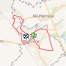
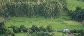
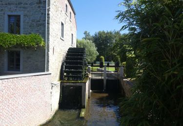
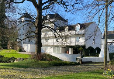
Tocht Stappen van 7,1 km beschikbaar op Wallonië, Waals-Brabant, Chastre. Deze tocht wordt voorgesteld door Chastre1450.
Beschrijving
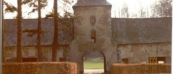
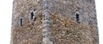
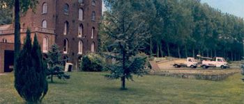
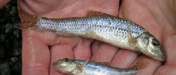
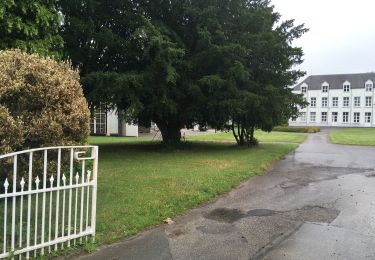
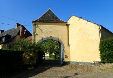
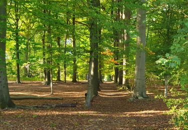
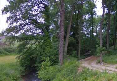
Promenade à la rencontre de moulins anciens et de la tour médiévale d'Alvaux, le long du ry du Pré à la Chambre et de l'Orne.
POI's
Plaatsbepaling
Land:
Belgium
Regio :
Wallonië
Departement/Provincie :
Waals-Brabant
Gemeente :
Chastre
Locatie:
Chastre-Villeroux-Blanmont
Vertrek:(Dec)
Vertrek:(UTM)
616002 ; 5609095 (31U) N.
Opmerkingen
Wandeltochten in de omgeving
![Tocht Stappen Ottignies-Louvain-la-Neuve - RL-GG-02 - Céroux-Mousty - Villers-la-Ville - 2025-02-08 - Photo](https://media.geolcdn.com/t/375/260/2eead39d-9522-4a6a-a4f3-f791e0a7304a.jpg&format=jpg&maxdim=2)
![Stappen Stappen](https://static1.geolcdn.com/sitytour/trail-icons/101.png)
RL-GG-02 - Céroux-Mousty - Villers-la-Ville - 2025-02-08
Stappen
Zeer moeilijk
(4)
Ottignies-Louvain-la-Neuve,
Wallonië,
Waals-Brabant,
Belgium
![](/images/other/stat-length.png)
20 km | 26 km-effort
5h 55min
![](https://static1.geolcdn.com/siteimages/upload/files/16400158638029165_repeat_loop_refresh_sync_direction_icon.png)
Neen
![Tocht Stappen Mont-Saint-Guibert - Balade à Mont-Saint-Guibert - Photo](https://media.geolcdn.com/t/375/260/ext.jpg?maxdim=2&url=https%3A%2F%2Fservices.sitytrail.com%2FGeolivesWS%2FDownloadMedia.ashx%3FTrailID%3D942864%26Media%3D4a857fe0-cf43-4eb8-b563-62b2b90d4fc2.jpg)
![Stappen Stappen](https://static1.geolcdn.com/sitytour/trail-icons/101.png)
Balade à Mont-Saint-Guibert
Stappen
Heel gemakkelijk
(2)
Mont-Saint-Guibert,
Wallonië,
Waals-Brabant,
Belgium
![](/images/other/stat-length.png)
8,4 km | 10,1 km-effort
2h 12min
![](https://static1.geolcdn.com/siteimages/upload/files/16400158638029165_repeat_loop_refresh_sync_direction_icon.png)
Ja
![Stappen Stappen](https://static1.geolcdn.com/sitytour/trail-icons/101.png)
#240223a - Blanmont, Orne, Alvaux, Nil Pierreux***
Stappen
Medium
(1)
Chastre,
Wallonië,
Waals-Brabant,
Belgium
![](/images/other/stat-length.png)
6,6 km | 7,8 km-effort
1h 47min
![](https://static1.geolcdn.com/siteimages/upload/files/16400158638029165_repeat_loop_refresh_sync_direction_icon.png)
Ja
![Tocht Stappen Chaumont-Gistoux - #231016 - Corroy-Le-Grand et le Val d'Ocquière*** (inversé court) - Photo](https://media.geolcdn.com/t/375/260/b650de28-d96e-49f2-85c2-d640aecfc352.jpg&format=jpg&maxdim=2)
![Stappen Stappen](https://static1.geolcdn.com/sitytour/trail-icons/101.png)
#231016 - Corroy-Le-Grand et le Val d'Ocquière*** (inversé court)
Stappen
Medium
(2)
Chaumont-Gistoux,
Wallonië,
Waals-Brabant,
Belgium
![](/images/other/stat-length.png)
6,2 km | 7,2 km-effort
1h 38min
![](https://static1.geolcdn.com/siteimages/upload/files/16400158638029165_repeat_loop_refresh_sync_direction_icon.png)
Ja
![Stappen Stappen](https://static1.geolcdn.com/sitytour/trail-icons/101.png)
#230728 - Gentinnes Kongolo
Stappen
Gemakkelijk
(1)
Chastre,
Wallonië,
Waals-Brabant,
Belgium
![](/images/other/stat-length.png)
5 km | 5,6 km-effort
1h 16min
![](https://static1.geolcdn.com/siteimages/upload/files/16400158638029165_repeat_loop_refresh_sync_direction_icon.png)
Ja
![Te voet Te voet](https://static1.geolcdn.com/sitytour/trail-icons/100.png)
#170829 - Nil Pierreux, carrières de quartzite, Moulin d'Al Poudre et Tour de...
Te voet
Heel gemakkelijk
(2)
Walhain,
Wallonië,
Waals-Brabant,
Belgium
![](/images/other/stat-length.png)
8,1 km | 9,9 km-effort
2h 0min
![](https://static1.geolcdn.com/siteimages/upload/files/16400158638029165_repeat_loop_refresh_sync_direction_icon.png)
Ja
![Tocht Stappen Chastre - Promenade de Villeroux - Photo](https://media.geolcdn.com/t/375/260/ext.jpg?maxdim=2&url=https%3A%2F%2Fservices.sitytrail.com%2FGeolivesWS%2FDownloadMedia.ashx%3FTrailID%3D233658%26Media%3D6ce217ee-b2e1-442a-b4a3-34a4ee262c13.JPG)
![Stappen Stappen](https://static1.geolcdn.com/sitytour/trail-icons/101.png)
Promenade de Villeroux
Stappen
Medium
(1)
Chastre,
Wallonië,
Waals-Brabant,
Belgium
![](/images/other/stat-length.png)
7,6 km | 8,5 km-effort
1h 53min
![](https://static1.geolcdn.com/siteimages/upload/files/16400158638029165_repeat_loop_refresh_sync_direction_icon.png)
Ja
![Tocht Stappen Chastre - Balade de la fontaine Saint Géry à Chastre - Photo](https://media.geolcdn.com/t/375/260/3874746a-e710-4e6b-abe9-6518786cab88.jpg&format=jpg&maxdim=2)
![Stappen Stappen](https://static1.geolcdn.com/sitytour/trail-icons/101.png)
Balade de la fontaine Saint Géry à Chastre
Stappen
Medium
(1)
Chastre,
Wallonië,
Waals-Brabant,
Belgium
![](/images/other/stat-length.png)
7,6 km | 8,6 km-effort
1h 53min
![](https://static1.geolcdn.com/siteimages/upload/files/16400158638029165_repeat_loop_refresh_sync_direction_icon.png)
Ja
![Tocht Stappen Mont-Saint-Guibert - L'Orne_Chateau de Bierbais - Photo](https://media.geolcdn.com/t/375/260/ext.jpg?maxdim=2&url=https%3A%2F%2Fservices.sitytrail.com%2FGeolivesWS%2FDownloadMedia.ashx%3FTrailID%3D181062%26Media%3Dc8d2d18f-8d77-4eaa-bbc1-c7bea14b6176.jpeg)
![Stappen Stappen](https://static1.geolcdn.com/sitytour/trail-icons/101.png)
L'Orne_Chateau de Bierbais
Stappen
Gemakkelijk
(2)
Mont-Saint-Guibert,
Wallonië,
Waals-Brabant,
Belgium
![](/images/other/stat-length.png)
9,4 km | 11,5 km-effort
2h 28min
![](https://static1.geolcdn.com/siteimages/upload/files/16400158638029165_repeat_loop_refresh_sync_direction_icon.png)
Ja