![](/images/other/stat-length.png)
![Tocht Fiets Quissac - Quissac-Quissac - Photo](https://media.geolcdn.com/t/1900/400/ext.pjpeg?maxdim=2&url=https%3A%2F%2Fstatic1.geolcdn.com%2Fsiteimages%2Fupload%2Ffiles%2F1524743154velo.jpg)
Quissac-Quissac
bqu34
Gebruiker
![Lengte](/images/other/stat-length.png)
![Max. hoogte](https://static1.geolcdn.com/siteimages/upload/files/1508320355ic_sort_altitude_max_24dp.png)
![Positief hoogteverschil](https://static1.geolcdn.com/siteimages/upload/files/1508320355ic_sort_den_pos_24dp.png)
![Km-Effort](/images/other/stat-length.png)
![Min. hoogte](https://static1.geolcdn.com/siteimages/upload/files/1508320355ic_sort_altitude_min_24dp.png)
![Negatief hoogteverschil](https://static1.geolcdn.com/siteimages/upload/files/1508320355ic_sort_den_neg_24dp.png)
![Boucle](https://static1.geolcdn.com/siteimages/upload/files/16400158638029165_repeat_loop_refresh_sync_direction_icon.png)
![Fiets](https://static1.geolcdn.com/sitytour/trail-icons/200.png)
7h32
Moeilijkheid : Heel gemakkelijk
![Scan deze QR-code om de tocht te openen in de SityTrail-applicatie](https://capi.geolives.com/qq0zvz2zws4bq2lad0pu/sitytour/trails/236474/qr.png?size=200)
Gratisgps-wandelapplicatie
Over ons
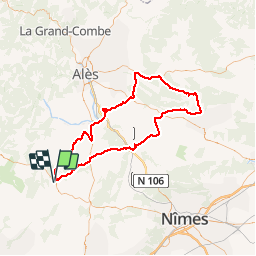
Tocht Fiets van 114 km beschikbaar op Occitanië, Gard, Quissac. Deze tocht wordt voorgesteld door bqu34.
Beschrijving
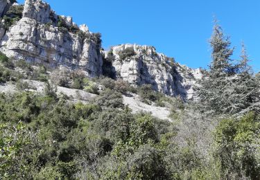
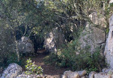
Quissac. D35. D24. Logrian (1). Puechredon. Canaules et Argentières. Saint Jean de Serres. D109. D907 vers Lédignan. premier CV à gauche. CV à gauche. Mazac. CV. Lédignan. D6110. Massanes. Vezenobres (2). D116. Saint Etienne de l’Olm. près Euzet. Saint Just. D6. Seynes.D218. Belvezet . Le Mas de la Vieille Eglise (3). D218. D979. D125. Labaume. Mas Pontier (4). Gattigues. Foissac. Collorgues. Saint Dézery. D226. Moussac (5). pont suspendu sur le Gardon. CV. La Réglisserie. Plagnol. D939. D8. Nozières. près Domessargues . D8xD124. D8. premier CV à droite. Fontaries. D724 à gauche . D907 à gauche. D215. D215b à droite. Manthes. D215b. D215bxD6110xCV en face. CV en face. CV à gauche. Savignargues. D8. D194. Saint Théodorit.Quissac.
Plaatsbepaling
Opmerkingen
Wandeltochten in de omgeving
![Tocht Stappen Quissac - Quissac - Photo](https://media.geolcdn.com/t/375/260/ext.jpg?maxdim=2&url=https%3A%2F%2Fservices.sitytrail.com%2FGeolivesWS%2FDownloadMedia.ashx%3FTrailID%3D233243%26Media%3Dfix__20131117121007.jpg)
![Stappen Stappen](https://static1.geolcdn.com/sitytour/trail-icons/101.png)
![Tocht Stappen Orthoux-Sérignac-Quilhan - Sérignac - les Mazes - Bragassargues - Photo](https://media.geolcdn.com/t/375/260/ext.jpg?maxdim=2&url=https%3A%2F%2Fstatic1.geolcdn.com%2Fsiteimages%2Fupload%2Ffiles%2F1553511878bg_sport_marche.png)
![Stappen Stappen](https://static1.geolcdn.com/sitytour/trail-icons/101.png)
Stappen
![](/images/other/stat-length.png)
![](https://static1.geolcdn.com/siteimages/upload/files/16400158638029165_repeat_loop_refresh_sync_direction_icon.png)
![Tocht Te voet Liouc - Les chênes de Coutach - Photo](https://media.geolcdn.com/t/375/260/cf45b531-3715-4133-ba5a-b053d48b9be2.jpeg&format=jpg&maxdim=2)
![Te voet Te voet](https://static1.geolcdn.com/sitytour/trail-icons/100.png)
Te voet
![](/images/other/stat-length.png)
![](https://static1.geolcdn.com/siteimages/upload/files/16400158638029165_repeat_loop_refresh_sync_direction_icon.png)
![Tocht Paardrijden Orthoux-Sérignac-Quilhan - mas bas - corconnes en boucle - Photo](https://media.geolcdn.com/t/375/260/debc9152-3802-423a-8c6a-1db256dabcad.jpg&format=jpg&maxdim=2)
![Paardrijden Paardrijden](https://static1.geolcdn.com/sitytour/trail-icons/301.png)
Paardrijden
![](/images/other/stat-length.png)
![](https://static1.geolcdn.com/siteimages/upload/files/16400158638029165_repeat_loop_refresh_sync_direction_icon.png)
![Tocht Stappen Corconne - 30 corconne - Photo](https://media.geolcdn.com/t/375/260/935d2ba4-5725-4112-bf5b-aad99ed037b4.jpg&format=jpg&maxdim=2)
![Stappen Stappen](https://static1.geolcdn.com/sitytour/trail-icons/101.png)
Stappen
![](/images/other/stat-length.png)
![](https://static1.geolcdn.com/siteimages/upload/files/16400158638029165_repeat_loop_refresh_sync_direction_icon.png)
![Tocht Stappen Sauve - Sauve, le sentier de l'Aven - Photo](https://media.geolcdn.com/t/375/260/ext.jpg?maxdim=2&url=https%3A%2F%2Fstatic1.geolcdn.com%2Fsiteimages%2Fupload%2Ffiles%2F1553511878bg_sport_marche.png)
![Stappen Stappen](https://static1.geolcdn.com/sitytour/trail-icons/101.png)
Stappen
![](/images/other/stat-length.png)
![](https://static1.geolcdn.com/siteimages/upload/files/16400158638029165_repeat_loop_refresh_sync_direction_icon.png)
![Tocht Stappen Corconne - Corconne - Photo](https://media.geolcdn.com/t/375/260/ext.jpg?maxdim=2&url=https%3A%2F%2Fstatic1.geolcdn.com%2Fsiteimages%2Fupload%2Ffiles%2F1553511878bg_sport_marche.png)
![Stappen Stappen](https://static1.geolcdn.com/sitytour/trail-icons/101.png)
Stappen
![](/images/other/stat-length.png)
![](https://static1.geolcdn.com/siteimages/upload/files/16400158638029165_repeat_loop_refresh_sync_direction_icon.png)
![Tocht Stappen Corconne - CORCONNE - Photo](https://media.geolcdn.com/t/375/260/cec47011-04b4-4f0a-b521-d4e592fe1993.jpg&format=jpg&maxdim=2)
![Stappen Stappen](https://static1.geolcdn.com/sitytour/trail-icons/101.png)
![Tocht Stappen Corconne - 30 le mazet des gardes Corconne 8/11/23 - Photo](https://media.geolcdn.com/t/375/260/b14cbd76-fce3-469c-9994-e0217aa95e9f.jpg&format=jpg&maxdim=2)
![Stappen Stappen](https://static1.geolcdn.com/sitytour/trail-icons/101.png)
Stappen
![](/images/other/stat-length.png)
![](https://static1.geolcdn.com/siteimages/upload/files/16400158638029165_repeat_loop_refresh_sync_direction_icon.png)