![](/images/other/stat-length.png)
![Tocht Stappen Avignon - AVIGNON Île de la Barthelasse - Photo](https://media.geolcdn.com/t/1900/400/ext.pjpeg?maxdim=2&url=https%3A%2F%2Fstatic1.geolcdn.com%2Fsiteimages%2Fupload%2Ffiles%2F1553511878bg_sport_marche.png)
AVIGNON Île de la Barthelasse
Manoune
Gebruiker
![Lengte](/images/other/stat-length.png)
![Max. hoogte](https://static1.geolcdn.com/siteimages/upload/files/1508320355ic_sort_altitude_max_24dp.png)
![Positief hoogteverschil](https://static1.geolcdn.com/siteimages/upload/files/1508320355ic_sort_den_pos_24dp.png)
![Km-Effort](/images/other/stat-length.png)
![Min. hoogte](https://static1.geolcdn.com/siteimages/upload/files/1508320355ic_sort_altitude_min_24dp.png)
![Negatief hoogteverschil](https://static1.geolcdn.com/siteimages/upload/files/1508320355ic_sort_den_neg_24dp.png)
![Boucle](https://static1.geolcdn.com/siteimages/upload/files/16400158638029165_repeat_loop_refresh_sync_direction_icon.png)
![Stappen](https://static1.geolcdn.com/sitytour/trail-icons/101.png)
4h26
Moeilijkheid : Gemakkelijk
![Scan deze QR-code om de tocht te openen in de SityTrail-applicatie](https://capi.geolives.com/qq0zvz2zws4bq2lad0pu/sitytour/trails/2346908/qr.png?size=200)
Gratisgps-wandelapplicatie
Over ons
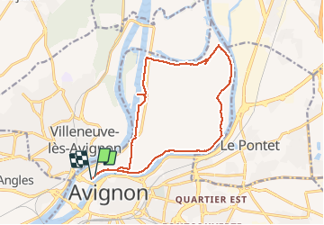
Tocht Stappen van 16,3 km beschikbaar op Provence-Alpes-Côte d'Azur, Vaucluse, Avignon. Deze tocht wordt voorgesteld door Manoune.
Beschrijving
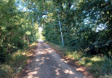
Départ parking Bagatelle, suivre le le bord du Rhône, Halte Fluviale, la Projette, Château de la Barthelasse, la Grande Bastide, Laurent, les Cabanes, ( attention depuis notre passage du 29:12:19, nous avons trouvé des barrières sur le passage du chemin, nous les avons contourné , des panneaux nous indiquent propriété privée) voir s'il est possible de contourner les Cabanes) ensuite la Merveille, face à la cascade de l'Ouvèze. Suivre le bras mort du Rhône jusqu'au Parc des Libertés, traversée de la D 228 et suivre le canal jusqu'à l'écluse d'Avignon et retour au parking.
Plaatsbepaling
Opmerkingen
Wandeltochten in de omgeving
![Tocht Stappen Avignon - ile de la Barthelasse - Photo](https://media.geolcdn.com/t/375/260/e0f4fcd0-18e6-4d74-a6c3-369037188a72.jpg&format=jpg&maxdim=2)
![Stappen Stappen](https://static1.geolcdn.com/sitytour/trail-icons/101.png)
Stappen
![](/images/other/stat-length.png)
![](https://static1.geolcdn.com/siteimages/upload/files/16400158638029165_repeat_loop_refresh_sync_direction_icon.png)
![Tocht Stappen Avignon - ile de Barthelasse 1ere du top 10 des balades d Avignon... pauvres avignonais... - Photo](https://media.geolcdn.com/t/375/260/963c3ee6-7875-4ee3-ace7-cd7418306cf7.jpg&format=jpg&maxdim=2)
![Stappen Stappen](https://static1.geolcdn.com/sitytour/trail-icons/101.png)
Stappen
![](/images/other/stat-length.png)
![](https://static1.geolcdn.com/siteimages/upload/files/16400158638029165_repeat_loop_refresh_sync_direction_icon.png)
![Stappen Stappen](https://static1.geolcdn.com/sitytour/trail-icons/101.png)
Stappen
![](/images/other/stat-length.png)
![](https://static1.geolcdn.com/siteimages/upload/files/16400158638029165_repeat_loop_refresh_sync_direction_icon.png)
![Tocht Stappen Avignon - 2024-08-24 Barthelasse - grand bosquet - Photo](https://media.geolcdn.com/t/375/260/ad341062-73ba-4d71-afc7-9fafb7f4736e.jpg&format=jpg&maxdim=2)
![Stappen Stappen](https://static1.geolcdn.com/sitytour/trail-icons/101.png)
Stappen
![](/images/other/stat-length.png)
![](https://static1.geolcdn.com/siteimages/upload/files/16400158638029165_repeat_loop_refresh_sync_direction_icon.png)
![Tocht Lopen Le Pontet - Le Pontet - Photo](https://media.geolcdn.com/t/375/260/12075d35-a7fc-4605-a13a-ec9078e8b636.jpg&format=jpg&maxdim=2)
![Lopen Lopen](https://static1.geolcdn.com/sitytour/trail-icons/103.png)
Lopen
![](/images/other/stat-length.png)
![](https://static1.geolcdn.com/siteimages/upload/files/16400158638029165_repeat_loop_refresh_sync_direction_icon.png)
![Tocht Stappen Avignon - baguenaudage en Avignon - Photo](https://media.geolcdn.com/t/375/260/307f00c2-1f87-43b1-84c1-7a62203d52aa.jpg&format=jpg&maxdim=2)
![Stappen Stappen](https://static1.geolcdn.com/sitytour/trail-icons/101.png)
Stappen
![](/images/other/stat-length.png)
![](https://static1.geolcdn.com/siteimages/upload/files/16400158638029165_repeat_loop_refresh_sync_direction_icon.png)
![Tocht Te voet Avignon - Canal du Puy - 1 - Photo](https://media.geolcdn.com/t/375/260/f4209b10-1fc5-4574-92df-51fcf3ed9802.jpeg&format=jpg&maxdim=2)
![Te voet Te voet](https://static1.geolcdn.com/sitytour/trail-icons/100.png)
Te voet
![](/images/other/stat-length.png)
![](https://static1.geolcdn.com/siteimages/upload/files/16400158638029165_repeat_loop_refresh_sync_direction_icon.png)
![Tocht Lopen Avignon - running hopital - Photo](https://media.geolcdn.com/t/375/260/ext.jpg?maxdim=2&url=https%3A%2F%2Fstatic1.geolcdn.com%2Fsiteimages%2Fupload%2Ffiles%2F1524743154running.jpg)
![Lopen Lopen](https://static1.geolcdn.com/sitytour/trail-icons/103.png)
Lopen
![](/images/other/stat-length.png)
![](https://static1.geolcdn.com/siteimages/upload/files/16400158638029165_repeat_loop_refresh_sync_direction_icon.png)
![Tocht Fietstoerisme Les Angles - Avant dernière étape - Photo](https://media.geolcdn.com/t/375/260/77ee41c0-83af-4a4a-a427-853d84ab2441.jpg&format=jpg&maxdim=2)
![Fietstoerisme Fietstoerisme](https://static1.geolcdn.com/sitytour/trail-icons/204.png)
Fietstoerisme
![](/images/other/stat-length.png)
![](https://static1.geolcdn.com/siteimages/upload/files/16400158638029165_repeat_loop_refresh_sync_direction_icon.png)