
Chapelle Saint Christau à Accous

bedous
Gebruiker

Lengte
3,6 km

Max. hoogte
836 m

Positief hoogteverschil
146 m

Km-Effort
5,6 km

Min. hoogte
697 m

Negatief hoogteverschil
147 m
Boucle
Ja
Datum van aanmaak :
2020-02-23 13:36:51.274
Laatste wijziging :
2020-02-23 18:14:29.253
1h29
Moeilijkheid : Gemakkelijk

Gratisgps-wandelapplicatie
Over ons
Tocht Stappen van 3,6 km beschikbaar op Nieuw-Aquitanië, Pyrénées-Atlantiques, Accous. Deze tocht wordt voorgesteld door bedous.
Beschrijving
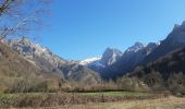
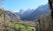
Boucle au départ de la chapelle, descente jusqu'au gave La Berthe que l'on suit au travers d'un pâturage pour rejoindre un chemin boisé et remonter par la route bitumée. Magnifique vue sur le cirque d'Accous.
Plaatsbepaling
Land:
France
Regio :
Nieuw-Aquitanië
Departement/Provincie :
Pyrénées-Atlantiques
Gemeente :
Accous
Locatie:
Unknown
Vertrek:(Dec)
Vertrek:(UTM)
698199 ; 4760670 (30T) N.
Opmerkingen
Wandeltochten in de omgeving
ACCOUS Chapelle San Christau "2805437"


Stappen
Gemakkelijk
(1)
Accous,
Nieuw-Aquitanië,
Pyrénées-Atlantiques,
France

8,8 km | 14,3 km-effort
2h 44min
Ja
Le Tour de Saudious


Stappen
Medium
(1)
Bedous,
Nieuw-Aquitanië,
Pyrénées-Atlantiques,
France

6 km | 8,7 km-effort
1h 30min
Ja
BEDOUS le tour du Pouey autrement "4119701"


Stappen
Moeilijk
Bedous,
Nieuw-Aquitanië,
Pyrénées-Atlantiques,
France

9 km | 13,4 km-effort
3h 2min
Ja
BEDOUS les chemins du gaves G4 "4014081"


Te voet
Gemakkelijk
Bedous,
Nieuw-Aquitanië,
Pyrénées-Atlantiques,
France

11,2 km | 12,9 km-effort
2h 55min
Ja
BEDOUS Le tour du Bugala par Osse en Aspe


Te voet
Gemakkelijk
Bedous,
Nieuw-Aquitanië,
Pyrénées-Atlantiques,
France

11,6 km | 16,8 km-effort
3h 56min
Ja
Sommet du Poey asp122


Te voet
Gemakkelijk
Accous,
Nieuw-Aquitanië,
Pyrénées-Atlantiques,
France

3,5 km | 5,7 km-effort
1h 17min
Ja
Granges de Cette asp56


Te voet
Gemakkelijk
Cette-Eygun,
Nieuw-Aquitanië,
Pyrénées-Atlantiques,
France

5,4 km | 10,2 km-effort
2h 18min
Ja

Cabane de Lhèze asp116


Te voet
Gemakkelijk
Cette-Eygun,
Nieuw-Aquitanië,
Pyrénées-Atlantiques,
France

3,6 km | 9,7 km-effort
2h 11min
Neen

Cabanes de Narbèze asp117


Te voet
Gemakkelijk
Cette-Eygun,
Nieuw-Aquitanië,
Pyrénées-Atlantiques,
France

6,5 km | 16,6 km-effort
3h 45min
Neen


 SityTrail


