![](/images/other/stat-length.png)
![Tocht Fiets Bondoufle - 10934380-PMPV 2020 - 90KM - Photo](https://media.geolcdn.com/t/1900/400/ext.pjpeg?maxdim=2&url=https%3A%2F%2Fstatic1.geolcdn.com%2Fsiteimages%2Fupload%2Ffiles%2F1524743154velo.jpg)
10934380-PMPV 2020 - 90KM
Lucquiaud
Gebruiker
![Lengte](/images/other/stat-length.png)
Lengte
97 km
![Max. hoogte](https://static1.geolcdn.com/siteimages/upload/files/1508320355ic_sort_altitude_max_24dp.png)
Max. hoogte
177 m
![Positief hoogteverschil](https://static1.geolcdn.com/siteimages/upload/files/1508320355ic_sort_den_pos_24dp.png)
Positief hoogteverschil
871 m
![Km-Effort](/images/other/stat-length.png)
Km-Effort
109 km
![Min. hoogte](https://static1.geolcdn.com/siteimages/upload/files/1508320355ic_sort_altitude_min_24dp.png)
Min. hoogte
51 m
![Negatief hoogteverschil](https://static1.geolcdn.com/siteimages/upload/files/1508320355ic_sort_den_neg_24dp.png)
Negatief hoogteverschil
870 m
![Boucle](https://static1.geolcdn.com/siteimages/upload/files/16400158638029165_repeat_loop_refresh_sync_direction_icon.png)
Boucle
Ja
Datum van aanmaak :
2020-02-20 17:27:41.8
Laatste wijziging :
2020-02-20 17:32:42.543
![Fiets](https://static1.geolcdn.com/sitytour/trail-icons/200.png)
--
Moeilijkheid : Medium
![Scan deze QR-code om de tocht te openen in de SityTrail-applicatie](https://capi.geolives.com/qq0zvz2zws4bq2lad0pu/sitytour/trails/2341018/qr.png?size=200)
Gratisgps-wandelapplicatie
Over ons
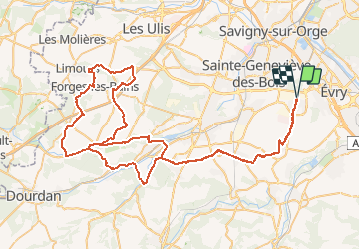
Tocht Fiets van 97 km beschikbaar op Île-de-France, Essonne, Bondoufle. Deze tocht wordt voorgesteld door Lucquiaud.
Beschrijving
départ et retour à Bondoufle , salle des fêtes.
ravitaillement du 60 km et du 90 km ( 2 passages) au château du Marais à Val Saint Germain
Plaatsbepaling
Land:
France
Regio :
Île-de-France
Departement/Provincie :
Essonne
Gemeente :
Bondoufle
Locatie:
Unknown
Vertrek:(Dec)
Vertrek:(UTM)
454185 ; 5385255 (31U) N.
Opmerkingen
Wandeltochten in de omgeving
![Tocht Te voet Morsang-sur-Orge - Boucle 20 km Morsang sur Orge - Photo](https://media.geolcdn.com/t/375/260/d37a7650-c254-47eb-95bf-21850c3f3dae.jpg&format=jpg&maxdim=2)
![Te voet Te voet](https://static1.geolcdn.com/sitytour/trail-icons/100.png)
Boucle 20 km Morsang sur Orge
Te voet
Gemakkelijk
Morsang-sur-Orge,
Île-de-France,
Essonne,
France
![](/images/other/stat-length.png)
20 km | 22 km-effort
5h 6min
![](https://static1.geolcdn.com/siteimages/upload/files/16400158638029165_repeat_loop_refresh_sync_direction_icon.png)
Ja
![Tocht Mountainbike Bondoufle - rando](https://media.geolcdn.com/t/375/260/ext.jpg?maxdim=2&url=https%3A%2F%2Fstatic1.geolcdn.com%2Fsiteimages%2Fupload%2Ffiles%2F1524743154velo.jpg)
![Mountainbike Mountainbike](https://static1.geolcdn.com/sitytour/trail-icons/202.png)
rando "sec" dimanche 07/02/2021
Mountainbike
Gemakkelijk
(1)
Bondoufle,
Île-de-France,
Essonne,
France
![](/images/other/stat-length.png)
56 km | 63 km-effort
8min
![](https://static1.geolcdn.com/siteimages/upload/files/16400158638029165_repeat_loop_refresh_sync_direction_icon.png)
Ja
![Tocht Mountainbike Bondoufle - Senart - Photo](https://media.geolcdn.com/t/375/260/ext.jpg?maxdim=2&url=https%3A%2F%2Fstatic1.geolcdn.com%2Fsiteimages%2Fupload%2Ffiles%2F1524743154velo.jpg)
![Mountainbike Mountainbike](https://static1.geolcdn.com/sitytour/trail-icons/202.png)
Senart
Mountainbike
Zeer moeilijk
(1)
Bondoufle,
Île-de-France,
Essonne,
France
![](/images/other/stat-length.png)
46 km | 52 km-effort
3h 30min
![](https://static1.geolcdn.com/siteimages/upload/files/16400158638029165_repeat_loop_refresh_sync_direction_icon.png)
Ja
![Tocht Mountainbike Bondoufle - Sortie club du 29/09/2019 - Photo](https://media.geolcdn.com/t/375/260/ext.jpg?maxdim=2&url=https%3A%2F%2Fstatic1.geolcdn.com%2Fsiteimages%2Fupload%2Ffiles%2F1524743154velo.jpg)
![Mountainbike Mountainbike](https://static1.geolcdn.com/sitytour/trail-icons/202.png)
Sortie club du 29/09/2019
Mountainbike
Moeilijk
(1)
Bondoufle,
Île-de-France,
Essonne,
France
![](/images/other/stat-length.png)
32 km | 36 km-effort
2h 25min
![](https://static1.geolcdn.com/siteimages/upload/files/16400158638029165_repeat_loop_refresh_sync_direction_icon.png)
Ja
![Tocht Stappen Fleury-Mérogis - Fleury-Mérogis - Forêt Régionale de Saint-Eutrope - Photo](https://media.geolcdn.com/t/375/260/6448ff66-5599-4ef7-ab6f-bd578a291243.jpg&format=jpg&maxdim=2)
![Stappen Stappen](https://static1.geolcdn.com/sitytour/trail-icons/101.png)
Fleury-Mérogis - Forêt Régionale de Saint-Eutrope
Stappen
Gemakkelijk
Fleury-Mérogis,
Île-de-France,
Essonne,
France
![](/images/other/stat-length.png)
6,3 km | 7 km-effort
1h 35min
![](https://static1.geolcdn.com/siteimages/upload/files/16400158638029165_repeat_loop_refresh_sync_direction_icon.png)
Ja
![Tocht Te voet Soisy-sur-Seine - Boucle Soisy / Seine / Sénart - Photo](https://media.geolcdn.com/t/375/260/4a1feccf-2abe-4449-b3b1-c318219c819e.jpg&format=jpg&maxdim=2)
![Te voet Te voet](https://static1.geolcdn.com/sitytour/trail-icons/100.png)
Boucle Soisy / Seine / Sénart
Te voet
Heel gemakkelijk
Soisy-sur-Seine,
Île-de-France,
Essonne,
France
![](/images/other/stat-length.png)
18,6 km | 21 km-effort
4h 49min
![](https://static1.geolcdn.com/siteimages/upload/files/16400158638029165_repeat_loop_refresh_sync_direction_icon.png)
Ja
![Tocht Mountainbike Bondoufle - Autodrome - Photo](https://media.geolcdn.com/t/375/260/ext.jpg?maxdim=2&url=https%3A%2F%2Fstatic1.geolcdn.com%2Fsiteimages%2Fupload%2Ffiles%2F1524743154velo.jpg)
![Mountainbike Mountainbike](https://static1.geolcdn.com/sitytour/trail-icons/202.png)
Autodrome
Mountainbike
Zeer moeilijk
(1)
Bondoufle,
Île-de-France,
Essonne,
France
![](/images/other/stat-length.png)
48 km | 54 km-effort
3h 44min
![](https://static1.geolcdn.com/siteimages/upload/files/16400158638029165_repeat_loop_refresh_sync_direction_icon.png)
Ja
![Tocht Mountainbike Bondoufle - Bondoufle -Baulne 58KM - Photo](https://media.geolcdn.com/t/375/260/ext.jpg?maxdim=2&url=https%3A%2F%2Fstatic1.geolcdn.com%2Fsiteimages%2Fupload%2Ffiles%2F1524743154velo.jpg)
![Mountainbike Mountainbike](https://static1.geolcdn.com/sitytour/trail-icons/202.png)
Bondoufle -Baulne 58KM
Mountainbike
Gemakkelijk
(1)
Bondoufle,
Île-de-France,
Essonne,
France
![](/images/other/stat-length.png)
58 km | 66 km-effort
4h 34min
![](https://static1.geolcdn.com/siteimages/upload/files/16400158638029165_repeat_loop_refresh_sync_direction_icon.png)
Neen
![Tocht Mountainbike Bondoufle - Bondoufle - Lardy 60 Km - Photo](https://media.geolcdn.com/t/375/260/ext.jpg?maxdim=2&url=https%3A%2F%2Fstatic1.geolcdn.com%2Fsiteimages%2Fupload%2Ffiles%2F1524743154velo.jpg)
![Mountainbike Mountainbike](https://static1.geolcdn.com/sitytour/trail-icons/202.png)
Bondoufle - Lardy 60 Km
Mountainbike
Moeilijk
(1)
Bondoufle,
Île-de-France,
Essonne,
France
![](/images/other/stat-length.png)
60 km | 68 km-effort
4h 43min
![](https://static1.geolcdn.com/siteimages/upload/files/16400158638029165_repeat_loop_refresh_sync_direction_icon.png)
Ja