Tocht Stappen Moncaup - MONCAUP-Circuit vert des fontaines - Photo

MONCAUP-Circuit vert des fontaines

 Polo-31
Polo-31

Gebruiker

© OpenStreetMap contributors
Lengte
Lengte
9,9 km
Max. hoogte
Max. hoogte
285 m
Positief hoogteverschil
236 m
Km-Effort
Km-Effort  
13 km
Min. hoogte
Min. hoogte
192 m
Negatief hoogteverschil
232 m
Boucle
Boucle
Ja
Datum van aanmaak :
2014-12-10 00:00:00.0
Laatste wijziging :
2014-12-10 00:00:00.0

(0 Bericht)

Stappen
Stappen
2h47
Moeilijkheid : Heel gemakkelijk

Scan deze QR-code om de tocht te openen in de SityTrail-applicatie

Gratisgps-wandelapplicatie

Logo SityTrail SityTrail

IGN / Geografische instituten

SityTrail uit de App Store downloaden SityTrail uit Google Play downloaden

Logo SityTrail SityTrail World

De wereld gaat voor u open

SityTrail uit de App Store downloaden SityTrail uit Google Play downloaden SityTrail op Huawei AppGallery downloaden

Over ons

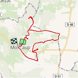
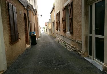
Tocht Stappen van 9,9 km beschikbaar op Nieuw-Aquitanië, Pyrénées-Atlantiques, Moncaup. Deze tocht wordt voorgesteld door Polo-31.

Beschrijving

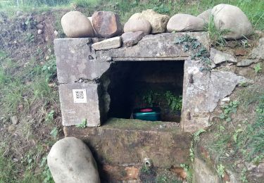
Départ de l'Eglise de Montcaup. Circuit balisé par de petites flèches vertes. 5 Fontaines sont accessibles depuis le parcours. L'accès est effectué pour 4 d'entres elles par un petit Aller/Retour. Les Fontaines : Puyo, Mayné, Geus, Houmère et Floris.

Hoogteprofiel

Foto's

Plaatsbepaling

Land:
France
Regio :
Nieuw-Aquitanië
Departement/Provincie :
Pyrénées-Atlantiques
Gemeente :
Moncaup
Locatie:
Unknown
Vertrek:(Dec)
Vertrek:(UTM)
737987 ; 4818602 (30T) N.

Wandeltochten in de omgeving

Tocht Stappen Lembeye - LEMBEYE Labelisation le chemin de la ligne
Stappen
GUIDE
marmotte65

Stappen

Medium
Lembeye, Nieuw-Aquitanië, Pyrénées-Atlantiques, France
7 km | 8,8 km-effort
1h 59min
Ja
Tocht Stappen Bassillon-Vauzé - BASSILLON VAUZE G4
Stappen
GUIDE
marmotte65

Stappen

Moeilijk
Bassillon-Vauzé, Nieuw-Aquitanië, Pyrénées-Atlantiques, France
10,6 km | 12,8 km-effort
3h 18min
Ja
Tocht Stappen Lembeye - LEMBEYE  Terra aventura  - Photo
Stappen
GUIDE
marmotte65

Stappen

Gemakkelijk
Lembeye, Nieuw-Aquitanië, Pyrénées-Atlantiques, France
3,1 km | 3,6 km-effort
47min
Ja
Tocht Stappen Lembeye - LEMBEYE La ligne M2 - Photo
Stappen
GUIDE
marmotte65

Stappen

Gemakkelijk
Lembeye, Nieuw-Aquitanië, Pyrénées-Atlantiques, France
6,8 km | 8,6 km-effort
1h 40min
Ja
Tocht Te voet Moncaup - 2020-08-15_19h39m22_Cirkwi-Le_sentier_des_fontaines (1) - Photo
Te voet
GUIDE
marmotte65

Te voet

Gemakkelijk
Moncaup, Nieuw-Aquitanië, Pyrénées-Atlantiques, France
13,4 km | 17,6 km-effort
Onbekend
Ja
Tocht Stappen Moncaup - MONCAUP  chemin des fontaines M1-fait - Photo
Stappen
GUIDE
marmotte65

Stappen

Gemakkelijk
Moncaup, Nieuw-Aquitanië, Pyrénées-Atlantiques, France
9,7 km | 12,3 km-effort
2h 41min
Ja
Tocht Te voet Lembeye - 06 - Lembeye - Photo
Te voet
GUIDE
marmotte65

Te voet

Gemakkelijk
Lembeye, Nieuw-Aquitanië, Pyrénées-Atlantiques, France
5,5 km | 6,9 km-effort
1h 33min
Neen
Tocht Te voet Lembeye - LEMBEYE chemin de la ligne M2 bis - Photo
Te voet
GUIDE
marmotte65

Te voet

Gemakkelijk
Lembeye, Nieuw-Aquitanië, Pyrénées-Atlantiques, France
7,1 km | 9,1 km-effort
Onbekend
Ja
Tocht Stappen Lembeye - LEMBEYE  chemin de la ligne M1  - Photo
Stappen
GUIDE
marmotte65

Stappen

Heel gemakkelijk
Lembeye, Nieuw-Aquitanië, Pyrénées-Atlantiques, France
10,2 km | 12,4 km-effort
2h 44min
Ja


Sluiten
Mijn abonnementen