![](/images/other/stat-length.png)
![Tocht Stappen Dehlingen -](https://media.geolcdn.com/t/1900/400/ext.pjpeg?maxdim=2&url=https%3A%2F%2Fstatic1.geolcdn.com%2Fsiteimages%2Fupload%2Ffiles%2F1553511878bg_sport_marche.png)
" Speckfest "
helmut68
Gebruiker
![Lengte](/images/other/stat-length.png)
Lengte
6,2 km
![Max. hoogte](https://static1.geolcdn.com/siteimages/upload/files/1508320355ic_sort_altitude_max_24dp.png)
Max. hoogte
350 m
![Positief hoogteverschil](https://static1.geolcdn.com/siteimages/upload/files/1508320355ic_sort_den_pos_24dp.png)
Positief hoogteverschil
109 m
![Km-Effort](/images/other/stat-length.png)
Km-Effort
7,7 km
![Min. hoogte](https://static1.geolcdn.com/siteimages/upload/files/1508320355ic_sort_altitude_min_24dp.png)
Min. hoogte
250 m
![Negatief hoogteverschil](https://static1.geolcdn.com/siteimages/upload/files/1508320355ic_sort_den_neg_24dp.png)
Negatief hoogteverschil
104 m
![Boucle](https://static1.geolcdn.com/siteimages/upload/files/16400158638029165_repeat_loop_refresh_sync_direction_icon.png)
Boucle
Neen
Datum van aanmaak :
2020-02-09 09:15:39.657
Laatste wijziging :
2020-02-09 18:15:08.867
![Stappen](https://static1.geolcdn.com/sitytour/trail-icons/101.png)
1h24
Moeilijkheid : Heel gemakkelijk
![Scan deze QR-code om de tocht te openen in de SityTrail-applicatie](https://capi.geolives.com/qq0zvz2zws4bq2lad0pu/sitytour/trails/2329751/qr.png?size=200)
Gratisgps-wandelapplicatie
Over ons
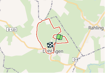
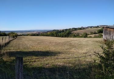
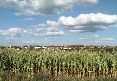
Tocht Stappen van 6,2 km beschikbaar op Grand Est, Bas-Rhin, Dehlingen. Deze tocht wordt voorgesteld door helmut68.
Beschrijving
Journée traditionnelle au mois de février dans la commune de Dehlingen, qui commence par une promenade sur le ban de Dehlingen . Cela se prolonge par un repas axé sur du lard et jambon grillés dans une salle typique près de l'étang
Très sympathique et conviviale...
Plaatsbepaling
Land:
France
Regio :
Grand Est
Departement/Provincie :
Bas-Rhin
Gemeente :
Dehlingen
Locatie:
Unknown
Vertrek:(Dec)
Vertrek:(UTM)
367844 ; 5427359 (32U) N.
Opmerkingen
Wandeltochten in de omgeving
![Tocht Te voet Diemeringen - Croix bleue - Photo](https://media.geolcdn.com/t/375/260/038b5fbd-ad7d-4d8f-a6b9-4f60e8eebeb8.jpeg&format=jpg&maxdim=2)
![Te voet Te voet](https://static1.geolcdn.com/sitytour/trail-icons/100.png)
Croix bleue
Te voet
Gemakkelijk
Diemeringen,
Grand Est,
Bas-Rhin,
France
![](/images/other/stat-length.png)
12,3 km | 16,1 km-effort
3h 39min
![](https://static1.geolcdn.com/siteimages/upload/files/16400158638029165_repeat_loop_refresh_sync_direction_icon.png)
Neen
![Tocht Te voet Diemeringen - Triangle bleu - Photo](https://media.geolcdn.com/t/375/260/d4b9e7be-1430-47f3-af7c-96cdacf9298e.jpeg&format=jpg&maxdim=2)
![Te voet Te voet](https://static1.geolcdn.com/sitytour/trail-icons/100.png)
Triangle bleu
Te voet
Gemakkelijk
Diemeringen,
Grand Est,
Bas-Rhin,
France
![](/images/other/stat-length.png)
7,6 km | 9,6 km-effort
2h 10min
![](https://static1.geolcdn.com/siteimages/upload/files/16400158638029165_repeat_loop_refresh_sync_direction_icon.png)
Neen
![Tocht Te voet Diemeringen - Comtesse Sophie de Nassau - Photo](https://media.geolcdn.com/t/375/260/8c2b8556-e0a8-4065-811c-0a8a71e07fa2.jpeg&format=jpg&maxdim=2)
![Te voet Te voet](https://static1.geolcdn.com/sitytour/trail-icons/100.png)
Comtesse Sophie de Nassau
Te voet
Gemakkelijk
Diemeringen,
Grand Est,
Bas-Rhin,
France
![](/images/other/stat-length.png)
6,9 km | 8,1 km-effort
1h 50min
![](https://static1.geolcdn.com/siteimages/upload/files/16400158638029165_repeat_loop_refresh_sync_direction_icon.png)
Ja
![Tocht Te voet Diemeringen - Yellow triangle - Photo](https://media.geolcdn.com/t/375/260/d4b9e7be-1430-47f3-af7c-96cdacf9298e.jpeg&format=jpg&maxdim=2)
![Te voet Te voet](https://static1.geolcdn.com/sitytour/trail-icons/100.png)
Yellow triangle
Te voet
Medium
Diemeringen,
Grand Est,
Bas-Rhin,
France
![](/images/other/stat-length.png)
21 km | 27 km-effort
6h 11min
![](https://static1.geolcdn.com/siteimages/upload/files/16400158638029165_repeat_loop_refresh_sync_direction_icon.png)
Neen
![Tocht sport Butten - 2024-04-07 Les vergers de Butten - Photo](https://media.geolcdn.com/t/375/260/21e8b322-75c7-495e-aaf5-acea1f138e8c.jpg&format=jpg&maxdim=2)
2024-04-07 Les vergers de Butten
sport
Heel gemakkelijk
Butten,
Grand Est,
Bas-Rhin,
France
![](/images/other/stat-length.png)
4,3 km | 5,5 km-effort
Onbekend
![](https://static1.geolcdn.com/siteimages/upload/files/16400158638029165_repeat_loop_refresh_sync_direction_icon.png)
Ja
![Tocht Stappen Dehlingen - Speckfest Dehlingen 2023 - Photo](https://media.geolcdn.com/t/375/260/50343618-1039-4cc2-8cba-88bb57992e6e.jpg&format=jpg&maxdim=2)
![Stappen Stappen](https://static1.geolcdn.com/sitytour/trail-icons/101.png)
Speckfest Dehlingen 2023
Stappen
Gemakkelijk
Dehlingen,
Grand Est,
Bas-Rhin,
France
![](/images/other/stat-length.png)
4,8 km | 6,2 km-effort
1h 10min
![](https://static1.geolcdn.com/siteimages/upload/files/16400158638029165_repeat_loop_refresh_sync_direction_icon.png)
Ja
![Tocht Te voet Ratzwiller - Chevalet vert - Photo](https://media.geolcdn.com/t/375/260/e1ca6c5c-ec16-4e6c-a9bf-b3aef84f04a4.jpeg&format=jpg&maxdim=2)
![Te voet Te voet](https://static1.geolcdn.com/sitytour/trail-icons/100.png)
Chevalet vert
Te voet
Gemakkelijk
Ratzwiller,
Grand Est,
Bas-Rhin,
France
![](/images/other/stat-length.png)
6,1 km | 8,2 km-effort
1h 51min
![](https://static1.geolcdn.com/siteimages/upload/files/16400158638029165_repeat_loop_refresh_sync_direction_icon.png)
Neen
![Tocht Stappen Dehlingen - Dehlingen Remelfing - Photo](https://media.geolcdn.com/t/375/260/4e1a1449-9bb3-41eb-9ea3-e127d0b3e233.jpg&format=jpg&maxdim=2)
![Stappen Stappen](https://static1.geolcdn.com/sitytour/trail-icons/101.png)
Dehlingen Remelfing
Stappen
Gemakkelijk
Dehlingen,
Grand Est,
Bas-Rhin,
France
![](/images/other/stat-length.png)
22 km | 27 km-effort
4h 32min
![](https://static1.geolcdn.com/siteimages/upload/files/16400158638029165_repeat_loop_refresh_sync_direction_icon.png)
Neen
![Tocht Stappen Dehlingen - Dehlingen Etting Schmittviller - Photo](https://media.geolcdn.com/t/375/260/a5ce3b6e-5dbc-40a8-8639-2b9848071e0f.jpg&format=jpg&maxdim=2)
![Stappen Stappen](https://static1.geolcdn.com/sitytour/trail-icons/101.png)
Dehlingen Etting Schmittviller
Stappen
Gemakkelijk
Dehlingen,
Grand Est,
Bas-Rhin,
France
![](/images/other/stat-length.png)
17,5 km | 21 km-effort
3h 54min
![](https://static1.geolcdn.com/siteimages/upload/files/16400158638029165_repeat_loop_refresh_sync_direction_icon.png)
Ja