Tocht Motorfiets Champfleury - Reims dormans  - Photo
 jcman51
jcman51

Gebruiker

© OpenStreetMap contributors
Lengte
Lengte
66 km
Max. hoogte
Max. hoogte
261 m
Positief hoogteverschil
993 m
Km-Effort
Km-Effort  
79 km
Min. hoogte
Min. hoogte
59 m
Negatief hoogteverschil
1021 m
Boucle
Boucle
Neen
Datum van aanmaak :
2020-02-08 10:05:52.0
Laatste wijziging :
2020-02-08 16:49:18.364

(0 Bericht)

Motorfiets
Motorfiets
6h39
Moeilijkheid : Zeer moeilijk

Scan deze QR-code om de tocht te openen in de SityTrail-applicatie

Gratisgps-wandelapplicatie

Logo SityTrail SityTrail

IGN / Geografische instituten

SityTrail uit de App Store downloaden SityTrail uit Google Play downloaden

Logo SityTrail SityTrail World

De wereld gaat voor u open

SityTrail uit de App Store downloaden SityTrail uit Google Play downloaden SityTrail op Huawei AppGallery downloaden

Over ons

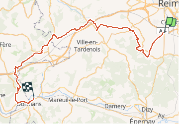
Tocht Motorfiets van 66 km beschikbaar op Grand Est, Marne, Champfleury. Deze tocht wordt voorgesteld door jcman51.

Beschrijving

Reims dormais

Hoogteprofiel

Plaatsbepaling

Land:
France
Regio :
Grand Est
Departement/Provincie :
Marne
Gemeente :
Champfleury
Locatie:
Unknown
Vertrek:(Dec)
Vertrek:(UTM)
573749 ; 5450556 (31U) N.

Wandeltochten in de omgeving

Tocht Stappen Reims - Sablière du mont de Berru - Reims - Photo
Stappen
tracegps

Stappen

Moeilijk
(2)
Reims, Grand Est, Marne, France
18,1 km | 21 km-effort
4h 15min
Ja
Tocht Lopen Reims - Sablière du mont de Berru - Reims - Photo
Lopen
tracegps

Lopen

Moeilijk
Reims, Grand Est, Marne, France
18,1 km | 21 km-effort
1h 45min
Ja
Tocht Mountainbike Villers-Allerand - La Montagne de Reims - Au SE de Villers-Allerand - Photo
Mountainbike
tracegps

Mountainbike

Moeilijk
Villers-Allerand, Grand Est, Marne, France
30 km | 38 km-effort
3h 0min
Ja
Tocht Stappen Écueil - Ecueil - Chamery 01 11 2012 - Photo
Stappen
mousetik

Stappen

Gemakkelijk
Écueil, Grand Est, Marne, France
5,4 km | 7,1 km-effort
Onbekend
Ja
Tocht Lopen Reims - Reims - Tour Télécom du mont de Berru - Photo
Lopen
tracegps

Lopen

Moeilijk
Reims, Grand Est, Marne, France
20 km | 24 km-effort
2h 0min
Ja
Tocht Lopen Reims - De Reims à Cernay - Photo
Lopen
tracegps

Lopen

Moeilijk
Reims, Grand Est, Marne, France
14 km | 16 km-effort
1h 15min
Ja
Tocht Stappen Reims - La Via Francigena - Reims - Châlons en Champagne - Photo
Stappen
tracegps

Stappen

Medium
Reims, Grand Est, Marne, France
61 km | 69 km-effort
12h 30min
Neen
Tocht Stappen Reims - copain coubertin - Photo
Stappen
Dominique Noyau

Stappen

Gemakkelijk
Reims, Grand Est, Marne, France
3,8 km | 4,3 km-effort
46min
Ja
Tocht Fietstoerisme Reims - Reims - Condé sur marne 36 km - Photo
Fietstoerisme
GUIDE
jeanmarcMasson

Fietstoerisme

Moeilijk
Reims, Grand Est, Marne, France
36 km | 38 km-effort
2h 37min
Neen


Sluiten
Mijn abonnementen