![](/images/other/stat-length.png)
![Tocht Stappen Otívar - OTIVAR Castillo Moscaril - Photo](https://media.geolcdn.com/t/1900/400/0f691502-7702-4e97-b4a7-20ff68f93bf9.jpg&format=pjpeg&maxdim=2)
OTIVAR Castillo Moscaril
jpipacific
Gebruiker
![Lengte](/images/other/stat-length.png)
![Max. hoogte](https://static1.geolcdn.com/siteimages/upload/files/1508320355ic_sort_altitude_max_24dp.png)
![Positief hoogteverschil](https://static1.geolcdn.com/siteimages/upload/files/1508320355ic_sort_den_pos_24dp.png)
![Km-Effort](/images/other/stat-length.png)
![Min. hoogte](https://static1.geolcdn.com/siteimages/upload/files/1508320355ic_sort_altitude_min_24dp.png)
![Negatief hoogteverschil](https://static1.geolcdn.com/siteimages/upload/files/1508320355ic_sort_den_neg_24dp.png)
![Boucle](https://static1.geolcdn.com/siteimages/upload/files/16400158638029165_repeat_loop_refresh_sync_direction_icon.png)
![Stappen](https://static1.geolcdn.com/sitytour/trail-icons/101.png)
1h58
Moeilijkheid : Medium
![Scan deze QR-code om de tocht te openen in de SityTrail-applicatie](https://capi.geolives.com/qq0zvz2zws4bq2lad0pu/sitytour/trails/2325972/qr.png?size=200)
Gratisgps-wandelapplicatie
Over ons
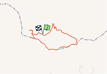
Tocht Stappen van 4,1 km beschikbaar op Andalusië, Granada, Otívar. Deze tocht wordt voorgesteld door jpipacific.
Beschrijving
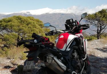
Accès au départ assez difficile sans 4X4 ou moto Trail ce qui est mon cas. A moins de partir de plus loin.
Rando assez difficile. Les dénivelés sont assez sévères.
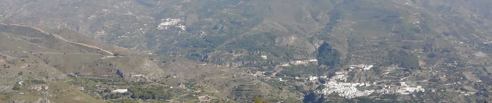
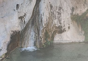
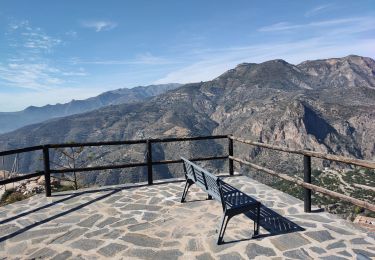
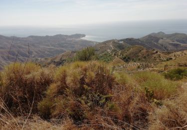
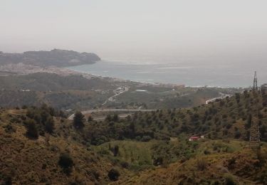
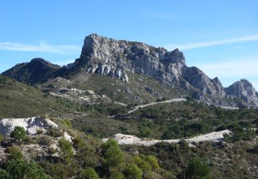
Les paysages sont très beaux avec vues sur la mer, sur les pointes de la Sierra Nevada et sur toutes les montagnes alentour.
Plaatsbepaling
Opmerkingen
Wandeltochten in de omgeving
![Tocht Stappen Lentegí - Poza de las animas - Photo](https://media.geolcdn.com/t/375/260/138d79bf-c8e6-4959-ad11-fb1767b7d5eb.jpg&format=jpg&maxdim=2)
![Stappen Stappen](https://static1.geolcdn.com/sitytour/trail-icons/101.png)
Stappen
![](/images/other/stat-length.png)
![](https://static1.geolcdn.com/siteimages/upload/files/16400158638029165_repeat_loop_refresh_sync_direction_icon.png)
![Tocht Stappen Lentegí - Lentegi Las Bizarras - Photo](https://media.geolcdn.com/t/375/260/6e3b7bc9-1a0d-4a1d-bbbf-2f25e6bc75de.jpg&format=jpg&maxdim=2)
![Stappen Stappen](https://static1.geolcdn.com/sitytour/trail-icons/101.png)
Stappen
![](/images/other/stat-length.png)
![](https://static1.geolcdn.com/siteimages/upload/files/16400158638029165_repeat_loop_refresh_sync_direction_icon.png)
![Tocht Moto-cross Lentegí - Lentegi Vélez de Benaudalla - Photo](https://media.geolcdn.com/t/375/260/82f69f2a-fa53-4f07-aef5-63c3aeaa5dc3.jpg&format=jpg&maxdim=2)
![Moto-cross Moto-cross](https://static1.geolcdn.com/sitytour/trail-icons/406.png)
Moto-cross
![](/images/other/stat-length.png)
![](https://static1.geolcdn.com/siteimages/upload/files/16400158638029165_repeat_loop_refresh_sync_direction_icon.png)
![Tocht Stappen Almuñécar - Rescate au dessus - Photo](https://media.geolcdn.com/t/375/260/ec5fb466-62dd-4930-bc43-4267f1602454.jpg&format=jpg&maxdim=2)
![Stappen Stappen](https://static1.geolcdn.com/sitytour/trail-icons/101.png)
Stappen
![](/images/other/stat-length.png)
![](https://static1.geolcdn.com/siteimages/upload/files/16400158638029165_repeat_loop_refresh_sync_direction_icon.png)
![Tocht Stappen Almuñécar - Au dessus de EL CERVAL - Photo](https://media.geolcdn.com/t/375/260/8cdb8405-48e9-44ea-a73a-31deabc2a61b.jpg&format=jpg&maxdim=2)
![Stappen Stappen](https://static1.geolcdn.com/sitytour/trail-icons/101.png)
Stappen
![](/images/other/stat-length.png)
![](https://static1.geolcdn.com/siteimages/upload/files/16400158638029165_repeat_loop_refresh_sync_direction_icon.png)
![Tocht Te voet Almuñécar - OTIVAR castillo Moscaril tour 2 - Photo](https://media.geolcdn.com/t/375/260/9f70cda7-72e7-4555-909c-15377c7c2dd6.jpg&format=jpg&maxdim=2)
![Te voet Te voet](https://static1.geolcdn.com/sitytour/trail-icons/100.png)
Te voet
![](/images/other/stat-length.png)
![](https://static1.geolcdn.com/siteimages/upload/files/16400158638029165_repeat_loop_refresh_sync_direction_icon.png)
![Tocht Stappen Almuñécar - Chemin de liaison El Cerval et Rescate - Photo](https://media.geolcdn.com/t/375/260/b00f9877-b089-4103-b8e5-b461cae5c9d5.jpg&format=jpg&maxdim=2)
![Stappen Stappen](https://static1.geolcdn.com/sitytour/trail-icons/101.png)
Stappen
![](/images/other/stat-length.png)
![](https://static1.geolcdn.com/siteimages/upload/files/16400158638029165_repeat_loop_refresh_sync_direction_icon.png)
![Stappen Stappen](https://static1.geolcdn.com/sitytour/trail-icons/101.png)
Stappen
![](/images/other/stat-length.png)
![](https://static1.geolcdn.com/siteimages/upload/files/16400158638029165_repeat_loop_refresh_sync_direction_icon.png)
![Tocht Stappen Almuñécar - Wikiloc - El Rescate - Photo](https://media.geolcdn.com/t/375/260/ext.jpg?maxdim=2&url=https%3A%2F%2Fstatic1.geolcdn.com%2Fsiteimages%2Fupload%2Ffiles%2F1553511878bg_sport_marche.png)
![Stappen Stappen](https://static1.geolcdn.com/sitytour/trail-icons/101.png)
Stappen
![](/images/other/stat-length.png)
![](https://static1.geolcdn.com/siteimages/upload/files/16400158638029165_repeat_loop_refresh_sync_direction_icon.png)