![](/images/other/stat-length.png)
![Tocht Stappen Magescq - MAGESCQ - Chêne de Nerthe - Photo](https://media.geolcdn.com/t/1900/400/4b4db19c-dab6-4949-bd9f-c2c258476ec7.jpg&format=pjpeg&maxdim=2)
MAGESCQ - Chêne de Nerthe
Licianus2
Gebruiker
![Lengte](/images/other/stat-length.png)
![Max. hoogte](https://static1.geolcdn.com/siteimages/upload/files/1508320355ic_sort_altitude_max_24dp.png)
![Positief hoogteverschil](https://static1.geolcdn.com/siteimages/upload/files/1508320355ic_sort_den_pos_24dp.png)
![Km-Effort](/images/other/stat-length.png)
![Min. hoogte](https://static1.geolcdn.com/siteimages/upload/files/1508320355ic_sort_altitude_min_24dp.png)
![Negatief hoogteverschil](https://static1.geolcdn.com/siteimages/upload/files/1508320355ic_sort_den_neg_24dp.png)
![Boucle](https://static1.geolcdn.com/siteimages/upload/files/16400158638029165_repeat_loop_refresh_sync_direction_icon.png)
![Stappen](https://static1.geolcdn.com/sitytour/trail-icons/101.png)
35m
Moeilijkheid : Heel gemakkelijk
![Scan deze QR-code om de tocht te openen in de SityTrail-applicatie](https://capi.geolives.com/qq0zvz2zws4bq2lad0pu/sitytour/trails/2324980/qr.png?size=200)
Gratisgps-wandelapplicatie
Over ons
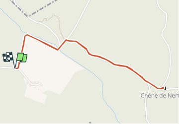
Tocht Stappen van 2,8 km beschikbaar op Nieuw-Aquitanië, Landes, Magescq. Deze tocht wordt voorgesteld door Licianus2.
Beschrijving
Petite balade dans les Landes à la découverte d'un arbre classé.
Cet arbre est situé sur la commune de Magescq.
Il faut compter demi-heure pour le trouver au milieu des pins.
Le départ peut se faire du point GPS à proximité d'une ferme.
Un panneau vous indique la direction. A l'entrée dans les bois, un fléchage bleu, vous indiquera la direction à suivre.
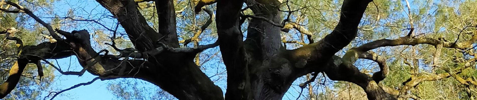
Dans le bois vous rencontrerez un croisement en Y prenez sur la droite et quelques centaines de mètres après, vous découvrirez le majestueux chêne pédonculé centenaire, sa taille est estimée entre 27 et 28 mètres de hauteur et son tronc 6.5 mètres de circonférence. L'âge estimé tourne aux alentours de 500 ans.
Même si l'univers Landais est avant tout constitué de pins Landais de nos jours. Il faut savoir qu'avant ce grand reboisement opéré au XIXe siècle afin d'assécher les terres Landaises pour en faire la plus grande forêt d'Europe d'un seul tenant. Elles étaient auparavant constituées de vaste marécages où seuls les moutons et les bergers s'aventuraient généralement. Il existait dans cette partie de la France à l'époque de nombreux chênes pédonculés et lièges dont peu sussistent.
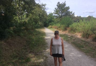
Le retour de cette promenade s’effectue par le même sentier qu'à l'aller.
Plaatsbepaling
Opmerkingen
Wandeltochten in de omgeving
![Tocht Stappen Saint-Paul-lès-Dax - 2022-08-22 RANDO EN PARTANT DU CAMPING DES ABESSES - Photo](https://media.geolcdn.com/t/375/260/c7490d3e-6280-4eb4-a9f3-19657f8fe68a.jpg&format=jpg&maxdim=2)
![Stappen Stappen](https://static1.geolcdn.com/sitytour/trail-icons/101.png)
Stappen
![](/images/other/stat-length.png)
![](https://static1.geolcdn.com/siteimages/upload/files/16400158638029165_repeat_loop_refresh_sync_direction_icon.png)
![Tocht Stappen Saint-Paul-lès-Dax - 2022-08-14 BALADE CAMPING DES ABESSES À U LAC DE CHRISTUS - Photo](https://media.geolcdn.com/t/375/260/413f9afc-ec67-4e03-9a2f-e548bcffec6e.jpg&format=jpg&maxdim=2)
![Stappen Stappen](https://static1.geolcdn.com/sitytour/trail-icons/101.png)
Stappen
![](/images/other/stat-length.png)
![](https://static1.geolcdn.com/siteimages/upload/files/16400158638029165_repeat_loop_refresh_sync_direction_icon.png)
![Tocht Stappen Saint-Paul-lès-Dax - randonnée près Saint Paul Lès Dax - Photo](https://media.geolcdn.com/t/375/260/ext.jpg?maxdim=2&url=https%3A%2F%2Fstatic1.geolcdn.com%2Fsiteimages%2Fupload%2Ffiles%2F1553511878bg_sport_marche.png)
![Stappen Stappen](https://static1.geolcdn.com/sitytour/trail-icons/101.png)
Stappen
![](/images/other/stat-length.png)
![](https://static1.geolcdn.com/siteimages/upload/files/16400158638029165_repeat_loop_refresh_sync_direction_icon.png)
![Tocht Stappen Saint-Paul-lès-Dax - Étang d ardy boucle 1 - Photo](https://media.geolcdn.com/t/375/260/ext.jpg?maxdim=2&url=https%3A%2F%2Fstatic1.geolcdn.com%2Fsiteimages%2Fupload%2Ffiles%2F1553511878bg_sport_marche.png)
![Stappen Stappen](https://static1.geolcdn.com/sitytour/trail-icons/101.png)
Stappen
![](/images/other/stat-length.png)
![](https://static1.geolcdn.com/siteimages/upload/files/16400158638029165_repeat_loop_refresh_sync_direction_icon.png)
![Tocht Stappen Saint-Paul-lès-Dax - Ballade autour du camping de St Paul les Dax - Photo](https://media.geolcdn.com/t/375/260/ext.jpg?maxdim=2&url=https%3A%2F%2Fstatic1.geolcdn.com%2Fsiteimages%2Fupload%2Ffiles%2F1553511878bg_sport_marche.png)
![Stappen Stappen](https://static1.geolcdn.com/sitytour/trail-icons/101.png)
Stappen
![](/images/other/stat-length.png)
![](https://static1.geolcdn.com/siteimages/upload/files/16400158638029165_repeat_loop_refresh_sync_direction_icon.png)
![Tocht Stappen Saint-Paul-lès-Dax - lac de christus - Photo](https://media.geolcdn.com/t/375/260/ext.jpg?maxdim=2&url=https%3A%2F%2Fstatic1.geolcdn.com%2Fsiteimages%2Fupload%2Ffiles%2F1553511878bg_sport_marche.png)
![Stappen Stappen](https://static1.geolcdn.com/sitytour/trail-icons/101.png)
Stappen
![](/images/other/stat-length.png)
![](https://static1.geolcdn.com/siteimages/upload/files/16400158638029165_repeat_loop_refresh_sync_direction_icon.png)
![Tocht Stappen Saint-Paul-lès-Dax - 26052022 - Photo](https://media.geolcdn.com/t/375/260/ext.jpg?maxdim=2&url=https%3A%2F%2Fstatic1.geolcdn.com%2Fsiteimages%2Fupload%2Ffiles%2F1553511878bg_sport_marche.png)
![Stappen Stappen](https://static1.geolcdn.com/sitytour/trail-icons/101.png)
Stappen
![](/images/other/stat-length.png)
![](https://static1.geolcdn.com/siteimages/upload/files/16400158638029165_repeat_loop_refresh_sync_direction_icon.png)
![Tocht Wegfiets Herm - Herm - Gamarde - Heugas - Photo](https://media.geolcdn.com/t/375/260/ext.jpg?maxdim=2&url=https%3A%2F%2Fstatic1.geolcdn.com%2Fsiteimages%2Fupload%2Ffiles%2F1524743154velo.jpg)
![Wegfiets Wegfiets](https://static1.geolcdn.com/sitytour/trail-icons/201.png)
Wegfiets
![](/images/other/stat-length.png)
![](https://static1.geolcdn.com/siteimages/upload/files/16400158638029165_repeat_loop_refresh_sync_direction_icon.png)
![Tocht Wegfiets Herm - Herm - Lesperon - Laluque - Photo](https://media.geolcdn.com/t/375/260/ext.jpg?maxdim=2&url=https%3A%2F%2Fstatic1.geolcdn.com%2Fsiteimages%2Fupload%2Ffiles%2F1524743154velo.jpg)
![Wegfiets Wegfiets](https://static1.geolcdn.com/sitytour/trail-icons/201.png)
Wegfiets
![](/images/other/stat-length.png)
![](https://static1.geolcdn.com/siteimages/upload/files/16400158638029165_repeat_loop_refresh_sync_direction_icon.png)