


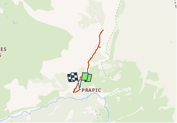


6,3 km | 9,9 km-effort

Gebruiker


Gratisgps-wandelapplicatie
 SityTrail
IGN / Geografische instituten
SityTrail World
De wereld gaat voor u open
Tocht Sneeuwschoenen van 4,9 km beschikbaar op Provence-Alpes-Côte d'Azur, Hautes-Alpes, Orcières. Deze tocht wordt voorgesteld door Marc Auger.
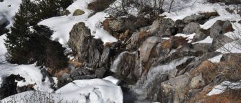
Randonnée raquette depuis le parking de Prapic aux cascades du torrent du Blaisil en passant par le tombeau du poète Joseph Reymond.
Suivant la température il est possible de voir les cascades en glace.


Stappen

Stappen

Stappen

Stappen

Ski randonnée

Stappen

Stappen

Ski randonnée

Ski randonnée