![](/images/other/stat-length.png)
![Tocht Te voet Cagnes-sur-Mer - GRP XYZ 1 - Photo](https://media.geolcdn.com/t/1900/400/ext.pjpeg?maxdim=2&url=https%3A%2F%2Fstatic1.geolcdn.com%2Fsiteimages%2Fupload%2Ffiles%2F1545311037marcheuse_200dpi.jpg)
GRP XYZ 1
REYPatrick
Gebruiker
![Lengte](/images/other/stat-length.png)
Lengte
55 km
![Max. hoogte](https://static1.geolcdn.com/siteimages/upload/files/1508320355ic_sort_altitude_max_24dp.png)
Max. hoogte
348 m
![Positief hoogteverschil](https://static1.geolcdn.com/siteimages/upload/files/1508320355ic_sort_den_pos_24dp.png)
Positief hoogteverschil
1433 m
![Km-Effort](/images/other/stat-length.png)
Km-Effort
74 km
![Min. hoogte](https://static1.geolcdn.com/siteimages/upload/files/1508320355ic_sort_altitude_min_24dp.png)
Min. hoogte
0 m
![Negatief hoogteverschil](https://static1.geolcdn.com/siteimages/upload/files/1508320355ic_sort_den_neg_24dp.png)
Negatief hoogteverschil
1433 m
![Boucle](https://static1.geolcdn.com/siteimages/upload/files/16400158638029165_repeat_loop_refresh_sync_direction_icon.png)
Boucle
Ja
Datum van aanmaak :
2020-02-03 09:44:56.06
Laatste wijziging :
2020-03-04 15:17:44.171
![Te voet](https://static1.geolcdn.com/sitytour/trail-icons/100.png)
92h00
Moeilijkheid : Medium
![Scan deze QR-code om de tocht te openen in de SityTrail-applicatie](https://capi.geolives.com/qq0zvz2zws4bq2lad0pu/sitytour/trails/2322683/qr.png?size=200)
Gratisgps-wandelapplicatie
Over ons
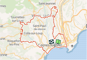
Tocht Te voet van 55 km beschikbaar op Provence-Alpes-Côte d'Azur, Alpes-Maritimes, Cagnes-sur-Mer. Deze tocht wordt voorgesteld door REYPatrick.
Beschrijving
Cagnes sur Mer, Villeneuve loubet, Roquefort, La colle sur Loup, Tourette sur Loup, Vence, Saint Laurent du Var, Saint Paul de Vence.
Plaatsbepaling
Land:
France
Regio :
Provence-Alpes-Côte d'Azur
Departement/Provincie :
Alpes-Maritimes
Gemeente :
Cagnes-sur-Mer
Locatie:
Unknown
Vertrek:(Dec)
Vertrek:(UTM)
352082 ; 4835418 (32T) N.
Opmerkingen
Wandeltochten in de omgeving
![Tocht Stappen Villeneuve-Loubet - plateau montmeuil - Photo](https://media.geolcdn.com/t/375/260/ext.jpg?maxdim=2&url=https%3A%2F%2Fstatic1.geolcdn.com%2Fsiteimages%2Fupload%2Ffiles%2F1553511878bg_sport_marche.png)
![Stappen Stappen](https://static1.geolcdn.com/sitytour/trail-icons/101.png)
plateau montmeuil
Stappen
Medium
(1)
Villeneuve-Loubet,
Provence-Alpes-Côte d'Azur,
Alpes-Maritimes,
France
![](/images/other/stat-length.png)
7,3 km | 8,9 km-effort
2h 27min
![](https://static1.geolcdn.com/siteimages/upload/files/16400158638029165_repeat_loop_refresh_sync_direction_icon.png)
Neen
![Tocht Stappen Villeneuve-Loubet - Parc departemental des Rives du Loup. - Photo](https://media.geolcdn.com/t/375/260/ext.jpg?maxdim=2&url=https%3A%2F%2Fservices.sitytrail.com%2FGeolivesWS%2FDownloadMedia.ashx%3FTrailID%3D464702%26Media%3Dfix__20150827152618.jpg)
![Stappen Stappen](https://static1.geolcdn.com/sitytour/trail-icons/101.png)
Parc departemental des Rives du Loup.
Stappen
Heel gemakkelijk
Villeneuve-Loubet,
Provence-Alpes-Côte d'Azur,
Alpes-Maritimes,
France
![](/images/other/stat-length.png)
6,9 km | 8 km-effort
1h 23min
![](https://static1.geolcdn.com/siteimages/upload/files/16400158638029165_repeat_loop_refresh_sync_direction_icon.png)
Ja
![Tocht Stappen Cagnes-sur-Mer - Villeneuve Loubet - Photo](https://media.geolcdn.com/t/375/260/3697ac0e-a76a-452a-a0b6-1b4fef9af2a0.jpg&format=jpg&maxdim=2)
![Stappen Stappen](https://static1.geolcdn.com/sitytour/trail-icons/101.png)
Villeneuve Loubet
Stappen
Gemakkelijk
Cagnes-sur-Mer,
Provence-Alpes-Côte d'Azur,
Alpes-Maritimes,
France
![](/images/other/stat-length.png)
13,3 km | 15,7 km-effort
6h 40min
![](https://static1.geolcdn.com/siteimages/upload/files/16400158638029165_repeat_loop_refresh_sync_direction_icon.png)
Ja
![Tocht Noords wandelen La Colle-sur-Loup - le long du Loup - Photo](https://media.geolcdn.com/t/375/260/323a9641-ff90-4c05-8bfa-f94db62a990b.jpg&format=jpg&maxdim=2)
![Noords wandelen Noords wandelen](https://static1.geolcdn.com/sitytour/trail-icons/102.png)
le long du Loup
Noords wandelen
Medium
La Colle-sur-Loup,
Provence-Alpes-Côte d'Azur,
Alpes-Maritimes,
France
![](/images/other/stat-length.png)
8,9 km | 10,3 km-effort
1h 54min
![](https://static1.geolcdn.com/siteimages/upload/files/16400158638029165_repeat_loop_refresh_sync_direction_icon.png)
Neen
![Tocht Stappen Villeneuve-Loubet - villeu - Photo](https://media.geolcdn.com/t/375/260/f934ad61-da42-41d4-aa37-c20917057afa.jpg&format=jpg&maxdim=2)
![Stappen Stappen](https://static1.geolcdn.com/sitytour/trail-icons/101.png)
villeu
Stappen
Moeilijk
Villeneuve-Loubet,
Provence-Alpes-Côte d'Azur,
Alpes-Maritimes,
France
![](/images/other/stat-length.png)
8,7 km | 12,4 km-effort
2h 11min
![](https://static1.geolcdn.com/siteimages/upload/files/16400158638029165_repeat_loop_refresh_sync_direction_icon.png)
Neen
![Tocht Stappen Villeneuve-Loubet - vill - Photo](https://media.geolcdn.com/t/375/260/c73938c8-47b2-46e8-b11d-c2bd9e4c64b0.jpg&format=jpg&maxdim=2)
![Stappen Stappen](https://static1.geolcdn.com/sitytour/trail-icons/101.png)
vill
Stappen
Gemakkelijk
Villeneuve-Loubet,
Provence-Alpes-Côte d'Azur,
Alpes-Maritimes,
France
![](/images/other/stat-length.png)
10,3 km | 14,2 km-effort
3h 40min
![](https://static1.geolcdn.com/siteimages/upload/files/16400158638029165_repeat_loop_refresh_sync_direction_icon.png)
Ja
![Tocht Stappen Villeneuve-Loubet - villeneuve loubet - Photo](https://media.geolcdn.com/t/375/260/8c9d478a-bff7-41c4-a3a9-5e72c54f5883.jpg&format=jpg&maxdim=2)
![Stappen Stappen](https://static1.geolcdn.com/sitytour/trail-icons/101.png)
villeneuve loubet
Stappen
Gemakkelijk
Villeneuve-Loubet,
Provence-Alpes-Côte d'Azur,
Alpes-Maritimes,
France
![](/images/other/stat-length.png)
10,3 km | 14,1 km-effort
5h 30min
![](https://static1.geolcdn.com/siteimages/upload/files/16400158638029165_repeat_loop_refresh_sync_direction_icon.png)
Ja
![Tocht Stappen Villeneuve-Loubet - Villeneuve Loubet -Marquisat - Photo](https://media.geolcdn.com/t/375/260/a83e40c8-4ef5-4a36-9725-830025757948.jpg&format=jpg&maxdim=2)
![Stappen Stappen](https://static1.geolcdn.com/sitytour/trail-icons/101.png)
Villeneuve Loubet -Marquisat
Stappen
Heel gemakkelijk
Villeneuve-Loubet,
Provence-Alpes-Côte d'Azur,
Alpes-Maritimes,
France
![](/images/other/stat-length.png)
11,5 km | 15,6 km-effort
3h 39min
![](https://static1.geolcdn.com/siteimages/upload/files/16400158638029165_repeat_loop_refresh_sync_direction_icon.png)
Neen
![Tocht Mountainbike Villeneuve-Loubet - vaigre nier marion - Photo](https://media.geolcdn.com/t/375/260/ext.jpg?maxdim=2&url=https%3A%2F%2Fservices.sitytrail.com%2FGeolivesWS%2FDownloadMedia.ashx%3FTrailID%3D133935%26Media%3D20120615154105.jpg)
![Mountainbike Mountainbike](https://static1.geolcdn.com/sitytour/trail-icons/202.png)
vaigre nier marion
Mountainbike
Heel gemakkelijk
Villeneuve-Loubet,
Provence-Alpes-Côte d'Azur,
Alpes-Maritimes,
France
![](/images/other/stat-length.png)
11,6 km | 13,2 km-effort
1h 29min
![](https://static1.geolcdn.com/siteimages/upload/files/16400158638029165_repeat_loop_refresh_sync_direction_icon.png)
Ja