


Sénégal IV 2ème Jour Tracé

Claude CHALMIN
Gebruiker
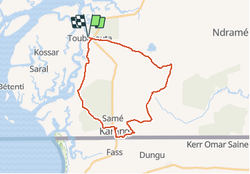

Lengte
80 km

Max. hoogte
50 m

Positief hoogteverschil
649 m
Km-Effort
88 km

Min. hoogte
2 m

Negatief hoogteverschil
649 m
Boucle
Ja
Datum van aanmaak :
2020-01-15 10:21:19.059
Laatste wijziging :
2020-01-15 18:23:59.425
6h40
Moeilijkheid : Gemakkelijk

Gratisgps-wandelapplicatie
 SityTrail
IGN / Geografische instituten
SityTrail World
De wereld gaat voor u open
Over ons
Tocht Quad van 80 km beschikbaar op Senegal. Deze tocht wordt voorgesteld door Claude CHALMIN.
Plaatsbepaling
Land:
Senegal
Regio :
Unknown
Departement/Provincie :
Unknown
Gemeente :
Unknown
Locatie:
Unknown
Vertrek:(Dec)
Vertrek:(UTM)
340369 ; 1524418 (28P) N.
Opmerkingen
Wandeltochten in de omgeving