![](/images/other/stat-length.png)
![Tocht Stappen Escoire - Escoire boucle de Lauterie 12 km - Photo](https://media.geolcdn.com/t/1900/400/ext.pjpeg?maxdim=2&url=https%3A%2F%2Fstatic1.geolcdn.com%2Fsiteimages%2Fupload%2Ffiles%2F1553511878bg_sport_marche.png)
Escoire boucle de Lauterie 12 km
YV24
Gebruiker
![Lengte](/images/other/stat-length.png)
Lengte
12,4 km
![Max. hoogte](https://static1.geolcdn.com/siteimages/upload/files/1508320355ic_sort_altitude_max_24dp.png)
Max. hoogte
221 m
![Positief hoogteverschil](https://static1.geolcdn.com/siteimages/upload/files/1508320355ic_sort_den_pos_24dp.png)
Positief hoogteverschil
293 m
![Km-Effort](/images/other/stat-length.png)
Km-Effort
16,3 km
![Min. hoogte](https://static1.geolcdn.com/siteimages/upload/files/1508320355ic_sort_altitude_min_24dp.png)
Min. hoogte
92 m
![Negatief hoogteverschil](https://static1.geolcdn.com/siteimages/upload/files/1508320355ic_sort_den_neg_24dp.png)
Negatief hoogteverschil
292 m
![Boucle](https://static1.geolcdn.com/siteimages/upload/files/16400158638029165_repeat_loop_refresh_sync_direction_icon.png)
Boucle
Ja
Datum van aanmaak :
2020-01-14 07:49:37.593
Laatste wijziging :
2020-01-14 17:27:59.086
![Stappen](https://static1.geolcdn.com/sitytour/trail-icons/101.png)
3h10
Moeilijkheid : Gemakkelijk
![Scan deze QR-code om de tocht te openen in de SityTrail-applicatie](https://capi.geolives.com/qq0zvz2zws4bq2lad0pu/sitytour/trails/2305525/qr.png?size=200)
Gratisgps-wandelapplicatie
Over ons
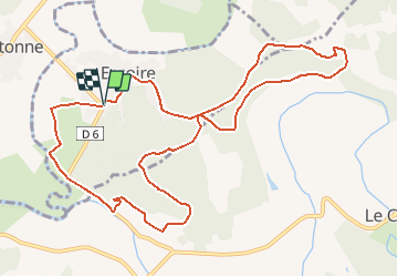
Tocht Stappen van 12,4 km beschikbaar op Nieuw-Aquitanië, Dordogne, Escoire. Deze tocht wordt voorgesteld door YV24.
Beschrijving
D'après tracé du GPAM d'août 2013.
2020 : Qqs places de parking au bout de la D6, devant le château.
Parcours varié, un peu vallonné, non balisé. . Rando sympa, praticable en tout temps.
Plaatsbepaling
Land:
France
Regio :
Nieuw-Aquitanië
Departement/Provincie :
Dordogne
Gemeente :
Escoire
Locatie:
Unknown
Vertrek:(Dec)
Vertrek:(UTM)
330843 ; 5008188 (31T) N.
Opmerkingen
Wandeltochten in de omgeving
![Tocht Stappen Antonne-et-Trigonant - Lanmary variente 1 - Photo](https://media.geolcdn.com/t/375/260/401f1b0e-efaf-4088-b5dc-ed2841cc4d88.jpg&format=jpg&maxdim=2)
![Stappen Stappen](https://static1.geolcdn.com/sitytour/trail-icons/101.png)
Lanmary variente 1
Stappen
Medium
(1)
Antonne-et-Trigonant,
Nieuw-Aquitanië,
Dordogne,
France
![](/images/other/stat-length.png)
8,4 km | 10,4 km-effort
2h 52min
![](https://static1.geolcdn.com/siteimages/upload/files/16400158638029165_repeat_loop_refresh_sync_direction_icon.png)
Ja
![Tocht Stappen Bassillac et Auberoche - Le Change Roc 9km - Photo](https://media.geolcdn.com/t/375/260/ext.jpg?maxdim=2&url=https%3A%2F%2Fstatic1.geolcdn.com%2Fsiteimages%2Fupload%2Ffiles%2F1553511878bg_sport_marche.png)
![Stappen Stappen](https://static1.geolcdn.com/sitytour/trail-icons/101.png)
Le Change Roc 9km
Stappen
Heel gemakkelijk
(1)
Bassillac et Auberoche,
Nieuw-Aquitanië,
Dordogne,
France
![](/images/other/stat-length.png)
9,3 km | 12,2 km-effort
2h 43min
![](https://static1.geolcdn.com/siteimages/upload/files/16400158638029165_repeat_loop_refresh_sync_direction_icon.png)
Ja
![Tocht Stappen Bassillac et Auberoche - Le Change Pommiers 9km - Photo](https://media.geolcdn.com/t/375/260/ext.jpg?maxdim=2&url=https%3A%2F%2Fstatic1.geolcdn.com%2Fsiteimages%2Fupload%2Ffiles%2F1553511878bg_sport_marche.png)
![Stappen Stappen](https://static1.geolcdn.com/sitytour/trail-icons/101.png)
Le Change Pommiers 9km
Stappen
Gemakkelijk
(1)
Bassillac et Auberoche,
Nieuw-Aquitanië,
Dordogne,
France
![](/images/other/stat-length.png)
9 km | 11,3 km-effort
2h 32min
![](https://static1.geolcdn.com/siteimages/upload/files/16400158638029165_repeat_loop_refresh_sync_direction_icon.png)
Ja
![Tocht Te voet Bassillac et Auberoche - Les chabannes - Photo](https://media.geolcdn.com/t/375/260/a8aade46-e147-4b35-b4a7-c1d555488ef4.jpg&format=jpg&maxdim=2)
![Te voet Te voet](https://static1.geolcdn.com/sitytour/trail-icons/100.png)
Les chabannes
Te voet
Gemakkelijk
Bassillac et Auberoche,
Nieuw-Aquitanië,
Dordogne,
France
![](/images/other/stat-length.png)
6,3 km | 8,2 km-effort
1h 52min
![](https://static1.geolcdn.com/siteimages/upload/files/16400158638029165_repeat_loop_refresh_sync_direction_icon.png)
Ja
![Tocht Noords wandelen Antonne-et-Trigonant - Lanmary Sibaudie à l'envers - Photo](https://media.geolcdn.com/t/375/260/ext.jpg?maxdim=2&url=https%3A%2F%2Fstatic1.geolcdn.com%2Fsiteimages%2Fupload%2Ffiles%2F1545311037marcheuse_200dpi.jpg)
![Noords wandelen Noords wandelen](https://static1.geolcdn.com/sitytour/trail-icons/102.png)
Lanmary Sibaudie à l'envers
Noords wandelen
Heel gemakkelijk
(2)
Antonne-et-Trigonant,
Nieuw-Aquitanië,
Dordogne,
France
![](/images/other/stat-length.png)
11,8 km | 15,1 km-effort
2h 51min
![](https://static1.geolcdn.com/siteimages/upload/files/16400158638029165_repeat_loop_refresh_sync_direction_icon.png)
Ja
![Tocht Noords wandelen Antonne-et-Trigonant - Lanmary 8,7 km - Photo](https://media.geolcdn.com/t/375/260/ext.jpg?maxdim=2&url=https%3A%2F%2Fstatic1.geolcdn.com%2Fsiteimages%2Fupload%2Ffiles%2F1545311037marcheuse_200dpi.jpg)
![Noords wandelen Noords wandelen](https://static1.geolcdn.com/sitytour/trail-icons/102.png)
Lanmary 8,7 km
Noords wandelen
Gemakkelijk
(1)
Antonne-et-Trigonant,
Nieuw-Aquitanië,
Dordogne,
France
![](/images/other/stat-length.png)
8,7 km | 10,5 km-effort
1h 58min
![](https://static1.geolcdn.com/siteimages/upload/files/16400158638029165_repeat_loop_refresh_sync_direction_icon.png)
Ja
![Tocht Noords wandelen Antonne-et-Trigonant - lanmary 9.7 - Photo](https://media.geolcdn.com/t/375/260/ext.jpg?maxdim=2&url=https%3A%2F%2Fstatic1.geolcdn.com%2Fsiteimages%2Fupload%2Ffiles%2F1545311037marcheuse_200dpi.jpg)
![Noords wandelen Noords wandelen](https://static1.geolcdn.com/sitytour/trail-icons/102.png)
lanmary 9.7
Noords wandelen
Heel gemakkelijk
(1)
Antonne-et-Trigonant,
Nieuw-Aquitanië,
Dordogne,
France
![](/images/other/stat-length.png)
9,8 km | 12,2 km-effort
2h 13min
![](https://static1.geolcdn.com/siteimages/upload/files/16400158638029165_repeat_loop_refresh_sync_direction_icon.png)
Ja
![Tocht Noords wandelen Antonne-et-Trigonant - lanmary 11 km - Photo](https://media.geolcdn.com/t/375/260/ext.jpg?maxdim=2&url=https%3A%2F%2Fstatic1.geolcdn.com%2Fsiteimages%2Fupload%2Ffiles%2F1545311037marcheuse_200dpi.jpg)
![Noords wandelen Noords wandelen](https://static1.geolcdn.com/sitytour/trail-icons/102.png)
lanmary 11 km
Noords wandelen
Heel gemakkelijk
(1)
Antonne-et-Trigonant,
Nieuw-Aquitanië,
Dordogne,
France
![](/images/other/stat-length.png)
11,1 km | 13,7 km-effort
2h 39min
![](https://static1.geolcdn.com/siteimages/upload/files/16400158638029165_repeat_loop_refresh_sync_direction_icon.png)
Ja
![Tocht Noords wandelen Antonne-et-Trigonant - Croix du Rat - Photo](https://media.geolcdn.com/t/375/260/ext.jpg?maxdim=2&url=https%3A%2F%2Fstatic1.geolcdn.com%2Fsiteimages%2Fupload%2Ffiles%2F1545311037marcheuse_200dpi.jpg)
![Noords wandelen Noords wandelen](https://static1.geolcdn.com/sitytour/trail-icons/102.png)
Croix du Rat
Noords wandelen
Heel gemakkelijk
(1)
Antonne-et-Trigonant,
Nieuw-Aquitanië,
Dordogne,
France
![](/images/other/stat-length.png)
10,8 km | 13,4 km-effort
2h 28min
![](https://static1.geolcdn.com/siteimages/upload/files/16400158638029165_repeat_loop_refresh_sync_direction_icon.png)
Ja
bien