![](/images/other/stat-length.png)
![Tocht Te voet Cloyes-les-Trois-Rivières - Montigny le Gannelon classique matin PC26sept2020 - Photo](https://media.geolcdn.com/t/1900/400/ext.pjpeg?maxdim=2&url=https%3A%2F%2Fstatic1.geolcdn.com%2Fsiteimages%2Fupload%2Ffiles%2F1545311037marcheuse_200dpi.jpg)
Montigny le Gannelon classique matin PC26sept2020
CRUZILLACP
Gebruiker
![Lengte](/images/other/stat-length.png)
Lengte
12,2 km
![Max. hoogte](https://static1.geolcdn.com/siteimages/upload/files/1508320355ic_sort_altitude_max_24dp.png)
Max. hoogte
147 m
![Positief hoogteverschil](https://static1.geolcdn.com/siteimages/upload/files/1508320355ic_sort_den_pos_24dp.png)
Positief hoogteverschil
119 m
![Km-Effort](/images/other/stat-length.png)
Km-Effort
13,8 km
![Min. hoogte](https://static1.geolcdn.com/siteimages/upload/files/1508320355ic_sort_altitude_min_24dp.png)
Min. hoogte
94 m
![Negatief hoogteverschil](https://static1.geolcdn.com/siteimages/upload/files/1508320355ic_sort_den_neg_24dp.png)
Negatief hoogteverschil
123 m
![Boucle](https://static1.geolcdn.com/siteimages/upload/files/16400158638029165_repeat_loop_refresh_sync_direction_icon.png)
Boucle
Neen
Datum van aanmaak :
2020-01-14 12:36:40.409
Laatste wijziging :
2020-02-03 09:35:27.851
![Te voet](https://static1.geolcdn.com/sitytour/trail-icons/100.png)
--
Moeilijkheid : Medium
![Scan deze QR-code om de tocht te openen in de SityTrail-applicatie](https://capi.geolives.com/qq0zvz2zws4bq2lad0pu/sitytour/trails/2305142/qr.png?size=200)
Gratisgps-wandelapplicatie
Over ons
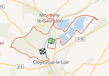
Tocht Te voet van 12,2 km beschikbaar op Centre-Val de Loire, Eure-et-Loir, Cloyes-les-Trois-Rivières. Deze tocht wordt voorgesteld door CRUZILLACP.
Beschrijving
Départ de Cloyes camping Le Val Fleuri.
Circuit Héron Montigny le Gannelon
Circuit Mathieu Cochereau
Bois du Jard
Pique-nique Parc Emile Zola
Plaatsbepaling
Land:
France
Regio :
Centre-Val de Loire
Departement/Provincie :
Eure-et-Loir
Gemeente :
Cloyes-les-Trois-Rivières
Locatie:
Cloyes-sur-le-Loir
Vertrek:(Dec)
Vertrek:(UTM)
368107 ; 5318105 (31U) N.
Opmerkingen
Wandeltochten in de omgeving
![Tocht Stappen Cloyes-les-Trois-Rivières - Voie de Tours : 4 ème étape Cloyes - Vrndome - Poirier - Photo](https://media.geolcdn.com/t/375/260/28d4a587-913c-4aff-8e11-65ec6298b2ab.jpg&format=jpg&maxdim=2)
![Stappen Stappen](https://static1.geolcdn.com/sitytour/trail-icons/101.png)
Voie de Tours : 4 ème étape Cloyes - Vrndome - Poirier
Stappen
Moeilijk
Cloyes-les-Trois-Rivières,
Centre-Val de Loire,
Eure-et-Loir,
France
![](/images/other/stat-length.png)
44 km | 49 km-effort
8h 20min
![](https://static1.geolcdn.com/siteimages/upload/files/16400158638029165_repeat_loop_refresh_sync_direction_icon.png)
Neen
![Tocht Stappen Cloyes-les-Trois-Rivières - circuit du chevreuil - Photo](https://media.geolcdn.com/t/375/260/ext.jpg?maxdim=2&url=https%3A%2F%2Fstatic1.geolcdn.com%2Fsiteimages%2Fupload%2Ffiles%2F1553511878bg_sport_marche.png)
![Stappen Stappen](https://static1.geolcdn.com/sitytour/trail-icons/101.png)
circuit du chevreuil
Stappen
Heel gemakkelijk
Cloyes-les-Trois-Rivières,
Centre-Val de Loire,
Eure-et-Loir,
France
![](/images/other/stat-length.png)
6 km | 6,7 km-effort
1h 48min
![](https://static1.geolcdn.com/siteimages/upload/files/16400158638029165_repeat_loop_refresh_sync_direction_icon.png)
Neen
![Tocht Stappen Cloyes-les-Trois-Rivières - Montigny le guenelon - Photo](https://media.geolcdn.com/t/375/260/ext.jpg?maxdim=2&url=https%3A%2F%2Fstatic1.geolcdn.com%2Fsiteimages%2Fupload%2Ffiles%2F1553511878bg_sport_marche.png)
![Stappen Stappen](https://static1.geolcdn.com/sitytour/trail-icons/101.png)
Montigny le guenelon
Stappen
Gemakkelijk
Cloyes-les-Trois-Rivières,
Centre-Val de Loire,
Eure-et-Loir,
France
![](/images/other/stat-length.png)
21 km | 24 km-effort
6h 40min
![](https://static1.geolcdn.com/siteimages/upload/files/16400158638029165_repeat_loop_refresh_sync_direction_icon.png)
Neen
![Tocht Stappen Cloyes-les-Trois-Rivières - cloyes sur Loir - Photo](https://media.geolcdn.com/t/375/260/1e35d3dc-a027-4977-abd7-a051dbba0c52.jpg&format=jpg&maxdim=2)
![Stappen Stappen](https://static1.geolcdn.com/sitytour/trail-icons/101.png)
cloyes sur Loir
Stappen
Gemakkelijk
Cloyes-les-Trois-Rivières,
Centre-Val de Loire,
Eure-et-Loir,
France
![](/images/other/stat-length.png)
6,3 km | 7 km-effort
2h 7min
![](https://static1.geolcdn.com/siteimages/upload/files/16400158638029165_repeat_loop_refresh_sync_direction_icon.png)
Ja
![Tocht Stappen Cloyes-les-Trois-Rivières - St-Hilaire-sur-Yerre - Photo](https://media.geolcdn.com/t/375/260/ext.jpg?maxdim=2&url=https%3A%2F%2Fstatic1.geolcdn.com%2Fsiteimages%2Fupload%2Ffiles%2F1553511878bg_sport_marche.png)
![Stappen Stappen](https://static1.geolcdn.com/sitytour/trail-icons/101.png)
St-Hilaire-sur-Yerre
Stappen
Medium
Cloyes-les-Trois-Rivières,
Centre-Val de Loire,
Eure-et-Loir,
France
![](/images/other/stat-length.png)
18,1 km | 21 km-effort
4h 30min
![](https://static1.geolcdn.com/siteimages/upload/files/16400158638029165_repeat_loop_refresh_sync_direction_icon.png)
Ja
![Tocht Te voet Cloyes-les-Trois-Rivières - Douy PC27sept2020 - Photo](https://media.geolcdn.com/t/375/260/ext.jpg?maxdim=2&url=https%3A%2F%2Fstatic1.geolcdn.com%2Fsiteimages%2Fupload%2Ffiles%2F1545311037marcheuse_200dpi.jpg)
![Te voet Te voet](https://static1.geolcdn.com/sitytour/trail-icons/100.png)
Douy PC27sept2020
Te voet
Medium
Cloyes-les-Trois-Rivières,
Centre-Val de Loire,
Eure-et-Loir,
France
![](/images/other/stat-length.png)
11,3 km | 13 km-effort
Onbekend
![](https://static1.geolcdn.com/siteimages/upload/files/16400158638029165_repeat_loop_refresh_sync_direction_icon.png)
Ja
![Tocht Te voet Cloyes-les-Trois-Rivières - Montigny le Gannelon courte matin PC26sept2020 - Photo](https://media.geolcdn.com/t/375/260/ext.jpg?maxdim=2&url=https%3A%2F%2Fstatic1.geolcdn.com%2Fsiteimages%2Fupload%2Ffiles%2F1545311037marcheuse_200dpi.jpg)
![Te voet Te voet](https://static1.geolcdn.com/sitytour/trail-icons/100.png)
Montigny le Gannelon courte matin PC26sept2020
Te voet
Gemakkelijk
Cloyes-les-Trois-Rivières,
Centre-Val de Loire,
Eure-et-Loir,
France
![](/images/other/stat-length.png)
7 km | 8,1 km-effort
Onbekend
![](https://static1.geolcdn.com/siteimages/upload/files/16400158638029165_repeat_loop_refresh_sync_direction_icon.png)
Neen
![Tocht Auto Villebout - 2019-11-10 belle de - Photo](https://media.geolcdn.com/t/375/260/ext.jpg?maxdim=2&url=https%3A%2F%2Fstatic1.geolcdn.com%2Fsiteimages%2Fupload%2Ffiles%2F15247431544x4.jpg)
![Auto Auto](https://static1.geolcdn.com/sitytour/trail-icons/401.png)
2019-11-10 belle de
Auto
Villebout,
Centre-Val de Loire,
Loir-et-Cher,
France
![](/images/other/stat-length.png)
8,6 km | 9,4 km-effort
3h 6min
![](https://static1.geolcdn.com/siteimages/upload/files/16400158638029165_repeat_loop_refresh_sync_direction_icon.png)
Neen
![Tocht Stappen Cloyes-les-Trois-Rivières - 010 Cloyes Vendome - Photo](https://media.geolcdn.com/t/375/260/ext.jpg?maxdim=2&url=https%3A%2F%2Fstatic1.geolcdn.com%2Fsiteimages%2Fupload%2Ffiles%2F1553511878bg_sport_marche.png)
![Stappen Stappen](https://static1.geolcdn.com/sitytour/trail-icons/101.png)
010 Cloyes Vendome
Stappen
Heel gemakkelijk
Cloyes-les-Trois-Rivières,
Centre-Val de Loire,
Eure-et-Loir,
France
![](/images/other/stat-length.png)
36 km | 40 km-effort
8h 43min
![](https://static1.geolcdn.com/siteimages/upload/files/16400158638029165_repeat_loop_refresh_sync_direction_icon.png)
Neen