![](/images/other/stat-length.png)
![Tocht Stappen Retournac - mont gerbizon - Photo](https://media.geolcdn.com/t/1900/400/ext.pjpeg?maxdim=2&url=https%3A%2F%2Fstatic1.geolcdn.com%2Fsiteimages%2Fupload%2Ffiles%2F1553511878bg_sport_marche.png)
mont gerbizon
mmeu1
Gebruiker
![Lengte](/images/other/stat-length.png)
Lengte
11,2 km
![Max. hoogte](https://static1.geolcdn.com/siteimages/upload/files/1508320355ic_sort_altitude_max_24dp.png)
Max. hoogte
1033 m
![Positief hoogteverschil](https://static1.geolcdn.com/siteimages/upload/files/1508320355ic_sort_den_pos_24dp.png)
Positief hoogteverschil
505 m
![Km-Effort](/images/other/stat-length.png)
Km-Effort
17,9 km
![Min. hoogte](https://static1.geolcdn.com/siteimages/upload/files/1508320355ic_sort_altitude_min_24dp.png)
Min. hoogte
594 m
![Negatief hoogteverschil](https://static1.geolcdn.com/siteimages/upload/files/1508320355ic_sort_den_neg_24dp.png)
Negatief hoogteverschil
504 m
![Boucle](https://static1.geolcdn.com/siteimages/upload/files/16400158638029165_repeat_loop_refresh_sync_direction_icon.png)
Boucle
Ja
Datum van aanmaak :
2014-12-10 00:00:00.0
Laatste wijziging :
2014-12-10 00:00:00.0
![Stappen](https://static1.geolcdn.com/sitytour/trail-icons/101.png)
3h48
Moeilijkheid : Moeilijk
![Scan deze QR-code om de tocht te openen in de SityTrail-applicatie](https://capi.geolives.com/qq0zvz2zws4bq2lad0pu/sitytour/trails/229975/qr.png?size=200)
Gratisgps-wandelapplicatie
Over ons
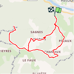
Tocht Stappen van 11,2 km beschikbaar op Auvergne-Rhône-Alpes, Haute-Loire, Retournac. Deze tocht wordt voorgesteld door mmeu1.
Beschrijving
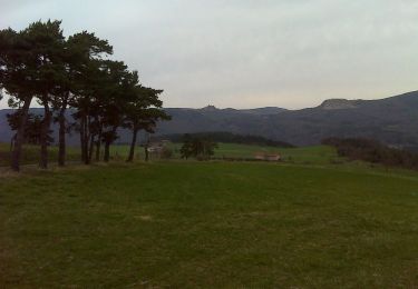
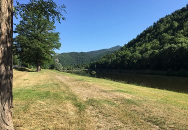
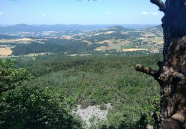
démarrer du centre de loisirs
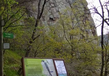
prendre un ancien balisage. Au début le chemin pentu est très dégradé et après Chanou le sentier est caillouteux et glissant.
Plaatsbepaling
Land:
France
Regio :
Auvergne-Rhône-Alpes
Departement/Provincie :
Haute-Loire
Gemeente :
Retournac
Locatie:
Unknown
Vertrek:(Dec)
Vertrek:(UTM)
580345 ; 5005351 (31T) N.
Opmerkingen
Wandeltochten in de omgeving
![Tocht Stappen Chamalières-sur-Loire - Suc de Bartou - Rocher de Costaros - Photo](https://media.geolcdn.com/t/375/260/cddc9f21-01a8-48b3-ab9a-c31899f6c6d0.jpg&format=jpg&maxdim=2)
![Stappen Stappen](https://static1.geolcdn.com/sitytour/trail-icons/101.png)
Suc de Bartou - Rocher de Costaros
Stappen
Medium
Chamalières-sur-Loire,
Auvergne-Rhône-Alpes,
Haute-Loire,
France
![](/images/other/stat-length.png)
4,5 km | 7 km-effort
1h 20min
![](https://static1.geolcdn.com/siteimages/upload/files/16400158638029165_repeat_loop_refresh_sync_direction_icon.png)
Ja
![Tocht Stappen Retournac - boucle de retournac - Photo](https://media.geolcdn.com/t/375/260/d668abd4-3210-4328-869c-7535b76a7c18.jpg&format=jpg&maxdim=2)
![Stappen Stappen](https://static1.geolcdn.com/sitytour/trail-icons/101.png)
boucle de retournac
Stappen
Medium
Retournac,
Auvergne-Rhône-Alpes,
Haute-Loire,
France
![](/images/other/stat-length.png)
5,5 km | 6,5 km-effort
1h 50min
![](https://static1.geolcdn.com/siteimages/upload/files/16400158638029165_repeat_loop_refresh_sync_direction_icon.png)
Ja
![Tocht Stappen Chamalières-sur-Loire - Le rocher de Costaros - Photo](https://media.geolcdn.com/t/375/260/52ddc995-081d-4181-afd7-7f549ccd3dfe.jpg&format=jpg&maxdim=2)
![Stappen Stappen](https://static1.geolcdn.com/sitytour/trail-icons/101.png)
Le rocher de Costaros
Stappen
Medium
Chamalières-sur-Loire,
Auvergne-Rhône-Alpes,
Haute-Loire,
France
![](/images/other/stat-length.png)
7,8 km | 11,4 km-effort
2h 21min
![](https://static1.geolcdn.com/siteimages/upload/files/16400158638029165_repeat_loop_refresh_sync_direction_icon.png)
Ja
![Tocht Mountainbike Chamalières-sur-Loire - Les 4 Sucs - Chamalières sur Loire - Photo](https://media.geolcdn.com/t/375/260/ext.jpg?maxdim=2&url=https%3A%2F%2Fservices.sitytrail.com%2FGeolivesWS%2FDownloadMedia.ashx%3FTrailID%3D317718%26Media%3D17029_6.jpg)
![Mountainbike Mountainbike](https://static1.geolcdn.com/sitytour/trail-icons/202.png)
Les 4 Sucs - Chamalières sur Loire
Mountainbike
Medium
Chamalières-sur-Loire,
Auvergne-Rhône-Alpes,
Haute-Loire,
France
![](/images/other/stat-length.png)
9,6 km | 13,2 km-effort
1h 0min
![](https://static1.geolcdn.com/siteimages/upload/files/16400158638029165_repeat_loop_refresh_sync_direction_icon.png)
Ja
![Tocht Stappen Chamalières-sur-Loire - Les 4 Sucs - Chamalières sur Loire - Photo](https://media.geolcdn.com/t/375/260/ext.jpg?maxdim=2&url=https%3A%2F%2Fservices.sitytrail.com%2FGeolivesWS%2FDownloadMedia.ashx%3FTrailID%3D317717%26Media%3D17029_6.jpg)
![Stappen Stappen](https://static1.geolcdn.com/sitytour/trail-icons/101.png)
Les 4 Sucs - Chamalières sur Loire
Stappen
Medium
Chamalières-sur-Loire,
Auvergne-Rhône-Alpes,
Haute-Loire,
France
![](/images/other/stat-length.png)
9,6 km | 13,2 km-effort
2h 30min
![](https://static1.geolcdn.com/siteimages/upload/files/16400158638029165_repeat_loop_refresh_sync_direction_icon.png)
Ja
![Tocht Stappen Rosières - Tour du mont Jalore via Roiron - Photo](https://media.geolcdn.com/t/375/260/1e5b93ef-3762-4007-a1a0-045e81222186.jpg&format=jpg&maxdim=2)
![Stappen Stappen](https://static1.geolcdn.com/sitytour/trail-icons/101.png)
Tour du mont Jalore via Roiron
Stappen
Medium
Rosières,
Auvergne-Rhône-Alpes,
Haute-Loire,
France
![](/images/other/stat-length.png)
6,8 km | 10 km-effort
1h 49min
![](https://static1.geolcdn.com/siteimages/upload/files/16400158638029165_repeat_loop_refresh_sync_direction_icon.png)
Ja
![Tocht Stappen Retournac - Bords de Loire à Retournac - Photo](https://media.geolcdn.com/t/375/260/b002891e-1078-428c-aa67-fd10e1607f61.jpg&format=jpg&maxdim=2)
![Stappen Stappen](https://static1.geolcdn.com/sitytour/trail-icons/101.png)
Bords de Loire à Retournac
Stappen
Gemakkelijk
Retournac,
Auvergne-Rhône-Alpes,
Haute-Loire,
France
![](/images/other/stat-length.png)
5,8 km | 6,9 km-effort
1h 15min
![](https://static1.geolcdn.com/siteimages/upload/files/16400158638029165_repeat_loop_refresh_sync_direction_icon.png)
Ja
![Tocht Stappen Rosières - les deux panoramas de Jalore - Photo](https://media.geolcdn.com/t/375/260/99fb9dd3-1205-4690-83c7-bbff5ba48be5.jpg&format=jpg&maxdim=2)
![Stappen Stappen](https://static1.geolcdn.com/sitytour/trail-icons/101.png)
les deux panoramas de Jalore
Stappen
Medium
Rosières,
Auvergne-Rhône-Alpes,
Haute-Loire,
France
![](/images/other/stat-length.png)
14,7 km | 22 km-effort
4h 35min
![](https://static1.geolcdn.com/siteimages/upload/files/16400158638029165_repeat_loop_refresh_sync_direction_icon.png)
Ja
![Tocht sport Chamalières-sur-Loire - Cavalière sur Loire - Photo](https://media.geolcdn.com/t/375/260/ext.jpg?maxdim=2&url=https%3A%2F%2Fsecurestorage.geolives.com%2Fsitytour%2Ftrail-bg%2Fdefault.jpg)
Cavalière sur Loire
sport
Heel gemakkelijk
Chamalières-sur-Loire,
Auvergne-Rhône-Alpes,
Haute-Loire,
France
![](/images/other/stat-length.png)
8,6 km | 12,4 km-effort
Onbekend
![](https://static1.geolcdn.com/siteimages/upload/files/16400158638029165_repeat_loop_refresh_sync_direction_icon.png)
Ja