![](/images/other/stat-length.png)
![Tocht Stappen Laives - Laives - lacs et ville - Photo](https://media.geolcdn.com/t/1900/400/ext.pjpeg?maxdim=2&url=https%3A%2F%2Fstatic1.geolcdn.com%2Fsiteimages%2Fupload%2Ffiles%2F1553511878bg_sport_marche.png)
Laives - lacs et ville
PapyChalon
Gebruiker
![Lengte](/images/other/stat-length.png)
Lengte
12,6 km
![Max. hoogte](https://static1.geolcdn.com/siteimages/upload/files/1508320355ic_sort_altitude_max_24dp.png)
Max. hoogte
232 m
![Positief hoogteverschil](https://static1.geolcdn.com/siteimages/upload/files/1508320355ic_sort_den_pos_24dp.png)
Positief hoogteverschil
108 m
![Km-Effort](/images/other/stat-length.png)
Km-Effort
14 km
![Min. hoogte](https://static1.geolcdn.com/siteimages/upload/files/1508320355ic_sort_altitude_min_24dp.png)
Min. hoogte
175 m
![Negatief hoogteverschil](https://static1.geolcdn.com/siteimages/upload/files/1508320355ic_sort_den_neg_24dp.png)
Negatief hoogteverschil
108 m
![Boucle](https://static1.geolcdn.com/siteimages/upload/files/16400158638029165_repeat_loop_refresh_sync_direction_icon.png)
Boucle
Ja
Datum van aanmaak :
2014-12-10 00:00:00.0
Laatste wijziging :
2014-12-10 00:00:00.0
![Stappen](https://static1.geolcdn.com/sitytour/trail-icons/101.png)
--
Moeilijkheid : Gemakkelijk
![Scan deze QR-code om de tocht te openen in de SityTrail-applicatie](https://capi.geolives.com/qq0zvz2zws4bq2lad0pu/sitytour/trails/229817/qr.png?size=200)
Gratisgps-wandelapplicatie
Over ons
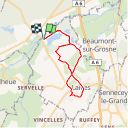
Tocht Stappen van 12,6 km beschikbaar op Bourgondië-Franche-Comté, Saône-et-Loire, Laives. Deze tocht wordt voorgesteld door PapyChalon.
Beschrijving
Rando Club MGEN Chalon
Une promenade à faire en famille. Une bonne partie se fait sur chemin goudronnée.
Attention : pendant l'été, l'accès près des lacs (base de loisirs) en voiture est payant.
Plaatsbepaling
Land:
France
Regio :
Bourgondië-Franche-Comté
Departement/Provincie :
Saône-et-Loire
Gemeente :
Laives
Locatie:
Unknown
Vertrek:(Dec)
Vertrek:(UTM)
639303 ; 5169855 (31T) N.
Opmerkingen
Wandeltochten in de omgeving
![Tocht Stappen Laives - Laives Montceau ragny page 106 - Photo](https://media.geolcdn.com/t/375/260/ext.jpg?maxdim=2&url=https%3A%2F%2Fstatic1.geolcdn.com%2Fsiteimages%2Fupload%2Ffiles%2F1553511878bg_sport_marche.png)
![Stappen Stappen](https://static1.geolcdn.com/sitytour/trail-icons/101.png)
Laives Montceau ragny page 106
Stappen
Moeilijk
(6)
Laives,
Bourgondië-Franche-Comté,
Saône-et-Loire,
France
![](/images/other/stat-length.png)
11,4 km | 15,3 km-effort
3h 28min
![](https://static1.geolcdn.com/siteimages/upload/files/16400158638029165_repeat_loop_refresh_sync_direction_icon.png)
Ja
![Tocht Stappen Laives - laives - Photo](https://media.geolcdn.com/t/375/260/e2bef5ab-edde-4773-8943-b12d798e0b99.jpg&format=jpg&maxdim=2)
![Stappen Stappen](https://static1.geolcdn.com/sitytour/trail-icons/101.png)
laives
Stappen
Moeilijk
Laives,
Bourgondië-Franche-Comté,
Saône-et-Loire,
France
![](/images/other/stat-length.png)
10,8 km | 12,3 km-effort
2h 15min
![](https://static1.geolcdn.com/siteimages/upload/files/16400158638029165_repeat_loop_refresh_sync_direction_icon.png)
Ja
![Tocht Stappen Sennecey-le-Grand - randonnée autour de Ruffey - Photo](https://media.geolcdn.com/t/375/260/944dd3e6-a0d7-44db-a205-6c0af14ac7c7.jpg&format=jpg&maxdim=2)
![Stappen Stappen](https://static1.geolcdn.com/sitytour/trail-icons/101.png)
randonnée autour de Ruffey
Stappen
Gemakkelijk
(1)
Sennecey-le-Grand,
Bourgondië-Franche-Comté,
Saône-et-Loire,
France
![](/images/other/stat-length.png)
12 km | 17,1 km-effort
3h 12min
![](https://static1.geolcdn.com/siteimages/upload/files/16400158638029165_repeat_loop_refresh_sync_direction_icon.png)
Ja
![Tocht Noords wandelen Laives - Laives - Photo](https://media.geolcdn.com/t/375/260/a5b3f030-7a28-4c8f-8808-e4107654a973.jpg&format=jpg&maxdim=2)
![Noords wandelen Noords wandelen](https://static1.geolcdn.com/sitytour/trail-icons/102.png)
Laives
Noords wandelen
Heel gemakkelijk
Laives,
Bourgondië-Franche-Comté,
Saône-et-Loire,
France
![](/images/other/stat-length.png)
11,4 km | 15,8 km-effort
2h 10min
![](https://static1.geolcdn.com/siteimages/upload/files/16400158638029165_repeat_loop_refresh_sync_direction_icon.png)
Ja
![Tocht Stappen Laives - Laives Vincelles St Michel Moyenne - Photo](https://media.geolcdn.com/t/375/260/ext.jpg?maxdim=2&url=https%3A%2F%2Fstatic1.geolcdn.com%2Fsiteimages%2Fupload%2Ffiles%2F1553511878bg_sport_marche.png)
![Stappen Stappen](https://static1.geolcdn.com/sitytour/trail-icons/101.png)
Laives Vincelles St Michel Moyenne
Stappen
Moeilijk
Laives,
Bourgondië-Franche-Comté,
Saône-et-Loire,
France
![](/images/other/stat-length.png)
10,5 km | 12,6 km-effort
2h 52min
![](https://static1.geolcdn.com/siteimages/upload/files/16400158638029165_repeat_loop_refresh_sync_direction_icon.png)
Ja
![Tocht Te voet Sennecey-le-Grand - G . Sennecey le Grand - Le Chemin Ferré - La male campagne - Les Teppes - et retour par maison Dieu . - Photo](https://media.geolcdn.com/t/375/260/ext.jpg?maxdim=2&url=https%3A%2F%2Fstatic1.geolcdn.com%2Fsiteimages%2Fupload%2Ffiles%2F1545311037marcheuse_200dpi.jpg)
![Te voet Te voet](https://static1.geolcdn.com/sitytour/trail-icons/100.png)
G . Sennecey le Grand - Le Chemin Ferré - La male campagne - Les Teppes - et ...
Te voet
Gemakkelijk
(1)
Sennecey-le-Grand,
Bourgondië-Franche-Comté,
Saône-et-Loire,
France
![](/images/other/stat-length.png)
10,2 km | 11,1 km-effort
2h 30min
![](https://static1.geolcdn.com/siteimages/upload/files/16400158638029165_repeat_loop_refresh_sync_direction_icon.png)
Ja
![Tocht Stappen Saint-Ambreuil - G . St Ambreuil - Carré aux loups - Les mouilles - Sommière de la GD Toile - Sommière de la Gd Manche - Retour par St Eloi . - Photo](https://media.geolcdn.com/t/375/260/ext.jpg?maxdim=2&url=https%3A%2F%2Fstatic1.geolcdn.com%2Fsiteimages%2Fupload%2Ffiles%2F1553511878bg_sport_marche.png)
![Stappen Stappen](https://static1.geolcdn.com/sitytour/trail-icons/101.png)
G . St Ambreuil - Carré aux loups - Les mouilles - Sommière de la GD Toile - ...
Stappen
Medium
Saint-Ambreuil,
Bourgondië-Franche-Comté,
Saône-et-Loire,
France
![](/images/other/stat-length.png)
10,8 km | 11,6 km-effort
2h 37min
![](https://static1.geolcdn.com/siteimages/upload/files/16400158638029165_repeat_loop_refresh_sync_direction_icon.png)
Ja
![Tocht Stappen Lalheue - G . Lalheue - Laives - Vincelles et retour par Le Vernoy . - Photo](https://media.geolcdn.com/t/375/260/ext.jpg?maxdim=2&url=https%3A%2F%2Fstatic1.geolcdn.com%2Fsiteimages%2Fupload%2Ffiles%2F1553511878bg_sport_marche.png)
![Stappen Stappen](https://static1.geolcdn.com/sitytour/trail-icons/101.png)
G . Lalheue - Laives - Vincelles et retour par Le Vernoy .
Stappen
Moeilijk
Lalheue,
Bourgondië-Franche-Comté,
Saône-et-Loire,
France
![](/images/other/stat-length.png)
11,7 km | 12,5 km-effort
2h 50min
![](https://static1.geolcdn.com/siteimages/upload/files/16400158638029165_repeat_loop_refresh_sync_direction_icon.png)
Ja
![Tocht Stappen Laives - G . Lacs de Laives - Beaumont - Laives et retour . - Photo](https://media.geolcdn.com/t/375/260/ext.jpg?maxdim=2&url=https%3A%2F%2Fstatic1.geolcdn.com%2Fsiteimages%2Fupload%2Ffiles%2F1553511878bg_sport_marche.png)
![Stappen Stappen](https://static1.geolcdn.com/sitytour/trail-icons/101.png)
G . Lacs de Laives - Beaumont - Laives et retour .
Stappen
Moeilijk
Laives,
Bourgondië-Franche-Comté,
Saône-et-Loire,
France
![](/images/other/stat-length.png)
11,2 km | 12,3 km-effort
2h 47min
![](https://static1.geolcdn.com/siteimages/upload/files/16400158638029165_repeat_loop_refresh_sync_direction_icon.png)
Ja