![](/images/other/stat-length.png)
![Tocht Te voet Arbéost - SityTrail - Arbeost le tour des quartiers d'Arbeost fait - Photo](https://media.geolcdn.com/t/1900/400/ext.pjpeg?maxdim=2&url=https%3A%2F%2Fstatic1.geolcdn.com%2Fsiteimages%2Fupload%2Ffiles%2F1545311037marcheuse_200dpi.jpg)
SityTrail - Arbeost le tour des quartiers d'Arbeost fait
marmotte65
Gebruiker GUIDE
![Lengte](/images/other/stat-length.png)
Lengte
6,7 km
![Max. hoogte](https://static1.geolcdn.com/siteimages/upload/files/1508320355ic_sort_altitude_max_24dp.png)
Max. hoogte
1122 m
![Positief hoogteverschil](https://static1.geolcdn.com/siteimages/upload/files/1508320355ic_sort_den_pos_24dp.png)
Positief hoogteverschil
425 m
![Km-Effort](/images/other/stat-length.png)
Km-Effort
12,3 km
![Min. hoogte](https://static1.geolcdn.com/siteimages/upload/files/1508320355ic_sort_altitude_min_24dp.png)
Min. hoogte
767 m
![Negatief hoogteverschil](https://static1.geolcdn.com/siteimages/upload/files/1508320355ic_sort_den_neg_24dp.png)
Negatief hoogteverschil
425 m
![Boucle](https://static1.geolcdn.com/siteimages/upload/files/16400158638029165_repeat_loop_refresh_sync_direction_icon.png)
Boucle
Ja
Datum van aanmaak :
2019-12-30 17:28:09.269
Laatste wijziging :
2019-12-31 08:24:06.733
![Te voet](https://static1.geolcdn.com/sitytour/trail-icons/100.png)
--
Moeilijkheid : Gemakkelijk
![Scan deze QR-code om de tocht te openen in de SityTrail-applicatie](https://capi.geolives.com/qq0zvz2zws4bq2lad0pu/sitytour/trails/2293601/qr.png?size=200)
Gratisgps-wandelapplicatie
Over ons
Tocht Te voet van 6,7 km beschikbaar op Occitanië, Hautes-Pyrénées, Arbéost. Deze tocht wordt voorgesteld door marmotte65.
Beschrijving
Départ de l’église d’Arbeost. Face au cimetière partir à G.
suivre le balisage jaune du PR.
sympathique balade un peu trop de goudron à mon gout, mais compensée par de beaux points de vue.
Plaatsbepaling
Land:
France
Regio :
Occitanië
Departement/Provincie :
Hautes-Pyrénées
Gemeente :
Arbéost
Locatie:
Unknown
Vertrek:(Dec)
Vertrek:(UTM)
721205 ; 4764087 (30T) N.
Opmerkingen
Wandeltochten in de omgeving
![Tocht Stappen Eaux-Bonnes - Le Pic Sanctus 2482m depuis Gourette - Photo](https://media.geolcdn.com/t/375/260/ext.jpg?maxdim=2&url=https%3A%2F%2Fservices.sitytrail.com%2FGeolivesWS%2FDownloadMedia.ashx%3FTrailID%3D103539%26Media%3D5754_1.jpg)
![Stappen Stappen](https://static1.geolcdn.com/sitytour/trail-icons/101.png)
Le Pic Sanctus 2482m depuis Gourette
Stappen
Moeilijk
(1)
Eaux-Bonnes,
Nieuw-Aquitanië,
Pyrénées-Atlantiques,
France
![](/images/other/stat-length.png)
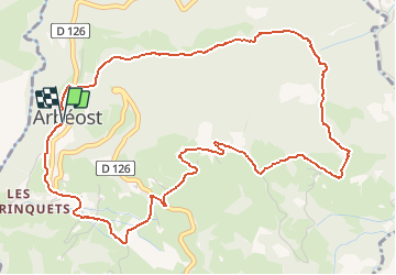
11,4 km | 26 km-effort
6h 0min
![](https://static1.geolcdn.com/siteimages/upload/files/16400158638029165_repeat_loop_refresh_sync_direction_icon.png)
Ja
![Tocht Lopen Eaux-Bonnes - GOURETTE la cabane de Bouy](https://media.geolcdn.com/t/375/260/ef1c0c9e-1794-4cec-b3c6-ee6194b0829e.jpg&format=jpg&maxdim=2)
![Lopen Lopen](https://static1.geolcdn.com/sitytour/trail-icons/103.png)
GOURETTE la cabane de Bouy "4135504"
Lopen
Heel gemakkelijk
Eaux-Bonnes,
Nieuw-Aquitanië,
Pyrénées-Atlantiques,
France
![](/images/other/stat-length.png)
9,9 km | 14,8 km-effort
3h 7min
![](https://static1.geolcdn.com/siteimages/upload/files/16400158638029165_repeat_loop_refresh_sync_direction_icon.png)
Ja
![Tocht sport Eaux-Bonnes - 2023-07-17_22h07m36_Balisage - Gourette Cabane de cezy - Photo](https://media.geolcdn.com/t/375/260/ext.jpg?maxdim=2&url=https%3A%2F%2Fsecurestorage.geolives.com%2Fsitytour%2Ftrail-bg%2Fdefault.jpg)
2023-07-17_22h07m36_Balisage - Gourette Cabane de cezy
sport
Heel gemakkelijk
(1)
Eaux-Bonnes,
Nieuw-Aquitanië,
Pyrénées-Atlantiques,
France
![](/images/other/stat-length.png)
13,9 km | 29 km-effort
Onbekend
![](https://static1.geolcdn.com/siteimages/upload/files/16400158638029165_repeat_loop_refresh_sync_direction_icon.png)
Neen
![Tocht Te voet Béost - Les crêtes d’Andreyt - Photo](https://media.geolcdn.com/t/375/260/6e4e7f92-4044-4711-ad6d-19596eb81d86.jpeg&format=jpg&maxdim=2)
![Te voet Te voet](https://static1.geolcdn.com/sitytour/trail-icons/100.png)
Les crêtes d’Andreyt
Te voet
Gemakkelijk
Béost,
Nieuw-Aquitanië,
Pyrénées-Atlantiques,
France
![](/images/other/stat-length.png)
9,6 km | 14,7 km-effort
3h 20min
![](https://static1.geolcdn.com/siteimages/upload/files/16400158638029165_repeat_loop_refresh_sync_direction_icon.png)
Ja
![Tocht Te voet Eaux-Bonnes - Le Lac d'Anglas - Photo](https://media.geolcdn.com/t/375/260/62e92f74-58d3-475a-994a-f5302851e450.jpeg&format=jpg&maxdim=2)
![Te voet Te voet](https://static1.geolcdn.com/sitytour/trail-icons/100.png)
Le Lac d'Anglas
Te voet
Gemakkelijk
Eaux-Bonnes,
Nieuw-Aquitanië,
Pyrénées-Atlantiques,
France
![](/images/other/stat-length.png)
3,6 km | 10,6 km-effort
2h 24min
![](https://static1.geolcdn.com/siteimages/upload/files/16400158638029165_repeat_loop_refresh_sync_direction_icon.png)
Neen
![Tocht Stappen Béost - soum de Grum fait - Photo](https://media.geolcdn.com/t/375/260/ext.jpg?maxdim=2&url=https%3A%2F%2Fstatic1.geolcdn.com%2Fsiteimages%2Fupload%2Ffiles%2F1553511878bg_sport_marche.png)
![Stappen Stappen](https://static1.geolcdn.com/sitytour/trail-icons/101.png)
soum de Grum fait
Stappen
Heel gemakkelijk
(1)
Béost,
Nieuw-Aquitanië,
Pyrénées-Atlantiques,
France
![](/images/other/stat-length.png)
8,1 km | 12,4 km-effort
4h 59min
![](https://static1.geolcdn.com/siteimages/upload/files/16400158638029165_repeat_loop_refresh_sync_direction_icon.png)
Ja
![Tocht Stappen Eaux-Bonnes - balisage GR10U 2023 - Photo](https://media.geolcdn.com/t/375/260/213ad87a-8380-4fb1-b585-b20ca185a4f6.jpg&format=jpg&maxdim=2)
![Stappen Stappen](https://static1.geolcdn.com/sitytour/trail-icons/101.png)
balisage GR10U 2023
Stappen
Zeer moeilijk
Eaux-Bonnes,
Nieuw-Aquitanië,
Pyrénées-Atlantiques,
France
![](/images/other/stat-length.png)
18,6 km | 36 km-effort
12h 13min
![](https://static1.geolcdn.com/siteimages/upload/files/16400158638029165_repeat_loop_refresh_sync_direction_icon.png)
Neen
![Tocht Stappen Arrens-Marsous - col de soulor, lac de soum, col de bazes, col de soulor - Photo](https://media.geolcdn.com/t/375/260/9c3094c8-45a9-4b5a-9dd6-274e8c565d12.jpg&format=jpg&maxdim=2)
![Stappen Stappen](https://static1.geolcdn.com/sitytour/trail-icons/101.png)
col de soulor, lac de soum, col de bazes, col de soulor
Stappen
Medium
Arrens-Marsous,
Occitanië,
Hautes-Pyrénées,
France
![](/images/other/stat-length.png)
16,4 km | 23 km-effort
5h 20min
![](https://static1.geolcdn.com/siteimages/upload/files/16400158638029165_repeat_loop_refresh_sync_direction_icon.png)
Ja
![Tocht Stappen Eaux-Bonnes - GOURETTE Terra aventura - Photo](https://media.geolcdn.com/t/375/260/eb543f6f-7e31-42f3-817a-ef9dcab45b42.jpg&format=jpg&maxdim=2)
![Stappen Stappen](https://static1.geolcdn.com/sitytour/trail-icons/101.png)
GOURETTE Terra aventura
Stappen
Medium
Eaux-Bonnes,
Nieuw-Aquitanië,
Pyrénées-Atlantiques,
France
![](/images/other/stat-length.png)
5 km | 9,1 km-effort
2h 4min
![](https://static1.geolcdn.com/siteimages/upload/files/16400158638029165_repeat_loop_refresh_sync_direction_icon.png)
Ja