![](/images/other/stat-length.png)
![Tocht Elektrische fiets Maaseik - Van Opoeteren naar Maaseik en terug - Photo](https://media.geolcdn.com/t/1900/400/ext.pjpeg?maxdim=2&url=https%3A%2F%2Fmedia.geolcdn.com%2Ff%2F4f18df67-d89e-4b8c-9c5f-a0cbe94db4f5.jpg)
Van Opoeteren naar Maaseik en terug
bometdehamer
Gebruiker
![Lengte](/images/other/stat-length.png)
Lengte
50 km
![Max. hoogte](https://static1.geolcdn.com/siteimages/upload/files/1508320355ic_sort_altitude_max_24dp.png)
Max. hoogte
87 m
![Positief hoogteverschil](https://static1.geolcdn.com/siteimages/upload/files/1508320355ic_sort_den_pos_24dp.png)
Positief hoogteverschil
353 m
![Km-Effort](/images/other/stat-length.png)
Km-Effort
55 km
![Min. hoogte](https://static1.geolcdn.com/siteimages/upload/files/1508320355ic_sort_altitude_min_24dp.png)
Min. hoogte
21 m
![Negatief hoogteverschil](https://static1.geolcdn.com/siteimages/upload/files/1508320355ic_sort_den_neg_24dp.png)
Negatief hoogteverschil
353 m
![Boucle](https://static1.geolcdn.com/siteimages/upload/files/16400158638029165_repeat_loop_refresh_sync_direction_icon.png)
Boucle
Ja
Datum van aanmaak :
2019-12-17 09:08:16.0
Laatste wijziging :
2019-12-17 14:22:26.508
![Elektrische fiets](https://static1.geolcdn.com/sitytour/trail-icons/205.png)
3h10
Moeilijkheid : Gemakkelijk
![Scan deze QR-code om de tocht te openen in de SityTrail-applicatie](https://capi.geolives.com/qq0zvz2zws4bq2lad0pu/sitytour/trails/2286546/qr.png?size=200)
Gratisgps-wandelapplicatie
Over ons
Tocht Elektrische fiets van 50 km beschikbaar op Vlaanderen, Limburg, Maaseik. Deze tocht wordt voorgesteld door bometdehamer.
Beschrijving
Mooie tocht langs fietsknooppunten 37, 43, 45, 26, 24, 25, 27, 28, 13, 12, 11, 36, 570, 35, 37. Voor elk wat wils: bossen, duinen, waterplassen, open veld, de Maasvallei, nog meer bossen. En heel veel paarden....
Plaatsbepaling
Land:
Belgium
Regio :
Vlaanderen
Departement/Provincie :
Limburg
Gemeente :
Maaseik
Locatie:
Opoeteren
Vertrek:(Dec)
Vertrek:(UTM)
684244 ; 5659555 (31U) N.
Opmerkingen
Wandeltochten in de omgeving
![Tocht Stappen Maaseik - 2021-11-06_16h45m30_930 - Photo](https://media.geolcdn.com/t/375/260/ext.jpg?maxdim=2&url=https%3A%2F%2Fmedia.geolcdn.com%2Ff%2F784b545d-0697-41ea-9878-b528d019e3de.jpg)
![Stappen Stappen](https://static1.geolcdn.com/sitytour/trail-icons/101.png)
2021-11-06_16h45m30_930
Stappen
Gemakkelijk
(1)
Maaseik,
Vlaanderen,
Limburg,
Belgium
![](/images/other/stat-length.png)
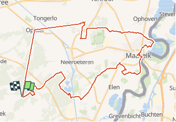
17,8 km | 20 km-effort
4h 38min
![](https://static1.geolcdn.com/siteimages/upload/files/16400158638029165_repeat_loop_refresh_sync_direction_icon.png)
Ja
![Tocht Te voet As - Heiderbos blauwe ruit - Photo](https://media.geolcdn.com/t/375/260/ext.jpg?maxdim=2&url=https%3A%2F%2Fmedia.geolcdn.com%2Ff%2Fe65c145e-dca4-4d58-ae17-fc8ca78c84c8.jpeg)
![Te voet Te voet](https://static1.geolcdn.com/sitytour/trail-icons/100.png)
Heiderbos blauwe ruit
Te voet
Gemakkelijk
As,
Vlaanderen,
Limburg,
Belgium
![](/images/other/stat-length.png)
7,7 km | 8,5 km-effort
1h 56min
![](https://static1.geolcdn.com/siteimages/upload/files/16400158638029165_repeat_loop_refresh_sync_direction_icon.png)
Ja
![Tocht Te voet Oudsbergen - Bosbeekvallei Rode vierkant - Photo](https://media.geolcdn.com/t/375/260/ext.jpg?maxdim=2&url=https%3A%2F%2Fmedia.geolcdn.com%2Ff%2F05b94e83-943e-4a8a-b6a2-23050984110f.jpeg)
![Te voet Te voet](https://static1.geolcdn.com/sitytour/trail-icons/100.png)
Bosbeekvallei Rode vierkant
Te voet
Gemakkelijk
Oudsbergen,
Vlaanderen,
Limburg,
Belgium
![](/images/other/stat-length.png)
6,3 km | 6,8 km-effort
1h 32min
![](https://static1.geolcdn.com/siteimages/upload/files/16400158638029165_repeat_loop_refresh_sync_direction_icon.png)
Ja
![Tocht Te voet Maaseik - Oudsberg Blauwe ruit - Photo](https://media.geolcdn.com/t/375/260/ext.jpg?maxdim=2&url=https%3A%2F%2Fmedia.geolcdn.com%2Ff%2Fbd436d3d-7786-4c28-877a-e4f4a8ff02e7.jpeg)
![Te voet Te voet](https://static1.geolcdn.com/sitytour/trail-icons/100.png)
Oudsberg Blauwe ruit
Te voet
Gemakkelijk
Maaseik,
Vlaanderen,
Limburg,
Belgium
![](/images/other/stat-length.png)
7 km | 8 km-effort
1h 48min
![](https://static1.geolcdn.com/siteimages/upload/files/16400158638029165_repeat_loop_refresh_sync_direction_icon.png)
Ja
![Tocht Te voet Oudsbergen - Oudsberg Blauwe ruit - Photo](https://media.geolcdn.com/t/375/260/ext.jpg?maxdim=2&url=https%3A%2F%2Fmedia.geolcdn.com%2Ff%2F587c0d46-8fc2-4453-a2ba-63c77f582c07.jpeg)
![Te voet Te voet](https://static1.geolcdn.com/sitytour/trail-icons/100.png)
Oudsberg Blauwe ruit
Te voet
Gemakkelijk
Oudsbergen,
Vlaanderen,
Limburg,
Belgium
![](/images/other/stat-length.png)
4 km | 4,5 km-effort
1h 0min
![](https://static1.geolcdn.com/siteimages/upload/files/16400158638029165_repeat_loop_refresh_sync_direction_icon.png)
Ja
![Tocht Te voet Maaseik - Oudsberg Groene rechthoek - Photo](https://media.geolcdn.com/t/375/260/ext.jpg?maxdim=2&url=https%3A%2F%2Fmedia.geolcdn.com%2Ff%2F87a0d596-d580-45a8-874d-5f76f3c7dee5.jpeg)
![Te voet Te voet](https://static1.geolcdn.com/sitytour/trail-icons/100.png)
Oudsberg Groene rechthoek
Te voet
Gemakkelijk
Maaseik,
Vlaanderen,
Limburg,
Belgium
![](/images/other/stat-length.png)
3,1 km | 3,4 km-effort
45min
![](https://static1.geolcdn.com/siteimages/upload/files/16400158638029165_repeat_loop_refresh_sync_direction_icon.png)
Ja
![Tocht Te voet Maaseik - Oudsberg Oranje bol - Photo](https://media.geolcdn.com/t/375/260/ext.jpg?maxdim=2&url=https%3A%2F%2Fmedia.geolcdn.com%2Ff%2Fbd436d3d-7786-4c28-877a-e4f4a8ff02e7.jpeg)
![Te voet Te voet](https://static1.geolcdn.com/sitytour/trail-icons/100.png)
Oudsberg Oranje bol
Te voet
Gemakkelijk
Maaseik,
Vlaanderen,
Limburg,
Belgium
![](/images/other/stat-length.png)
11,7 km | 13,4 km-effort
3h 2min
![](https://static1.geolcdn.com/siteimages/upload/files/16400158638029165_repeat_loop_refresh_sync_direction_icon.png)
Ja
![Tocht Te voet Dilsen-Stokkem - Bergerven Gele zeshoek - Photo](https://media.geolcdn.com/t/375/260/ext.jpg?maxdim=2&url=https%3A%2F%2Fmedia.geolcdn.com%2Ff%2F050a923b-2af9-40e2-aacc-99779fc4e3d7.jpeg)
![Te voet Te voet](https://static1.geolcdn.com/sitytour/trail-icons/100.png)
Bergerven Gele zeshoek
Te voet
Gemakkelijk
Dilsen-Stokkem,
Vlaanderen,
Limburg,
Belgium
![](/images/other/stat-length.png)
15,1 km | 17,5 km-effort
3h 58min
![](https://static1.geolcdn.com/siteimages/upload/files/16400158638029165_repeat_loop_refresh_sync_direction_icon.png)
Ja
![Tocht Te voet Maaseik - Bergerven Blauwe ruit - Photo](https://media.geolcdn.com/t/375/260/ext.jpg?maxdim=2&url=https%3A%2F%2Fmedia.geolcdn.com%2Ff%2F050a923b-2af9-40e2-aacc-99779fc4e3d7.jpeg)
![Te voet Te voet](https://static1.geolcdn.com/sitytour/trail-icons/100.png)
Bergerven Blauwe ruit
Te voet
Gemakkelijk
Maaseik,
Vlaanderen,
Limburg,
Belgium
![](/images/other/stat-length.png)
7,4 km | 8,3 km-effort
1h 53min
![](https://static1.geolcdn.com/siteimages/upload/files/16400158638029165_repeat_loop_refresh_sync_direction_icon.png)
Ja