![](/images/other/stat-length.png)
![Tocht Sneeuwschoenen Saint-Bonnet-en-Champsaur - 2019-12-12_19h16m42_rspg-les-payas-soubeyrane-1 - Photo](https://media.geolcdn.com/t/1900/400/ext.pjpeg?maxdim=2&url=https%3A%2F%2Fstatic1.geolcdn.com%2Fsiteimages%2Fupload%2Ffiles%2F1524743153raquette.jpg)
2019-12-12_19h16m42_rspg-les-payas-soubeyrane-1
joesic
Gebruiker
![Lengte](/images/other/stat-length.png)
Lengte
10,8 km
![Max. hoogte](https://static1.geolcdn.com/siteimages/upload/files/1508320355ic_sort_altitude_max_24dp.png)
Max. hoogte
1716 m
![Positief hoogteverschil](https://static1.geolcdn.com/siteimages/upload/files/1508320355ic_sort_den_pos_24dp.png)
Positief hoogteverschil
420 m
![Km-Effort](/images/other/stat-length.png)
Km-Effort
16,6 km
![Min. hoogte](https://static1.geolcdn.com/siteimages/upload/files/1508320355ic_sort_altitude_min_24dp.png)
Min. hoogte
1298 m
![Negatief hoogteverschil](https://static1.geolcdn.com/siteimages/upload/files/1508320355ic_sort_den_neg_24dp.png)
Negatief hoogteverschil
470 m
![Boucle](https://static1.geolcdn.com/siteimages/upload/files/16400158638029165_repeat_loop_refresh_sync_direction_icon.png)
Boucle
Neen
Datum van aanmaak :
2019-12-12 18:16:46.552
Laatste wijziging :
2019-12-28 09:00:20.369
![Sneeuwschoenen](https://static1.geolcdn.com/sitytour/trail-icons/504.png)
6m
Moeilijkheid : Medium
![Scan deze QR-code om de tocht te openen in de SityTrail-applicatie](https://capi.geolives.com/qq0zvz2zws4bq2lad0pu/sitytour/trails/2283752/qr.png?size=200)
Gratisgps-wandelapplicatie
Over ons
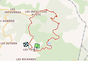
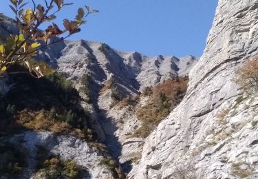
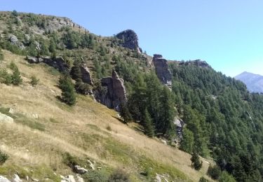
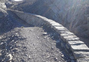
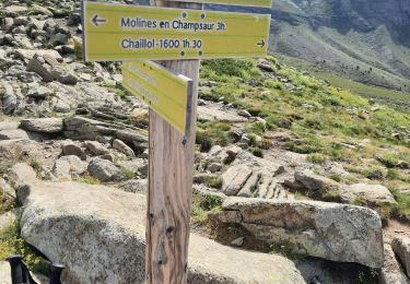
Tocht Sneeuwschoenen van 10,8 km beschikbaar op Provence-Alpes-Côte d'Azur, Hautes-Alpes, Saint-Bonnet-en-Champsaur. Deze tocht wordt voorgesteld door joesic.
Beschrijving
Départ aux Payas, sinon départ aux Infournas haut pour faire que la maison forestière de Soubeyranne.
Plaatsbepaling
Land:
France
Regio :
Provence-Alpes-Côte d'Azur
Departement/Provincie :
Hautes-Alpes
Gemeente :
Saint-Bonnet-en-Champsaur
Locatie:
Bénévent-et-Charbillac
Vertrek:(Dec)
Vertrek:(UTM)
270911 ; 4953040 (32T) N.
Opmerkingen
Wandeltochten in de omgeving
![Tocht Stappen Saint-Bonnet-en-Champsaur - Les infournas - Lac des Barbeyroux 22/09/23 - Photo](https://media.geolcdn.com/t/375/260/0538c280-feb5-4d65-96e8-19b0b69c47f0.jpg&format=jpg&maxdim=2)
![Stappen Stappen](https://static1.geolcdn.com/sitytour/trail-icons/101.png)
Les infournas - Lac des Barbeyroux 22/09/23
Stappen
Moeilijk
Saint-Bonnet-en-Champsaur,
Provence-Alpes-Côte d'Azur,
Hautes-Alpes,
France
![](/images/other/stat-length.png)
10,1 km | 16 km-effort
3h 38min
![](https://static1.geolcdn.com/siteimages/upload/files/16400158638029165_repeat_loop_refresh_sync_direction_icon.png)
Ja
![Tocht Stappen Saint-Michel-de-Chaillol - Col de l'Escalier - Photo](https://media.geolcdn.com/t/375/260/ab16f81e-2013-445c-8eb3-48638c0edd61.jpg&format=jpg&maxdim=2)
![Stappen Stappen](https://static1.geolcdn.com/sitytour/trail-icons/101.png)
Col de l'Escalier
Stappen
Moeilijk
Saint-Michel-de-Chaillol,
Provence-Alpes-Côte d'Azur,
Hautes-Alpes,
France
![](/images/other/stat-length.png)
16 km | 27 km-effort
6h 13min
![](https://static1.geolcdn.com/siteimages/upload/files/16400158638029165_repeat_loop_refresh_sync_direction_icon.png)
Ja
![Tocht Stappen Saint-Michel-de-Chaillol - Pic Queyrel - Photo](https://media.geolcdn.com/t/375/260/3587472a-93b3-4434-9291-823cc836fe6a.jpg&format=jpg&maxdim=2)
![Stappen Stappen](https://static1.geolcdn.com/sitytour/trail-icons/101.png)
Pic Queyrel
Stappen
Moeilijk
Saint-Michel-de-Chaillol,
Provence-Alpes-Côte d'Azur,
Hautes-Alpes,
France
![](/images/other/stat-length.png)
10,4 km | 19,8 km-effort
4h 29min
![](https://static1.geolcdn.com/siteimages/upload/files/16400158638029165_repeat_loop_refresh_sync_direction_icon.png)
Ja
![Tocht Stappen Saint-Michel-de-Chaillol - Pic du Tourond - Photo](https://media.geolcdn.com/t/375/260/01ce6341-dc1d-4078-9a13-caf8c777653c.jpg&format=jpg&maxdim=2)
![Stappen Stappen](https://static1.geolcdn.com/sitytour/trail-icons/101.png)
Pic du Tourond
Stappen
Zeer moeilijk
Saint-Michel-de-Chaillol,
Provence-Alpes-Côte d'Azur,
Hautes-Alpes,
France
![](/images/other/stat-length.png)
13,7 km | 27 km-effort
6h 14min
![](https://static1.geolcdn.com/siteimages/upload/files/16400158638029165_repeat_loop_refresh_sync_direction_icon.png)
Ja
![Tocht Stappen Saint-Michel-de-Chaillol - Lac de Malcros - Photo](https://media.geolcdn.com/t/375/260/6a7a1b5d-0b23-46a5-9179-bf8c821d0afb.jpg&format=jpg&maxdim=2)
![Stappen Stappen](https://static1.geolcdn.com/sitytour/trail-icons/101.png)
Lac de Malcros
Stappen
Zeer moeilijk
Saint-Michel-de-Chaillol,
Provence-Alpes-Côte d'Azur,
Hautes-Alpes,
France
![](/images/other/stat-length.png)
18,7 km | 34 km-effort
7h 43min
![](https://static1.geolcdn.com/siteimages/upload/files/16400158638029165_repeat_loop_refresh_sync_direction_icon.png)
Ja
![Tocht Stappen La Fare-en-Champsaur - Le Girolet - Photo](https://media.geolcdn.com/t/375/260/db985afe-8ded-41a5-8002-487c3b42ed04.jpg&format=jpg&maxdim=2)
![Stappen Stappen](https://static1.geolcdn.com/sitytour/trail-icons/101.png)
Le Girolet
Stappen
Medium
La Fare-en-Champsaur,
Provence-Alpes-Côte d'Azur,
Hautes-Alpes,
France
![](/images/other/stat-length.png)
11,6 km | 24 km-effort
4h 45min
![](https://static1.geolcdn.com/siteimages/upload/files/16400158638029165_repeat_loop_refresh_sync_direction_icon.png)
Ja
![Tocht Stappen Saint-Michel-de-Chaillol - pic de queyrel - Photo](https://media.geolcdn.com/t/375/260/16bf5dfe-1e8f-41f7-8280-542f457efdf9.jpg&format=jpg&maxdim=2)
![Stappen Stappen](https://static1.geolcdn.com/sitytour/trail-icons/101.png)
pic de queyrel
Stappen
Zeer moeilijk
Saint-Michel-de-Chaillol,
Provence-Alpes-Côte d'Azur,
Hautes-Alpes,
France
![](/images/other/stat-length.png)
10,8 km | 21 km-effort
5h 40min
![](https://static1.geolcdn.com/siteimages/upload/files/16400158638029165_repeat_loop_refresh_sync_direction_icon.png)
Ja
![Tocht Stappen Saint-Michel-de-Chaillol - Tête ouest de Mal Cros 11/08/18 - Photo](https://media.geolcdn.com/t/375/260/8702d498-6db2-40a6-b115-ed3ce3d7c0b6.jpg&format=jpg&maxdim=2)
![Stappen Stappen](https://static1.geolcdn.com/sitytour/trail-icons/101.png)
Tête ouest de Mal Cros 11/08/18
Stappen
Zeer moeilijk
Saint-Michel-de-Chaillol,
Provence-Alpes-Côte d'Azur,
Hautes-Alpes,
France
![](/images/other/stat-length.png)
21 km | 40 km-effort
8h 2min
![](https://static1.geolcdn.com/siteimages/upload/files/16400158638029165_repeat_loop_refresh_sync_direction_icon.png)
Ja
![Tocht Stappen Saint-Michel-de-Chaillol - col de la pisse - Photo](https://media.geolcdn.com/t/375/260/8e690fd3-f0ad-4120-9a92-3c8fe4646f31.jpg&format=jpg&maxdim=2)
![Stappen Stappen](https://static1.geolcdn.com/sitytour/trail-icons/101.png)
col de la pisse
Stappen
Medium
Saint-Michel-de-Chaillol,
Provence-Alpes-Côte d'Azur,
Hautes-Alpes,
France
![](/images/other/stat-length.png)
13,2 km | 23 km-effort
5h 54min
![](https://static1.geolcdn.com/siteimages/upload/files/16400158638029165_repeat_loop_refresh_sync_direction_icon.png)
Ja