Tocht Stappen Valencisse - Chambon sur cisse - Photo
 Jacky Caillé
Jacky Caillé

Gebruiker

© OpenStreetMap contributors
Lengte
Lengte
15,3 km
Max. hoogte
Max. hoogte
152 m
Positief hoogteverschil
237 m
Km-Effort
Km-Effort  
18,4 km
Min. hoogte
Min. hoogte
73 m
Negatief hoogteverschil
237 m
Boucle
Boucle
Ja
Datum van aanmaak :
2019-11-20 07:32:24.361
Laatste wijziging :
2019-11-20 11:36:29.328

(0 Bericht)

Stappen
Stappen
3h25
Moeilijkheid : Medium

Scan deze QR-code om de tocht te openen in de SityTrail-applicatie

Gratisgps-wandelapplicatie

Logo SityTrail SityTrail

IGN / Geografische instituten

SityTrail uit de App Store downloaden SityTrail uit Google Play downloaden

Logo SityTrail SityTrail World

De wereld gaat voor u open

SityTrail uit de App Store downloaden SityTrail uit Google Play downloaden SityTrail op Huawei AppGallery downloaden

Over ons

Tocht Stappen van 15,3 km beschikbaar op Centre-Val de Loire, Loir-et-Cher, Valencisse. Deze tocht wordt voorgesteld door Jacky Caillé.

Beschrijving

Rando avec chemins variés bois. Rivière

Hoogteprofiel

Plaatsbepaling

Land:
France
Regio :
Centre-Val de Loire
Departement/Provincie :
Loir-et-Cher
Gemeente :
Valencisse
Locatie:
Unknown
Vertrek:(UTM)
365497 ; 5269066 (31T) N.

Wandeltochten in de omgeving

Tocht Stappen Valencisse - Circuit n°4 de Moulineuf  - Photo
Stappen
tracegps

Stappen

Medium
(1)
Valencisse, Centre-Val de Loire, Loir-et-Cher, France
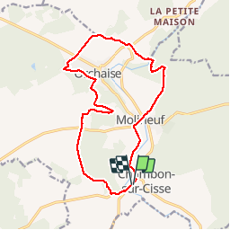
15 km | 18,4 km-effort
3h 45min
Ja
Tocht Mountainbike Valloire-sur-Cisse - Vignoble et Cisse - Chouzy sur Cisse - Photo
Mountainbike
tracegps

Mountainbike

Medium
(2)
Valloire-sur-Cisse, Centre-Val de Loire, Loir-et-Cher, France
18,8 km | 21 km-effort
1h 30min
Ja
Tocht Te voet Valencisse - Chambon-Molineuf par Champigny - Photo
Te voet
gerardbenchetrit

Te voet

Gemakkelijk
(1)
Valencisse, Centre-Val de Loire, Loir-et-Cher, France
14,7 km | 18,1 km-effort
Onbekend
Ja
Tocht Stappen Valloire-sur-Cisse - Seillac - Circuit des Bois - Photo
Stappen
guydu41

Stappen

Gemakkelijk
Valloire-sur-Cisse, Centre-Val de Loire, Loir-et-Cher, France
7,8 km | 8,6 km-effort
1h 53min
Ja
Tocht Stappen Saint-Sulpice-de-Pommeray - Saint-Sulpice-de-Pommeray - Photo
Stappen
guydu41

Stappen

Medium
Saint-Sulpice-de-Pommeray, Centre-Val de Loire, Loir-et-Cher, France
24 km | 29 km-effort
8h 41min
Ja
Tocht Stappen Valloire-sur-Cisse - Randonnée BBR du 18 novembre 2020 - Photo
Stappen
Ecureuiltrailer

Stappen

Heel gemakkelijk
Valloire-sur-Cisse, Centre-Val de Loire, Loir-et-Cher, France
13,8 km | 15,5 km-effort
2h 50min
Ja
Tocht Stappen Valencisse - Circuit n°3 de Molineuf - Photo
Stappen
tracegps

Stappen

Medium
Valencisse, Centre-Val de Loire, Loir-et-Cher, France
12,3 km | 14,6 km-effort
3h 0min
Ja
Tocht Stappen Valencisse - Circuit n°2 de Molineuf - Photo
Stappen
tracegps

Stappen

Medium
Valencisse, Centre-Val de Loire, Loir-et-Cher, France
9 km | 11,6 km-effort
2h 45min
Ja
Tocht Stappen Valencisse - Circuit n°1 de Molineuf  - Photo
Stappen
tracegps

Stappen

Moeilijk
Valencisse, Centre-Val de Loire, Loir-et-Cher, France
16,9 km | 20 km-effort
4h 15min
Ja


Sluiten
Mijn abonnementen