Tocht Stappen Butot - BUTOT - Photo
 PHIL76750
PHIL76750

Gebruiker

© OpenStreetMap contributors
Lengte
Lengte
11,6 km
Max. hoogte
Max. hoogte
175 m
Positief hoogteverschil
129 m
Km-Effort
Km-Effort  
13,3 km
Min. hoogte
Min. hoogte
131 m
Negatief hoogteverschil
128 m
Boucle
Boucle
Ja
Datum van aanmaak :
2019-11-17 07:55:12.213
Laatste wijziging :
2019-11-17 11:11:02.689

(1 Bericht)

Stappen
Stappen
3h14
Moeilijkheid : Heel gemakkelijk

Scan deze QR-code om de tocht te openen in de SityTrail-applicatie

Gratisgps-wandelapplicatie

Logo SityTrail SityTrail

IGN / Geografische instituten

SityTrail uit de App Store downloaden SityTrail uit Google Play downloaden

Logo SityTrail SityTrail World

De wereld gaat voor u open

SityTrail uit de App Store downloaden SityTrail uit Google Play downloaden SityTrail op Huawei AppGallery downloaden

Over ons

Tocht Stappen van 11,6 km beschikbaar op Normandië, Seine-Maritime, Butot. Deze tocht wordt voorgesteld door PHIL76750.

Hoogteprofiel

Plaatsbepaling

Land:
France
Regio :
Normandië
Departement/Provincie :
Seine-Maritime
Gemeente :
Butot
Locatie:
Unknown
Vertrek:(UTM)
357510 ; 5497764 (31U) N.

Opmerkingen

Gelieve in te loggen om een commentaar of een beoordeling achter te laten


Wandeltochten in de omgeving

Tocht Stappen Butot - Butot -76- Chemin de randonnée le BOis de Grosfy - Photo
Stappen
MichelRando7656

Stappen

Moeilijk
Butot, Normandië, Seine-Maritime, France
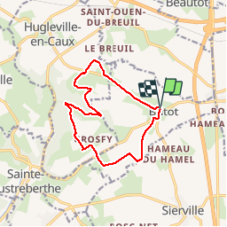
14,5 km | 16,7 km-effort
4h 3min
Ja
Tocht Stappen Clères - Clères - Le Bocasse - V2 - GD - Photo
Stappen
philippe76

Stappen

Medium
(1)
Clères, Normandië, Seine-Maritime, France
9,1 km | 11 km-effort
2h 30min
Neen
Tocht Stappen Goupillières - Goupillieres 6 - Photo
Stappen
francois duparc

Stappen

Gemakkelijk
Goupillières, Normandië, Seine-Maritime, France
6,8 km | 7,6 km-effort
1h 40min
Ja
Tocht Te voet Ancretiéville-Saint-Victor - Du centre de la Seine-Maritime à la découverte de Notre-Dame-de-France - Photo
Te voet
PRO

Te voet

Gemakkelijk
Ancretiéville-Saint-Victor, Normandië, Seine-Maritime, France
10,1 km | 11,2 km-effort
2h 33min
Ja
Tocht Te voet Hugleville-en-Caux - Le Bois de Grofys - Photo
Te voet
PRO

Te voet

Gemakkelijk
Hugleville-en-Caux, Normandië, Seine-Maritime, France
11,6 km | 13,3 km-effort
3h 1min
Ja
Tocht Stappen Sainte-Austreberthe - Ste Austreberthe Pavilly A-R - Photo
Stappen
MichelARRP

Stappen

Moeilijk
Sainte-Austreberthe, Normandië, Seine-Maritime, France
12,5 km | 15,6 km-effort
3h 7min
Ja
Tocht Stappen Varneville-Bretteville - La Bouteillerie - Photo
Stappen

Stappen

Gemakkelijk
Varneville-Bretteville, Normandië, Seine-Maritime, France
12,8 km | 14 km-effort
3h 7min
Ja
Tocht Stappen Ancretiéville-Saint-Victor - ancretieville saint victor - Photo
Stappen
nicole.reine@wanadoo.fr

Stappen

Heel gemakkelijk
Ancretiéville-Saint-Victor, Normandië, Seine-Maritime, France
10,1 km | 11,3 km-effort
2h 32min
Ja
Tocht Stappen Goupillières - goupillères balade - Photo
Stappen
nicole.reine@wanadoo.fr

Stappen

Heel gemakkelijk
(1)
Goupillières, Normandië, Seine-Maritime, France
6,4 km | 7,2 km-effort
1h 36min
Ja


Sluiten
Mijn abonnementen