![](/images/other/stat-length.png)
![Tocht Stappen Arrien-en-Bethmale - 2019-11-02_20h08m35_-6.o - Photo](https://media.geolcdn.com/t/1900/400/ext.pjpeg?maxdim=2&url=https%3A%2F%2Fstatic1.geolcdn.com%2Fsiteimages%2Fupload%2Ffiles%2F1553511878bg_sport_marche.png)
2019-11-02_20h08m35_-6.o
dawed311
Gebruiker
![Lengte](/images/other/stat-length.png)
![Max. hoogte](https://static1.geolcdn.com/siteimages/upload/files/1508320355ic_sort_altitude_max_24dp.png)
![Positief hoogteverschil](https://static1.geolcdn.com/siteimages/upload/files/1508320355ic_sort_den_pos_24dp.png)
![Km-Effort](/images/other/stat-length.png)
![Min. hoogte](https://static1.geolcdn.com/siteimages/upload/files/1508320355ic_sort_altitude_min_24dp.png)
![Negatief hoogteverschil](https://static1.geolcdn.com/siteimages/upload/files/1508320355ic_sort_den_neg_24dp.png)
![Boucle](https://static1.geolcdn.com/siteimages/upload/files/16400158638029165_repeat_loop_refresh_sync_direction_icon.png)
![Stappen](https://static1.geolcdn.com/sitytour/trail-icons/101.png)
7h23
Moeilijkheid : Moeilijk
![Scan deze QR-code om de tocht te openen in de SityTrail-applicatie](https://capi.geolives.com/qq0zvz2zws4bq2lad0pu/sitytour/trails/2256186/qr.png?size=200)
Gratisgps-wandelapplicatie
Over ons
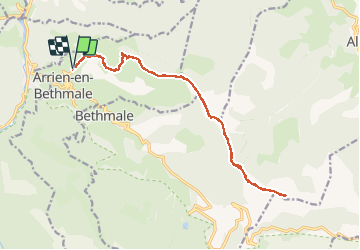
Tocht Stappen van 20 km beschikbaar op Occitanië, Ariège, Arrien-en-Bethmale. Deze tocht wordt voorgesteld door dawed311.
Beschrijving
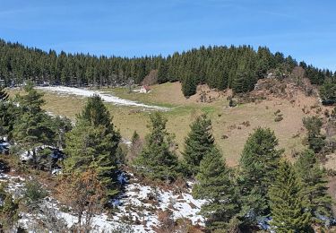
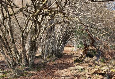
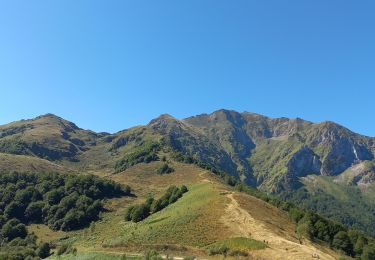
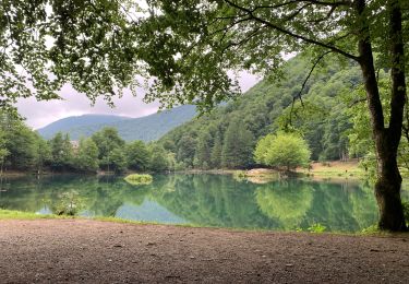
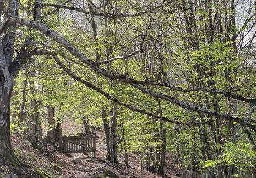
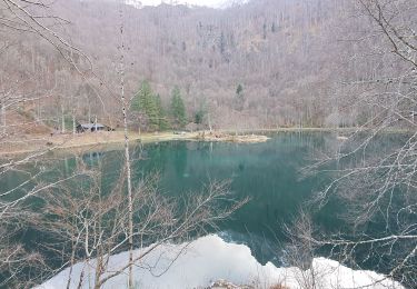
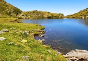
Départ de Villargein histoire de compliquer un sommet facilement accessible depuis le col de la Core. Départ très raide dès le début, puis long chemin de crêtes bien rondouillardes et sans aucun danger. Le lac de Bethmale se fait visible au col de l'Arech, mais il ne se voit plus du Cap de Bouirex. Très joli panorama au sommet avec le Vallier tout proche. Le long retour semble interminable.
Plaatsbepaling
Opmerkingen
Wandeltochten in de omgeving
![Tocht Stappen Arrien-en-Bethmale - Les granges de la Serre depuis Tournac-La Bouche. - Photo](https://media.geolcdn.com/t/375/260/00f09377-3bad-4290-954b-9b185ed107d2.jpg&format=jpg&maxdim=2)
![Stappen Stappen](https://static1.geolcdn.com/sitytour/trail-icons/101.png)
Stappen
![](/images/other/stat-length.png)
![](https://static1.geolcdn.com/siteimages/upload/files/16400158638029165_repeat_loop_refresh_sync_direction_icon.png)
![Tocht Stappen Bethmale - Bethmale - Photo](https://media.geolcdn.com/t/375/260/ext.jpg?maxdim=2&url=https%3A%2F%2Fservices.sitytrail.com%2FGeolivesWS%2FDownloadMedia.ashx%3FTrailID%3D205667%26Media%3Dfix__20130713122146.jpg)
![Stappen Stappen](https://static1.geolcdn.com/sitytour/trail-icons/101.png)
![Tocht Stappen Bethmale - Circuit des cinq étangs (2237m) - Photo](https://media.geolcdn.com/t/375/260/ext.jpg?maxdim=2&url=https%3A%2F%2Fstatic1.geolcdn.com%2Fsiteimages%2Fupload%2Ffiles%2F1553511878bg_sport_marche.png)
![Stappen Stappen](https://static1.geolcdn.com/sitytour/trail-icons/101.png)
Stappen
![](/images/other/stat-length.png)
![](https://static1.geolcdn.com/siteimages/upload/files/16400158638029165_repeat_loop_refresh_sync_direction_icon.png)
![Tocht Stappen Salsein - Cabane et pic de l'Arraing depuis Salsein - Photo](https://media.geolcdn.com/t/375/260/f91c1032-feb4-41d1-b41d-2f82c72f5c13.jpg&format=jpg&maxdim=2)
![Stappen Stappen](https://static1.geolcdn.com/sitytour/trail-icons/101.png)
Stappen
![](/images/other/stat-length.png)
![](https://static1.geolcdn.com/siteimages/upload/files/16400158638029165_repeat_loop_refresh_sync_direction_icon.png)
![Tocht Stappen Bethmale - Cap de Bouirex - Photo](https://media.geolcdn.com/t/375/260/cd5f9d82-9db3-4878-a9ba-18a6e8856ce6.jpg&format=jpg&maxdim=2)
![Stappen Stappen](https://static1.geolcdn.com/sitytour/trail-icons/101.png)
Stappen
![](/images/other/stat-length.png)
![](https://static1.geolcdn.com/siteimages/upload/files/16400158638029165_repeat_loop_refresh_sync_direction_icon.png)
![Tocht Stappen Bethmale - Col de la core - Photo](https://media.geolcdn.com/t/375/260/4994e3ec-bda9-4da3-924c-fcb0e68be84a.jpg&format=jpg&maxdim=2)
![Stappen Stappen](https://static1.geolcdn.com/sitytour/trail-icons/101.png)
Stappen
![](/images/other/stat-length.png)
![](https://static1.geolcdn.com/siteimages/upload/files/16400158638029165_repeat_loop_refresh_sync_direction_icon.png)
![Tocht Stappen Arrien-en-Bethmale - Les granges de la Serre depuis Tournac-Bouche. - Photo](https://media.geolcdn.com/t/375/260/7b3650fc-9802-48da-85b6-ffe6fc31c745.jpg&format=jpg&maxdim=2)
![Stappen Stappen](https://static1.geolcdn.com/sitytour/trail-icons/101.png)
Stappen
![](/images/other/stat-length.png)
![](https://static1.geolcdn.com/siteimages/upload/files/16400158638029165_repeat_loop_refresh_sync_direction_icon.png)
![Tocht Stappen Bethmale - refuge Salvador - Photo](https://media.geolcdn.com/t/375/260/41221468-6f9e-4614-8cc9-9cc4dfd6562d.jpg&format=jpg&maxdim=2)
![Stappen Stappen](https://static1.geolcdn.com/sitytour/trail-icons/101.png)
Stappen
![](/images/other/stat-length.png)
![](https://static1.geolcdn.com/siteimages/upload/files/16400158638029165_repeat_loop_refresh_sync_direction_icon.png)
![Tocht Stappen Sentenac-d'Oust - 2020-08-25 col de la cor - col d'Auédole - étang d'Ayes - col d'Auédole - étang d'Eychelle - col de la core. - Photo](https://media.geolcdn.com/t/375/260/1d8e5b8e-ece0-4a83-9c05-d7dab1c422f8.jpg&format=jpg&maxdim=2)
![Stappen Stappen](https://static1.geolcdn.com/sitytour/trail-icons/101.png)
Stappen
![](/images/other/stat-length.png)
![](https://static1.geolcdn.com/siteimages/upload/files/16400158638029165_repeat_loop_refresh_sync_direction_icon.png)