


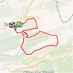

22 km | 28 km-effort


Gebruiker GUIDE


Gratisgps-wandelapplicatie
 SityTrail
IGN / Geografische instituten
SityTrail World
De wereld gaat voor u open
Tocht Stappen van 8 km beschikbaar op Wallonië, Namen, Viroinval. Deze tocht wordt voorgesteld door Desrumaux.
Agréable balade dans la jolie vallée dy Viroin au départ du village de Dourbes jusqu'au ruine du château de Hauteroche.
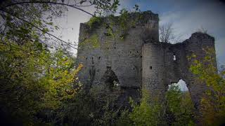
Le vieux Château de Dourbes.


Stappen

Stappen

Fiets

Stappen

Stappen

Mountainbike

Stappen

Noords wandelen
Noords wandelen
9ok