![](/images/other/stat-length.png)
![Tocht Stappen Chamant - Le Château d'eau de Chamant _ 10,6 km - Photo](https://media.geolcdn.com/t/1900/400/ext.pjpeg?maxdim=2&url=https%3A%2F%2Fstatic1.geolcdn.com%2Fsiteimages%2Fupload%2Ffiles%2F1553511878bg_sport_marche.png)
Le Château d'eau de Chamant _ 10,6 km
Pousscailleux
Gebruiker
![Lengte](/images/other/stat-length.png)
![Max. hoogte](https://static1.geolcdn.com/siteimages/upload/files/1508320355ic_sort_altitude_max_24dp.png)
![Positief hoogteverschil](https://static1.geolcdn.com/siteimages/upload/files/1508320355ic_sort_den_pos_24dp.png)
![Km-Effort](/images/other/stat-length.png)
![Min. hoogte](https://static1.geolcdn.com/siteimages/upload/files/1508320355ic_sort_altitude_min_24dp.png)
![Negatief hoogteverschil](https://static1.geolcdn.com/siteimages/upload/files/1508320355ic_sort_den_neg_24dp.png)
![Boucle](https://static1.geolcdn.com/siteimages/upload/files/16400158638029165_repeat_loop_refresh_sync_direction_icon.png)
![Stappen](https://static1.geolcdn.com/sitytour/trail-icons/101.png)
2h41
Moeilijkheid : Gemakkelijk
![Scan deze QR-code om de tocht te openen in de SityTrail-applicatie](https://capi.geolives.com/qq0zvz2zws4bq2lad0pu/sitytour/trails/223908/qr.png?size=200)
Gratisgps-wandelapplicatie
Over ons
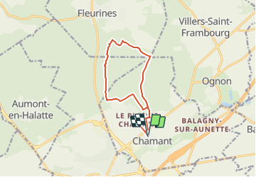
Tocht Stappen van 10,6 km beschikbaar op Hauts-de-France, Oise, Chamant. Deze tocht wordt voorgesteld door Pousscailleux.
Beschrijving
Départ de la Place des écoles à Chamant, rue Eugène Odent (N 49°13'14/E 002°36'39) ou sur le bord de la route de Compiègne (D932A), près du restaurant "A l'Ancien Piqueux" (N 49°13'22/ E 002°36'38).
Seul château d'eau métallique du nord de la France, il a été construit au 19ème siècle vraisemblablement par un élève de Gustave Eiffel. Haut de 30 m, il est constitué d'une cuve en plaques de tôles boulonnées supportée par six piliers en acier laminé. Il est surmonté d'un belvédère. Il a été inscrit aux monuments historiques en 1998.
Albert Menier (celui du chocolat) était propriétaire du Domaine de Chamant qui abritait son écurie de courses. Pour abreuver ses chevaux, il fit ériger dans la forêt d’Halatte ce château d’eau de 30 mètres de haut qui puise l’eau directement dans la nappe phréatique. Il est toujours en activité : il fournit l’eau à Chamant et au Plessis-Chamant.
Plaatsbepaling
Opmerkingen
Wandeltochten in de omgeving
![Tocht Stappen Villers-Saint-Frambourg-Ognon - MR_OGNON (par BALAGNY-sur-AUNETTE)_5.4Km - Photo](https://media.geolcdn.com/t/375/260/faa42a0c-203b-4c6a-9068-84728c6debbe.jpg&format=jpg&maxdim=2)
![Stappen Stappen](https://static1.geolcdn.com/sitytour/trail-icons/101.png)
Stappen
![](/images/other/stat-length.png)
![](https://static1.geolcdn.com/siteimages/upload/files/16400158638029165_repeat_loop_refresh_sync_direction_icon.png)
![Tocht Stappen Senlis - SM_ERMENONVILLE Mais Forest BIAT_7.9Km - Photo](https://media.geolcdn.com/t/375/260/24a0ed61-5581-429f-adcb-b6eee500650a.jpg&format=jpg&maxdim=2)
![Stappen Stappen](https://static1.geolcdn.com/sitytour/trail-icons/101.png)
Stappen
![](/images/other/stat-length.png)
![](https://static1.geolcdn.com/siteimages/upload/files/16400158638029165_repeat_loop_refresh_sync_direction_icon.png)
![Tocht Stappen Mont-l'Évêque - SM_MONT-L'EVEQUE_8Km - Photo](https://media.geolcdn.com/t/375/260/c5d9fe69-6f06-4add-9173-2e50cb01e4b9.jpg&format=jpg&maxdim=2)
![Stappen Stappen](https://static1.geolcdn.com/sitytour/trail-icons/101.png)
Stappen
![](/images/other/stat-length.png)
![](https://static1.geolcdn.com/siteimages/upload/files/16400158638029165_repeat_loop_refresh_sync_direction_icon.png)
![Tocht Stappen Borest - SM_BOREST SUD_8Km - Photo](https://media.geolcdn.com/t/375/260/27f1e0b4-8312-4412-80d8-e928b28ed5d3.jpg&format=jpg&maxdim=2)
![Stappen Stappen](https://static1.geolcdn.com/sitytour/trail-icons/101.png)
Stappen
![](/images/other/stat-length.png)
![](https://static1.geolcdn.com/siteimages/upload/files/16400158638029165_repeat_loop_refresh_sync_direction_icon.png)
![Tocht Stappen Borest - V&D_BOREST-SUD_9.3Km - Photo](https://media.geolcdn.com/t/375/260/dac00e57-fc57-4e0e-8dc5-f670942f21e7.jpg&format=jpg&maxdim=2)
![Stappen Stappen](https://static1.geolcdn.com/sitytour/trail-icons/101.png)
Stappen
![](/images/other/stat-length.png)
![](https://static1.geolcdn.com/siteimages/upload/files/16400158638029165_repeat_loop_refresh_sync_direction_icon.png)
![Tocht Te voet Senlis - SENLIS CITE ROYALE(FFK) - Photo](https://media.geolcdn.com/t/375/260/542124cb-4295-4676-8208-e617d363b61b.jpg&format=jpg&maxdim=2)
![Te voet Te voet](https://static1.geolcdn.com/sitytour/trail-icons/100.png)
Te voet
![](/images/other/stat-length.png)
![](https://static1.geolcdn.com/siteimages/upload/files/16400158638029165_repeat_loop_refresh_sync_direction_icon.png)
![Tocht Stappen Fleurines - Fleurines Grand parcours - Photo](https://media.geolcdn.com/t/375/260/ext.jpg?maxdim=2&url=https%3A%2F%2Fstatic1.geolcdn.com%2Fsiteimages%2Fupload%2Ffiles%2F1553511878bg_sport_marche.png)
![Stappen Stappen](https://static1.geolcdn.com/sitytour/trail-icons/101.png)
Stappen
![](/images/other/stat-length.png)
![](https://static1.geolcdn.com/siteimages/upload/files/16400158638029165_repeat_loop_refresh_sync_direction_icon.png)
![Tocht Stappen Chamant - Chamant Supermini-rando - Photo](https://media.geolcdn.com/t/375/260/ext.jpg?maxdim=2&url=https%3A%2F%2Fstatic1.geolcdn.com%2Fsiteimages%2Fupload%2Ffiles%2F1553511878bg_sport_marche.png)
![Stappen Stappen](https://static1.geolcdn.com/sitytour/trail-icons/101.png)
Stappen
![](/images/other/stat-length.png)
![](https://static1.geolcdn.com/siteimages/upload/files/16400158638029165_repeat_loop_refresh_sync_direction_icon.png)
![Tocht Te voet Senlis - De Orrouy à Coye - Photo](https://media.geolcdn.com/t/375/260/e89a52f7-2fff-43c2-bfe0-60f4f3ab03ed.jpeg&format=jpg&maxdim=2)
![Te voet Te voet](https://static1.geolcdn.com/sitytour/trail-icons/100.png)
Te voet
![](/images/other/stat-length.png)
![](https://static1.geolcdn.com/siteimages/upload/files/16400158638029165_repeat_loop_refresh_sync_direction_icon.png)