![](/images/other/stat-length.png)
![Tocht Stappen Chamant - Le Chêne à l'Image _ 6,8 km - Photo](https://media.geolcdn.com/t/1900/400/ext.pjpeg?maxdim=2&url=https%3A%2F%2Fstatic1.geolcdn.com%2Fsiteimages%2Fupload%2Ffiles%2F1553511878bg_sport_marche.png)
Le Chêne à l'Image _ 6,8 km
Pousscailleux
Gebruiker
![Lengte](/images/other/stat-length.png)
Lengte
6,8 km
![Max. hoogte](https://static1.geolcdn.com/siteimages/upload/files/1508320355ic_sort_altitude_max_24dp.png)
Max. hoogte
182 m
![Positief hoogteverschil](https://static1.geolcdn.com/siteimages/upload/files/1508320355ic_sort_den_pos_24dp.png)
Positief hoogteverschil
115 m
![Km-Effort](/images/other/stat-length.png)
Km-Effort
8,3 km
![Min. hoogte](https://static1.geolcdn.com/siteimages/upload/files/1508320355ic_sort_altitude_min_24dp.png)
Min. hoogte
113 m
![Negatief hoogteverschil](https://static1.geolcdn.com/siteimages/upload/files/1508320355ic_sort_den_neg_24dp.png)
Negatief hoogteverschil
115 m
![Boucle](https://static1.geolcdn.com/siteimages/upload/files/16400158638029165_repeat_loop_refresh_sync_direction_icon.png)
Boucle
Ja
Datum van aanmaak :
2014-12-10 00:00:00.0
Laatste wijziging :
2014-12-10 00:00:00.0
![Stappen](https://static1.geolcdn.com/sitytour/trail-icons/101.png)
1h48
Moeilijkheid : Gemakkelijk
![Scan deze QR-code om de tocht te openen in de SityTrail-applicatie](https://capi.geolives.com/qq0zvz2zws4bq2lad0pu/sitytour/trails/223322/qr.png?size=200)
Gratisgps-wandelapplicatie
Over ons
Tocht Stappen van 6,8 km beschikbaar op Hauts-de-France, Oise, Chamant. Deze tocht wordt voorgesteld door Pousscailleux.
Beschrijving
Départ du parking du Poteau des Blancs Sablons.
Le Chêne à l'Image est un arbre vénéré sur lequel, en haut du tronc, a été installée une reproduction de la Vierge Marie.
Plaatsbepaling
Land:
France
Regio :
Hauts-de-France
Departement/Provincie :
Oise
Gemeente :
Chamant
Locatie:
Unknown
Vertrek:(Dec)
Vertrek:(UTM)
471773 ; 5454834 (31U) N.
Opmerkingen
Wandeltochten in de omgeving
![Tocht Stappen Villers-Saint-Frambourg-Ognon - MR_OGNON (par BALAGNY-sur-AUNETTE)_5.4Km - Photo](https://media.geolcdn.com/t/375/260/faa42a0c-203b-4c6a-9068-84728c6debbe.jpg&format=jpg&maxdim=2)
![Stappen Stappen](https://static1.geolcdn.com/sitytour/trail-icons/101.png)
MR_OGNON (par BALAGNY-sur-AUNETTE)_5.4Km
Stappen
Medium
(3)
Villers-Saint-Frambourg-Ognon,
Hauts-de-France,
Oise,
France
![](/images/other/stat-length.png)
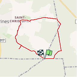
5,4 km | 6,4 km-effort
1h 27min
![](https://static1.geolcdn.com/siteimages/upload/files/16400158638029165_repeat_loop_refresh_sync_direction_icon.png)
Ja
![Tocht Te voet Senlis - SENLIS CITE ROYALE(FFK) - Photo](https://media.geolcdn.com/t/375/260/542124cb-4295-4676-8208-e617d363b61b.jpg&format=jpg&maxdim=2)
![Te voet Te voet](https://static1.geolcdn.com/sitytour/trail-icons/100.png)
SENLIS CITE ROYALE(FFK)
Te voet
Heel gemakkelijk
(1)
Senlis,
Hauts-de-France,
Oise,
France
![](/images/other/stat-length.png)
4,6 km | 5,2 km-effort
2h 0min
![](https://static1.geolcdn.com/siteimages/upload/files/16400158638029165_repeat_loop_refresh_sync_direction_icon.png)
Ja
![Tocht Stappen Fleurines - Fleurines Grand parcours - Photo](https://media.geolcdn.com/t/375/260/ext.jpg?maxdim=2&url=https%3A%2F%2Fstatic1.geolcdn.com%2Fsiteimages%2Fupload%2Ffiles%2F1553511878bg_sport_marche.png)
![Stappen Stappen](https://static1.geolcdn.com/sitytour/trail-icons/101.png)
Fleurines Grand parcours
Stappen
Gemakkelijk
(1)
Fleurines,
Hauts-de-France,
Oise,
France
![](/images/other/stat-length.png)
20 km | 24 km-effort
5h 8min
![](https://static1.geolcdn.com/siteimages/upload/files/16400158638029165_repeat_loop_refresh_sync_direction_icon.png)
Ja
![Tocht Stappen Chamant - Chamant Supermini-rando - Photo](https://media.geolcdn.com/t/375/260/ext.jpg?maxdim=2&url=https%3A%2F%2Fstatic1.geolcdn.com%2Fsiteimages%2Fupload%2Ffiles%2F1553511878bg_sport_marche.png)
![Stappen Stappen](https://static1.geolcdn.com/sitytour/trail-icons/101.png)
Chamant Supermini-rando
Stappen
Gemakkelijk
(8)
Chamant,
Hauts-de-France,
Oise,
France
![](/images/other/stat-length.png)
8 km | 9,3 km-effort
2h 7min
![](https://static1.geolcdn.com/siteimages/upload/files/16400158638029165_repeat_loop_refresh_sync_direction_icon.png)
Ja
![Tocht Stappen Pontpoint - Mont Pagnotte Grand parcours - Photo](https://media.geolcdn.com/t/375/260/ext.jpg?maxdim=2&url=https%3A%2F%2Fstatic1.geolcdn.com%2Fsiteimages%2Fupload%2Ffiles%2F1553511878bg_sport_marche.png)
![Stappen Stappen](https://static1.geolcdn.com/sitytour/trail-icons/101.png)
Mont Pagnotte Grand parcours
Stappen
Medium
(2)
Pontpoint,
Hauts-de-France,
Oise,
France
![](/images/other/stat-length.png)
16,6 km | 22 km-effort
4h 36min
![](https://static1.geolcdn.com/siteimages/upload/files/16400158638029165_repeat_loop_refresh_sync_direction_icon.png)
Ja
![Tocht Hybride fiets Fleurines - randonnée Au5v OT Ccpoh halatte - Photo](https://media.geolcdn.com/t/375/260/e4619b64-6ffd-453c-8063-35f7d7e4513e.jpg&format=jpg&maxdim=2)
![Hybride fiets Hybride fiets](https://static1.geolcdn.com/sitytour/trail-icons/203.png)
randonnée Au5v OT Ccpoh halatte
Hybride fiets
Gemakkelijk
Fleurines,
Hauts-de-France,
Oise,
France
![](/images/other/stat-length.png)
30 km | 35 km-effort
Onbekend
![](https://static1.geolcdn.com/siteimages/upload/files/16400158638029165_repeat_loop_refresh_sync_direction_icon.png)
Ja
![Tocht Te voet Senlis - De Orrouy à Coye - Photo](https://media.geolcdn.com/t/375/260/e89a52f7-2fff-43c2-bfe0-60f4f3ab03ed.jpeg&format=jpg&maxdim=2)
![Te voet Te voet](https://static1.geolcdn.com/sitytour/trail-icons/100.png)
De Orrouy à Coye
Te voet
Gemakkelijk
Senlis,
Hauts-de-France,
Oise,
France
![](/images/other/stat-length.png)
10,1 km | 11,2 km-effort
2h 33min
![](https://static1.geolcdn.com/siteimages/upload/files/16400158638029165_repeat_loop_refresh_sync_direction_icon.png)
Neen
![Tocht Te voet Aumont-en-Halatte - Chemin Royal - Photo](https://media.geolcdn.com/t/375/260/907ab66a-aaa0-42f5-ab5c-59c4bff36344.jpeg&format=jpg&maxdim=2)
![Te voet Te voet](https://static1.geolcdn.com/sitytour/trail-icons/100.png)
Chemin Royal
Te voet
Gemakkelijk
Aumont-en-Halatte,
Hauts-de-France,
Oise,
France
![](/images/other/stat-length.png)
3,5 km | 4 km-effort
54min
![](https://static1.geolcdn.com/siteimages/upload/files/16400158638029165_repeat_loop_refresh_sync_direction_icon.png)
Neen
![Tocht Stappen Villers-Saint-Frambourg-Ognon - SM_OGNON-(ex BALAGNY-sur-AUNETTE)_8.3Km - Photo](https://media.geolcdn.com/t/375/260/8470847c-163d-447b-bdc6-109cb2fcebb6.jpg&format=jpg&maxdim=2)
![Stappen Stappen](https://static1.geolcdn.com/sitytour/trail-icons/101.png)
SM_OGNON-(ex BALAGNY-sur-AUNETTE)_8.3Km
Stappen
Medium
(4)
Villers-Saint-Frambourg-Ognon,
Hauts-de-France,
Oise,
France
![](/images/other/stat-length.png)
8,3 km | 9,6 km-effort
2h 10min
![](https://static1.geolcdn.com/siteimages/upload/files/16400158638029165_repeat_loop_refresh_sync_direction_icon.png)
Ja