Tocht Stappen Vinaròs - RH Playa 1 - Photo
 HAL26
HAL26

Gebruiker

© OpenStreetMap contributors
Lengte
Lengte
8,4 km
Max. hoogte
Max. hoogte
19 m
Positief hoogteverschil
54 m
Km-Effort
Km-Effort  
9,1 km
Min. hoogte
Min. hoogte
-2 m
Negatief hoogteverschil
50 m
Boucle
Boucle
Neen
Datum van aanmaak :
2019-10-14 08:01:32.159
Laatste wijziging :
2019-10-14 12:55:55.977

(0 Bericht)

Stappen
Stappen
4h53
Moeilijkheid : Gemakkelijk

Scan deze QR-code om de tocht te openen in de SityTrail-applicatie

Gratisgps-wandelapplicatie

Logo SityTrail SityTrail

IGN / Geografische instituten

SityTrail uit de App Store downloaden SityTrail uit Google Play downloaden

Logo SityTrail SityTrail World

De wereld gaat voor u open

SityTrail uit de App Store downloaden SityTrail uit Google Play downloaden SityTrail op Huawei AppGallery downloaden

Over ons

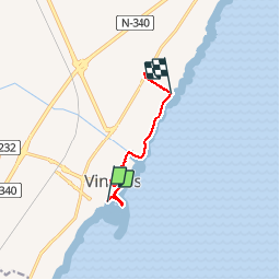
Tocht Stappen van 8,4 km beschikbaar op Valencia, Castelló / Castellón, Vinaròs. Deze tocht wordt voorgesteld door HAL26.

Hoogteprofiel

Plaatsbepaling

Land:
Spain
Regio :
Valencia
Departement/Provincie :
Castelló / Castellón
Gemeente :
Vinaròs
Locatie:
Unknown
Vertrek:(UTM)
285764 ; 4482490 (31T) N.

Wandeltochten in de omgeving

Tocht Stappen Vinaròs - Vinaros 3 - Photo
Stappen
HAL26

Stappen

Gemakkelijk
Vinaròs, Valencia, Castelló / Castellón, Spain
11,1 km | 12,2 km-effort
2h 49min
Ja


Sluiten
Mijn abonnementen