![](/images/other/stat-length.png)
![Tocht Stappen Lège-Cap-Ferret - Lège-Cap Ferret, réserve des près d'Arès 20 km - Photo](https://media.geolcdn.com/t/1900/400/ext.pjpeg?maxdim=2&url=https%3A%2F%2Fstatic1.geolcdn.com%2Fsiteimages%2Fupload%2Ffiles%2F1553511878bg_sport_marche.png)
Lège-Cap Ferret, réserve des près d'Arès 20 km
YV24
Gebruiker
![Lengte](/images/other/stat-length.png)
![Max. hoogte](https://static1.geolcdn.com/siteimages/upload/files/1508320355ic_sort_altitude_max_24dp.png)
![Positief hoogteverschil](https://static1.geolcdn.com/siteimages/upload/files/1508320355ic_sort_den_pos_24dp.png)
![Km-Effort](/images/other/stat-length.png)
![Min. hoogte](https://static1.geolcdn.com/siteimages/upload/files/1508320355ic_sort_altitude_min_24dp.png)
![Negatief hoogteverschil](https://static1.geolcdn.com/siteimages/upload/files/1508320355ic_sort_den_neg_24dp.png)
![Boucle](https://static1.geolcdn.com/siteimages/upload/files/16400158638029165_repeat_loop_refresh_sync_direction_icon.png)
![Stappen](https://static1.geolcdn.com/sitytour/trail-icons/101.png)
6h38
Moeilijkheid : Gemakkelijk
![Scan deze QR-code om de tocht te openen in de SityTrail-applicatie](https://capi.geolives.com/qq0zvz2zws4bq2lad0pu/sitytour/trails/2228057/qr.png?size=200)
Gratisgps-wandelapplicatie
Over ons
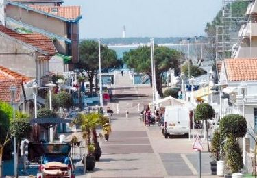
Tocht Stappen van 20 km beschikbaar op Nieuw-Aquitanië, Gironde, Lège-Cap-Ferret. Deze tocht wordt voorgesteld door YV24.
Beschrijving
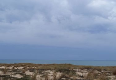
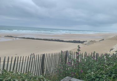
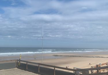
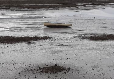
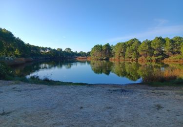
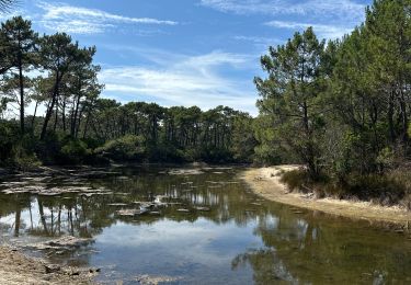
Au départ du VVF de Claouey. Tracé varié combinant le sentier du littoral et d'autres chemins dont la réserve des près salés d'Arès. Parcours agréable, allées sous les pins, sentiers sablonneux, roselières, arbousiers, près salés...
Praticable en tout temps. pour un parcours en sens inverse de la montre, préférez un départ à marée basse, les vues sur le bassin d'Arcachon sont plus sympas. Pique nique possible aux cabanes à huîtres du port d'Arès.
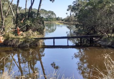
ATTENTION ; en octobre 2019 la passerelle sur le courant de lège est condamnée, ce qui oblige à remonter au giratoire de la D106.
Plaatsbepaling
Opmerkingen
Wandeltochten in de omgeving
![Tocht Hybride fiets Arès - Vélo Arès Cap Feret - Photo](https://media.geolcdn.com/t/375/260/873f7bb6-c81f-4ee5-ac74-bed0238ffe60.jpg&format=jpg&maxdim=2)
![Hybride fiets Hybride fiets](https://static1.geolcdn.com/sitytour/trail-icons/203.png)
Hybride fiets
![](/images/other/stat-length.png)
![](https://static1.geolcdn.com/siteimages/upload/files/16400158638029165_repeat_loop_refresh_sync_direction_icon.png)
![Tocht Elektrische fiets Lège-Cap-Ferret - Sortie Lacanau - Photo](https://media.geolcdn.com/t/375/260/7ed4c728-c115-445a-a435-85386e44651b.jpg&format=jpg&maxdim=2)
![Elektrische fiets Elektrische fiets](https://static1.geolcdn.com/sitytour/trail-icons/205.png)
Elektrische fiets
![](/images/other/stat-length.png)
![](https://static1.geolcdn.com/siteimages/upload/files/16400158638029165_repeat_loop_refresh_sync_direction_icon.png)
![Tocht Elektrische fiets Lège-Cap-Ferret - Le cap feret - Photo](https://media.geolcdn.com/t/375/260/8217cc80-b40e-44d9-800c-e425422724f5.jpg&format=jpg&maxdim=2)
![Elektrische fiets Elektrische fiets](https://static1.geolcdn.com/sitytour/trail-icons/205.png)
Elektrische fiets
![](/images/other/stat-length.png)
![](https://static1.geolcdn.com/siteimages/upload/files/16400158638029165_repeat_loop_refresh_sync_direction_icon.png)
![Tocht Stappen Arès - les prés salés la teste de buch - Photo](https://media.geolcdn.com/t/375/260/fc01b79f-f710-46c8-99b3-a8ce921b7899.jpg&format=jpg&maxdim=2)
![Stappen Stappen](https://static1.geolcdn.com/sitytour/trail-icons/101.png)
Stappen
![](/images/other/stat-length.png)
![](https://static1.geolcdn.com/siteimages/upload/files/16400158638029165_repeat_loop_refresh_sync_direction_icon.png)
![Tocht Fiets Arès - de Ares à Sanguinet - Photo](https://media.geolcdn.com/t/375/260/ext.jpg?maxdim=2&url=https%3A%2F%2Fservices.sitytrail.com%2FGeolivesWS%2FDownloadMedia.ashx%3FTrailID%3D450845%26Media%3D2cca1fec-375e-4780-a004-31cdd349b60d.jpg)
![Fiets Fiets](https://static1.geolcdn.com/sitytour/trail-icons/200.png)
Fiets
![](/images/other/stat-length.png)
![](https://static1.geolcdn.com/siteimages/upload/files/16400158638029165_repeat_loop_refresh_sync_direction_icon.png)
![Tocht Lopen Lège-Cap-Ferret - Solocéan - Photo](https://media.geolcdn.com/t/375/260/64b33a6a-464a-4678-b2a1-70c6bfa068e8.jpg&format=jpg&maxdim=2)
![Lopen Lopen](https://static1.geolcdn.com/sitytour/trail-icons/103.png)
![Tocht Stappen Arès - port ostréicole Ares-Lège - Photo](https://media.geolcdn.com/t/375/260/2a1536ba-8455-407e-9501-1bda7f7191de.jpg&format=jpg&maxdim=2)
![Stappen Stappen](https://static1.geolcdn.com/sitytour/trail-icons/101.png)
Stappen
![](/images/other/stat-length.png)
![](https://static1.geolcdn.com/siteimages/upload/files/16400158638029165_repeat_loop_refresh_sync_direction_icon.png)
![Tocht sport Lège-Cap-Ferret - Réserve naturelle de piraillan - Photo](https://media.geolcdn.com/t/375/260/96eaf589-c926-4bc3-bb46-100f4c4101f7.jpg&format=jpg&maxdim=2)
sport
![](/images/other/stat-length.png)
![](https://static1.geolcdn.com/siteimages/upload/files/16400158638029165_repeat_loop_refresh_sync_direction_icon.png)
![Tocht Stappen Lège-Cap-Ferret - les réservoirs de Piraillan - Photo](https://media.geolcdn.com/t/375/260/7e68497c-ed53-46d0-afd3-a288ec020b2c.jpg&format=jpg&maxdim=2)
![Stappen Stappen](https://static1.geolcdn.com/sitytour/trail-icons/101.png)
Stappen
![](/images/other/stat-length.png)
![](https://static1.geolcdn.com/siteimages/upload/files/16400158638029165_repeat_loop_refresh_sync_direction_icon.png)