![](/images/other/stat-length.png)
![Tocht Mountainbike Villeneuve - Villeneuve 04180 Les cretes et le petit canal - Photo](https://media.geolcdn.com/t/1900/400/ext.pjpeg?maxdim=2&url=https%3A%2F%2Fstatic1.geolcdn.com%2Fsiteimages%2Fupload%2Ffiles%2F1524743154velo.jpg)
Villeneuve 04180 Les cretes et le petit canal
remizzi
Gebruiker
![Lengte](/images/other/stat-length.png)
Lengte
12 km
![Max. hoogte](https://static1.geolcdn.com/siteimages/upload/files/1508320355ic_sort_altitude_max_24dp.png)
Max. hoogte
548 m
![Positief hoogteverschil](https://static1.geolcdn.com/siteimages/upload/files/1508320355ic_sort_den_pos_24dp.png)
Positief hoogteverschil
287 m
![Km-Effort](/images/other/stat-length.png)
Km-Effort
15,8 km
![Min. hoogte](https://static1.geolcdn.com/siteimages/upload/files/1508320355ic_sort_altitude_min_24dp.png)
Min. hoogte
361 m
![Negatief hoogteverschil](https://static1.geolcdn.com/siteimages/upload/files/1508320355ic_sort_den_neg_24dp.png)
Negatief hoogteverschil
287 m
![Boucle](https://static1.geolcdn.com/siteimages/upload/files/16400158638029165_repeat_loop_refresh_sync_direction_icon.png)
Boucle
Ja
Datum van aanmaak :
2019-10-12 13:01:31.415
Laatste wijziging :
2021-04-25 10:30:43.818
![Mountainbike](https://static1.geolcdn.com/sitytour/trail-icons/202.png)
1h17
Moeilijkheid : Medium
![Scan deze QR-code om de tocht te openen in de SityTrail-applicatie](https://capi.geolives.com/qq0zvz2zws4bq2lad0pu/sitytour/trails/2228011/qr.png?size=200)
Gratisgps-wandelapplicatie
Over ons
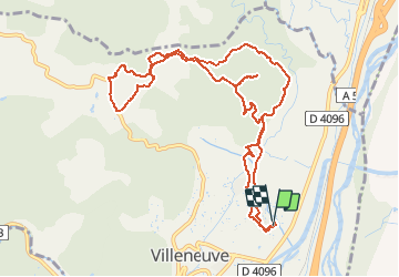
Tocht Mountainbike van 12 km beschikbaar op Provence-Alpes-Côte d'Azur, Alpes-de-Haute-Provence, Villeneuve. Deze tocht wordt voorgesteld door remizzi.
Beschrijving
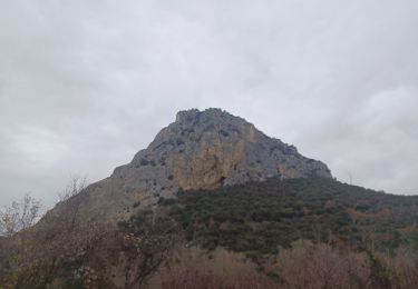
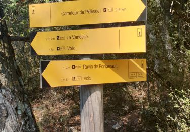
Boucle 1h30 Variée et Belle. Chemin forestier en montée et Sente en Forêt a la descente...
Plaatsbepaling
Land:
France
Regio :
Provence-Alpes-Côte d'Azur
Departement/Provincie :
Alpes-de-Haute-Provence
Gemeente :
Villeneuve
Locatie:
Unknown
Vertrek:(Dec)
Vertrek:(UTM)
730964 ; 4864521 (31T) N.
Opmerkingen
Wandeltochten in de omgeving
![Tocht Stappen Villeneuve - VILLENEUVE La Roche amere , Chapelle notre-dame de la Roche moy n - Photo](https://media.geolcdn.com/t/375/260/78d42f2f-150b-404c-9269-37a1d30b783e.jpg&format=jpg&maxdim=2)
![Stappen Stappen](https://static1.geolcdn.com/sitytour/trail-icons/101.png)
VILLENEUVE La Roche amere , Chapelle notre-dame de la Roche moy n
Stappen
Medium
Villeneuve,
Provence-Alpes-Côte d'Azur,
Alpes-de-Haute-Provence,
France
![](/images/other/stat-length.png)
13,1 km | 18,2 km-effort
4h 38min
![](https://static1.geolcdn.com/siteimages/upload/files/16400158638029165_repeat_loop_refresh_sync_direction_icon.png)
Ja
![Tocht Mountainbike Volx - Volx/Montaigu/Bellevue/La Garde - Photo](https://media.geolcdn.com/t/375/260/ext.jpg?maxdim=2&url=https%3A%2F%2Fstatic1.geolcdn.com%2Fsiteimages%2Fupload%2Ffiles%2F1524743154velo.jpg)
![Mountainbike Mountainbike](https://static1.geolcdn.com/sitytour/trail-icons/202.png)
Volx/Montaigu/Bellevue/La Garde
Mountainbike
Medium
(1)
Volx,
Provence-Alpes-Côte d'Azur,
Alpes-de-Haute-Provence,
France
![](/images/other/stat-length.png)
16,2 km | 24 km-effort
1h 33min
![](https://static1.geolcdn.com/siteimages/upload/files/16400158638029165_repeat_loop_refresh_sync_direction_icon.png)
Ja
![Tocht Stappen Villeneuve - VILLENEUVE. NOTRE-DAME DE LA ROCHE O L S - Photo](https://media.geolcdn.com/t/375/260/e12c610c-f05d-407f-8a61-1557f236cc62.jpg&format=jpg&maxdim=2)
![Stappen Stappen](https://static1.geolcdn.com/sitytour/trail-icons/101.png)
VILLENEUVE. NOTRE-DAME DE LA ROCHE O L S
Stappen
Medium
Villeneuve,
Provence-Alpes-Côte d'Azur,
Alpes-de-Haute-Provence,
France
![](/images/other/stat-length.png)
16,1 km | 23 km-effort
4h 25min
![](https://static1.geolcdn.com/siteimages/upload/files/16400158638029165_repeat_loop_refresh_sync_direction_icon.png)
Ja
![Tocht Stappen Oraison - ORAISON . CHAPELLE S PANCRACE . LES BUISSONADES N - Photo](https://media.geolcdn.com/t/375/260/3d79a10d-f1d4-42a2-bd87-6509734b6c65.jpg&format=jpg&maxdim=2)
![Stappen Stappen](https://static1.geolcdn.com/sitytour/trail-icons/101.png)
ORAISON . CHAPELLE S PANCRACE . LES BUISSONADES N
Stappen
Medium
Oraison,
Provence-Alpes-Côte d'Azur,
Alpes-de-Haute-Provence,
France
![](/images/other/stat-length.png)
15,2 km | 18,5 km-effort
3h 58min
![](https://static1.geolcdn.com/siteimages/upload/files/16400158638029165_repeat_loop_refresh_sync_direction_icon.png)
Ja
![Tocht Stappen Oraison - oraison autour d'Aurėlie - Photo](https://media.geolcdn.com/t/375/260/ext.jpg?maxdim=2&url=https%3A%2F%2Fstatic1.geolcdn.com%2Fsiteimages%2Fupload%2Ffiles%2F1553511878bg_sport_marche.png)
![Stappen Stappen](https://static1.geolcdn.com/sitytour/trail-icons/101.png)
oraison autour d'Aurėlie
Stappen
Medium
(1)
Oraison,
Provence-Alpes-Côte d'Azur,
Alpes-de-Haute-Provence,
France
![](/images/other/stat-length.png)
6,6 km | 7,6 km-effort
1h 43min
![](https://static1.geolcdn.com/siteimages/upload/files/16400158638029165_repeat_loop_refresh_sync_direction_icon.png)
Ja
![Tocht Stappen Oraison - 2023-01-13 Oraison - La Baume - Photo](https://media.geolcdn.com/t/375/260/85a17eb6-1fbb-40b0-9fb5-584a9231d587.jpg&format=jpg&maxdim=2)
![Stappen Stappen](https://static1.geolcdn.com/sitytour/trail-icons/101.png)
2023-01-13 Oraison - La Baume
Stappen
Heel gemakkelijk
Oraison,
Provence-Alpes-Côte d'Azur,
Alpes-de-Haute-Provence,
France
![](/images/other/stat-length.png)
13,8 km | 18,6 km-effort
6h 38min
![](https://static1.geolcdn.com/siteimages/upload/files/16400158638029165_repeat_loop_refresh_sync_direction_icon.png)
Ja
![Tocht Stappen Volx - VOLX . TOUR DE LA ROCHE AMÈRE 0 L M - Photo](https://media.geolcdn.com/t/375/260/6872c8a4-7e66-489f-a2b2-1aad1480f59e.jpg&format=jpg&maxdim=2)
![Stappen Stappen](https://static1.geolcdn.com/sitytour/trail-icons/101.png)
VOLX . TOUR DE LA ROCHE AMÈRE 0 L M
Stappen
Gemakkelijk
Volx,
Provence-Alpes-Côte d'Azur,
Alpes-de-Haute-Provence,
France
![](/images/other/stat-length.png)
12,7 km | 17,3 km-effort
3h 34min
![](https://static1.geolcdn.com/siteimages/upload/files/16400158638029165_repeat_loop_refresh_sync_direction_icon.png)
Ja
![Tocht Stappen Volx - VOLX . CRETES DE VOLX O L M - Photo](https://media.geolcdn.com/t/375/260/33e323f9-3969-4d23-a293-27950b255122.jpg&format=jpg&maxdim=2)
![Stappen Stappen](https://static1.geolcdn.com/sitytour/trail-icons/101.png)
VOLX . CRETES DE VOLX O L M
Stappen
Moeilijk
Volx,
Provence-Alpes-Côte d'Azur,
Alpes-de-Haute-Provence,
France
![](/images/other/stat-length.png)
15,2 km | 24 km-effort
5h 38min
![](https://static1.geolcdn.com/siteimages/upload/files/16400158638029165_repeat_loop_refresh_sync_direction_icon.png)
Ja
![Tocht Trail Volx - volx - Photo](https://media.geolcdn.com/t/375/260/074b6f13-4b46-4d5f-9210-d6f66b960796.jpg&format=jpg&maxdim=2)
![Trail Trail](https://static1.geolcdn.com/sitytour/trail-icons/104.png)
volx
Trail
Moeilijk
Volx,
Provence-Alpes-Côte d'Azur,
Alpes-de-Haute-Provence,
France
![](/images/other/stat-length.png)
9,2 km | 14,7 km-effort
1h 43min
![](https://static1.geolcdn.com/siteimages/upload/files/16400158638029165_repeat_loop_refresh_sync_direction_icon.png)
Ja