![](/images/other/stat-length.png)
![Tocht Paardrijden La Roche-sur-le-Buis - SityTrail - J3 lievre reilhanette 24k - Photo](https://media.geolcdn.com/t/1900/400/ext.pjpeg?maxdim=2&url=https%3A%2F%2Fstatic1.geolcdn.com%2Fsiteimages%2Fupload%2Ffiles%2F1524743154cheval.jpg)
SityTrail - J3 lievre reilhanette 24k
Helleni
Gebruiker
![Lengte](/images/other/stat-length.png)
![Max. hoogte](https://static1.geolcdn.com/siteimages/upload/files/1508320355ic_sort_altitude_max_24dp.png)
![Positief hoogteverschil](https://static1.geolcdn.com/siteimages/upload/files/1508320355ic_sort_den_pos_24dp.png)
![Km-Effort](/images/other/stat-length.png)
![Min. hoogte](https://static1.geolcdn.com/siteimages/upload/files/1508320355ic_sort_altitude_min_24dp.png)
![Negatief hoogteverschil](https://static1.geolcdn.com/siteimages/upload/files/1508320355ic_sort_den_neg_24dp.png)
![Boucle](https://static1.geolcdn.com/siteimages/upload/files/16400158638029165_repeat_loop_refresh_sync_direction_icon.png)
![Paardrijden](https://static1.geolcdn.com/sitytour/trail-icons/301.png)
4h04
Moeilijkheid : Medium
![Scan deze QR-code om de tocht te openen in de SityTrail-applicatie](https://capi.geolives.com/qq0zvz2zws4bq2lad0pu/sitytour/trails/2223594/qr.png?size=200)
Gratisgps-wandelapplicatie
Over ons
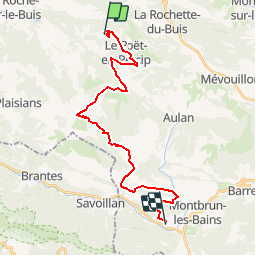
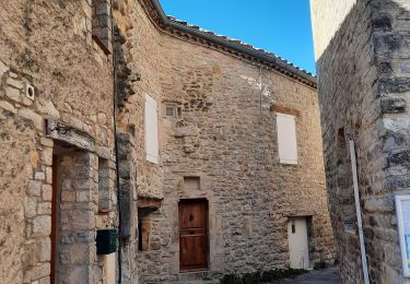
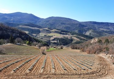
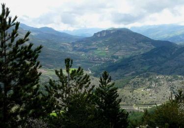
Tocht Paardrijden van 24 km beschikbaar op Auvergne-Rhône-Alpes, Drôme, La Roche-sur-le-Buis. Deze tocht wordt voorgesteld door Helleni.
Beschrijving
Le Tour Equestre GRP Pays de Dieulefit-Bourdeaux Il peut se faire dans sa totalité, de façon itinérante, par étape ou ponctuellement sur une partie du tracé. Des variantes existent permettant de modifier le circuit. Des variantes sont également disponibles au format .gpx sur simple demande. LE BALISAGE Conforme au cahier des charges de balisage de la FFE/CNTE, le tour équestre est marqué en orange. NB : Lorsque le tour équestre emprunte les étapes Mornans - Truinas, il est balisé en orange et bleu (Tradac Drôme à Cheval). Référence cartes IGN échelle 1/25 000 : 3038 E, 3138 OT, 3139 OT
Plaatsbepaling
Opmerkingen
Wandeltochten in de omgeving
![Tocht Stappen Le Poët-en-Percip - Le Poèt du Bout du Monde - Photo](https://media.geolcdn.com/t/375/260/1569e818-5455-4f23-8c9a-380b223c1c41.jpg&format=jpg&maxdim=2)
![Stappen Stappen](https://static1.geolcdn.com/sitytour/trail-icons/101.png)
Stappen
![](/images/other/stat-length.png)
![](https://static1.geolcdn.com/siteimages/upload/files/16400158638029165_repeat_loop_refresh_sync_direction_icon.png)
![Tocht Stappen Aulan - 26 Aulan Poët en Percip - Photo](https://media.geolcdn.com/t/375/260/46c7bb6d-0b90-4bb1-97bc-ec1d2b520019.jpg&format=jpg&maxdim=2)
![Stappen Stappen](https://static1.geolcdn.com/sitytour/trail-icons/101.png)
Stappen
![](/images/other/stat-length.png)
![](https://static1.geolcdn.com/siteimages/upload/files/16400158638029165_repeat_loop_refresh_sync_direction_icon.png)
![Tocht Stappen Sainte-Euphémie-sur-Ouvèze - 2024-04-21_15h22m31_26 Buis Petites-gorges-Ouvèze - Photo](https://media.geolcdn.com/t/375/260/50a924fc-c264-4be9-b1ba-9f2ef1fb0486.jpg&format=jpg&maxdim=2)
![Stappen Stappen](https://static1.geolcdn.com/sitytour/trail-icons/101.png)
Stappen
![](/images/other/stat-length.png)
![](https://static1.geolcdn.com/siteimages/upload/files/16400158638029165_repeat_loop_refresh_sync_direction_icon.png)
![Tocht Stappen Sainte-Euphémie-sur-Ouvèze - Ste Euphémie- sur - Ouvéze 16 km. - Photo](https://media.geolcdn.com/t/375/260/01bea523-f1d0-4b3c-9ab3-81b6eb4ca226.jpg&format=jpg&maxdim=2)
![Stappen Stappen](https://static1.geolcdn.com/sitytour/trail-icons/101.png)
Stappen
![](/images/other/stat-length.png)
![](https://static1.geolcdn.com/siteimages/upload/files/16400158638029165_repeat_loop_refresh_sync_direction_icon.png)
![Tocht Stappen Sainte-Euphémie-sur-Ouvèze - Ste Euphémie sur Ouvèze 15km - Photo](https://media.geolcdn.com/t/375/260/01620b9d-d313-4510-93cc-66e82aefda56.jpg&format=jpg&maxdim=2)
![Stappen Stappen](https://static1.geolcdn.com/sitytour/trail-icons/101.png)
Stappen
![](/images/other/stat-length.png)
![](https://static1.geolcdn.com/siteimages/upload/files/16400158638029165_repeat_loop_refresh_sync_direction_icon.png)
![Mountainbike Mountainbike](https://static1.geolcdn.com/sitytour/trail-icons/202.png)
Mountainbike
![](/images/other/stat-length.png)
![](https://static1.geolcdn.com/siteimages/upload/files/16400158638029165_repeat_loop_refresh_sync_direction_icon.png)
![Tocht Stappen La Roche-sur-le-Buis - Tour de Bridons - Photo](https://media.geolcdn.com/t/375/260/ext.jpg?maxdim=2&url=https%3A%2F%2Fstatic1.geolcdn.com%2Fsiteimages%2Fupload%2Ffiles%2F1553511878bg_sport_marche.png)
![Stappen Stappen](https://static1.geolcdn.com/sitytour/trail-icons/101.png)
Stappen
![](/images/other/stat-length.png)
![](https://static1.geolcdn.com/siteimages/upload/files/16400158638029165_repeat_loop_refresh_sync_direction_icon.png)
![Tocht Stappen Plaisians - De Plaisians à Brantes - Photo](https://media.geolcdn.com/t/375/260/ext.jpg?maxdim=2&url=https%3A%2F%2Fservices.sitytrail.com%2FGeolivesWS%2FDownloadMedia.ashx%3FTrailID%3D105349%26Media%3D9051_1.jpg)
![Stappen Stappen](https://static1.geolcdn.com/sitytour/trail-icons/101.png)
Stappen
![](/images/other/stat-length.png)
![](https://static1.geolcdn.com/siteimages/upload/files/16400158638029165_repeat_loop_refresh_sync_direction_icon.png)
![Tocht Stappen Le Poët-en-Percip - Le Poët en Percip - Aulan - Montagne de la Bohémienne - Photo](https://media.geolcdn.com/t/375/260/ext.jpg?maxdim=2&url=https%3A%2F%2Fservices.sitytrail.com%2FGeolivesWS%2FDownloadMedia.ashx%3FTrailID%3D105312%26Media%3D9003_3.jpg)
![Stappen Stappen](https://static1.geolcdn.com/sitytour/trail-icons/101.png)
Stappen
![](/images/other/stat-length.png)
![](https://static1.geolcdn.com/siteimages/upload/files/16400158638029165_repeat_loop_refresh_sync_direction_icon.png)