![](/images/other/stat-length.png)
![Tocht Stappen Blegny - Blégny _ Domaine Touristique de Blégny-Mine - Photo](https://media.geolcdn.com/t/1900/400/e4d5161c-1dd2-4153-98e8-4fe3c65b2f7f.jpg&format=pjpeg&maxdim=2)
Blégny _ Domaine Touristique de Blégny-Mine
jeangulu
Gebruiker
![Lengte](/images/other/stat-length.png)
Lengte
22 km
![Max. hoogte](https://static1.geolcdn.com/siteimages/upload/files/1508320355ic_sort_altitude_max_24dp.png)
Max. hoogte
276 m
![Positief hoogteverschil](https://static1.geolcdn.com/siteimages/upload/files/1508320355ic_sort_den_pos_24dp.png)
Positief hoogteverschil
313 m
![Km-Effort](/images/other/stat-length.png)
Km-Effort
26 km
![Min. hoogte](https://static1.geolcdn.com/siteimages/upload/files/1508320355ic_sort_altitude_min_24dp.png)
Min. hoogte
149 m
![Negatief hoogteverschil](https://static1.geolcdn.com/siteimages/upload/files/1508320355ic_sort_den_neg_24dp.png)
Negatief hoogteverschil
313 m
![Boucle](https://static1.geolcdn.com/siteimages/upload/files/16400158638029165_repeat_loop_refresh_sync_direction_icon.png)
Boucle
Ja
Datum van aanmaak :
2019-10-05 08:24:55.834
Laatste wijziging :
2019-10-05 14:58:50.723
![Stappen](https://static1.geolcdn.com/sitytour/trail-icons/101.png)
5h21
Moeilijkheid : Medium
![Scan deze QR-code om de tocht te openen in de SityTrail-applicatie](https://capi.geolives.com/qq0zvz2zws4bq2lad0pu/sitytour/trails/2222512/qr.png?size=200)
Gratisgps-wandelapplicatie
Over ons
Tocht Stappen van 22 km beschikbaar op Wallonië, Luik, Blegny. Deze tocht wordt voorgesteld door jeangulu.
Beschrijving
Mortier C'est L'Pied _ LG 176
Très beau parcours beaucoup des routes malheureusement mais beaucoup des chemins de prairies à refaire malgré tout
Plaatsbepaling
Land:
Belgium
Regio :
Wallonië
Departement/Provincie :
Luik
Gemeente :
Blegny
Locatie:
Trembleur
Vertrek:(Dec)
Vertrek:(UTM)
692282 ; 5618426 (31U) N.
Opmerkingen
Wandeltochten in de omgeving
![Tocht Stappen Dalhem - dalhem Bombaye aubin mortroux dalhem - Photo](https://media.geolcdn.com/t/375/260/16a64587-f39e-4282-a4fc-c52e1169e4ec.jpg&format=jpg&maxdim=2)
![Stappen Stappen](https://static1.geolcdn.com/sitytour/trail-icons/101.png)
dalhem Bombaye aubin mortroux dalhem
Stappen
Gemakkelijk
(5)
Dalhem,
Wallonië,
Luik,
Belgium
![](/images/other/stat-length.png)
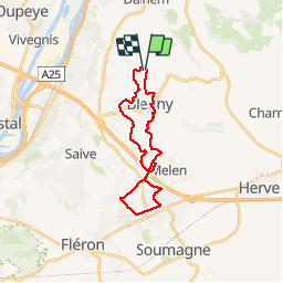
10,9 km | 12,6 km-effort
2h 40min
![](https://static1.geolcdn.com/siteimages/upload/files/16400158638029165_repeat_loop_refresh_sync_direction_icon.png)
Ja
![Tocht Stappen Dalhem - dalhem tunnel . nelhain . la tombe . la folie. dalhrm - Photo](https://media.geolcdn.com/t/375/260/69f57071-dca8-4a6e-ab63-e929cdeb9e89.jpg&format=jpg&maxdim=2)
![Stappen Stappen](https://static1.geolcdn.com/sitytour/trail-icons/101.png)
dalhem tunnel . nelhain . la tombe . la folie. dalhrm
Stappen
Heel gemakkelijk
(7)
Dalhem,
Wallonië,
Luik,
Belgium
![](/images/other/stat-length.png)
8,9 km | 10,6 km-effort
2h 3min
![](https://static1.geolcdn.com/siteimages/upload/files/16400158638029165_repeat_loop_refresh_sync_direction_icon.png)
Ja
![Tocht Stappen Herve - Entre bois et GR (8km) - Photo](https://media.geolcdn.com/t/375/260/ext.jpg?maxdim=2&url=https%3A%2F%2Fstatic1.geolcdn.com%2Fsiteimages%2Fupload%2Ffiles%2F1553511878bg_sport_marche.png)
![Stappen Stappen](https://static1.geolcdn.com/sitytour/trail-icons/101.png)
Entre bois et GR (8km)
Stappen
Heel gemakkelijk
(5)
Herve,
Wallonië,
Luik,
Belgium
![](/images/other/stat-length.png)
7,7 km | 10,1 km-effort
Onbekend
![](https://static1.geolcdn.com/siteimages/upload/files/16400158638029165_repeat_loop_refresh_sync_direction_icon.png)
Ja
![Tocht Stappen Wezet - 2024-06-16_18h10m24_1489.gpx.xml - Photo](https://media.geolcdn.com/t/375/260/d0453d3e-7a76-47f8-90f9-7c05ed843e1f.jpg&format=jpg&maxdim=2)
![Stappen Stappen](https://static1.geolcdn.com/sitytour/trail-icons/101.png)
2024-06-16_18h10m24_1489.gpx.xml
Stappen
Medium
(1)
Wezet,
Wallonië,
Luik,
Belgium
![](/images/other/stat-length.png)
9,3 km | 11,5 km-effort
2h 36min
![](https://static1.geolcdn.com/siteimages/upload/files/16400158638029165_repeat_loop_refresh_sync_direction_icon.png)
Ja
![Tocht Stappen Blegny - 2023-07-28_14h00m33_1702.gpx.xml - Photo](https://media.geolcdn.com/t/375/260/08e717c2-a47c-47f0-9a4e-fb7b564b3f18.jpg&format=jpg&maxdim=2)
![Stappen Stappen](https://static1.geolcdn.com/sitytour/trail-icons/101.png)
2023-07-28_14h00m33_1702.gpx.xml
Stappen
Gemakkelijk
(1)
Blegny,
Wallonië,
Luik,
Belgium
![](/images/other/stat-length.png)
9,9 km | 11,8 km-effort
2h 40min
![](https://static1.geolcdn.com/siteimages/upload/files/16400158638029165_repeat_loop_refresh_sync_direction_icon.png)
Ja
![Tocht Stappen Blegny - 20230703 - Blegny-Mine 6.8 Km - Photo](https://media.geolcdn.com/t/375/260/840a4c96-62cb-4388-9c6c-d720f9bd1cc9.jpeg&format=jpg&maxdim=2)
![Stappen Stappen](https://static1.geolcdn.com/sitytour/trail-icons/101.png)
20230703 - Blegny-Mine 6.8 Km
Stappen
Medium
(1)
Blegny,
Wallonië,
Luik,
Belgium
![](/images/other/stat-length.png)
6,8 km | 8,6 km-effort
2h 8min
![](https://static1.geolcdn.com/siteimages/upload/files/16400158638029165_repeat_loop_refresh_sync_direction_icon.png)
Ja
![Tocht Stappen Wezet - Domaine de la Julienne - Photo](https://media.geolcdn.com/t/375/260/5e4777ba-1a15-488d-98c7-dac2d98d32bb.jpg&format=jpg&maxdim=2)
![Stappen Stappen](https://static1.geolcdn.com/sitytour/trail-icons/101.png)
Domaine de la Julienne
Stappen
Gemakkelijk
(1)
Wezet,
Wallonië,
Luik,
Belgium
![](/images/other/stat-length.png)
7,3 km | 9,5 km-effort
2h 9min
![](https://static1.geolcdn.com/siteimages/upload/files/16400158638029165_repeat_loop_refresh_sync_direction_icon.png)
Ja
![Stappen Stappen](https://static1.geolcdn.com/sitytour/trail-icons/101.png)
20220919 - Herve 6 Km
Stappen
Medium
(1)
Herve,
Wallonië,
Luik,
Belgium
![](/images/other/stat-length.png)
6 km | 7,3 km-effort
1h 44min
![](https://static1.geolcdn.com/siteimages/upload/files/16400158638029165_repeat_loop_refresh_sync_direction_icon.png)
Ja
![Stappen Stappen](https://static1.geolcdn.com/sitytour/trail-icons/101.png)
20220603 - Herve 6.1 Km
Stappen
Medium
(1)
Herve,
Wallonië,
Luik,
Belgium
![](/images/other/stat-length.png)
6,2 km | 7,5 km-effort
1h 38min
![](https://static1.geolcdn.com/siteimages/upload/files/16400158638029165_repeat_loop_refresh_sync_direction_icon.png)
Ja