![](/images/other/stat-length.png)
![Tocht Stappen Saint-Cyr-la-Rosière - Ste Gauburge 17 - Photo](https://media.geolcdn.com/t/1900/400/ext.pjpeg?maxdim=2&url=https%3A%2F%2Fstatic1.geolcdn.com%2Fsiteimages%2Fupload%2Ffiles%2F1553511878bg_sport_marche.png)
Ste Gauburge 17
togolo28
Gebruiker
![Lengte](/images/other/stat-length.png)
Lengte
16,5 km
![Max. hoogte](https://static1.geolcdn.com/siteimages/upload/files/1508320355ic_sort_altitude_max_24dp.png)
Max. hoogte
226 m
![Positief hoogteverschil](https://static1.geolcdn.com/siteimages/upload/files/1508320355ic_sort_den_pos_24dp.png)
Positief hoogteverschil
274 m
![Km-Effort](/images/other/stat-length.png)
Km-Effort
20 km
![Min. hoogte](https://static1.geolcdn.com/siteimages/upload/files/1508320355ic_sort_altitude_min_24dp.png)
Min. hoogte
119 m
![Negatief hoogteverschil](https://static1.geolcdn.com/siteimages/upload/files/1508320355ic_sort_den_neg_24dp.png)
Negatief hoogteverschil
274 m
![Boucle](https://static1.geolcdn.com/siteimages/upload/files/16400158638029165_repeat_loop_refresh_sync_direction_icon.png)
Boucle
Ja
Datum van aanmaak :
2014-12-10 00:00:00.0
Laatste wijziging :
2020-02-24 17:17:14.173
![Stappen](https://static1.geolcdn.com/sitytour/trail-icons/101.png)
4h32
Moeilijkheid : Gemakkelijk
![Scan deze QR-code om de tocht te openen in de SityTrail-applicatie](https://capi.geolives.com/qq0zvz2zws4bq2lad0pu/sitytour/trails/221497/qr.png?size=200)
Gratisgps-wandelapplicatie
Over ons
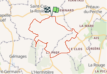
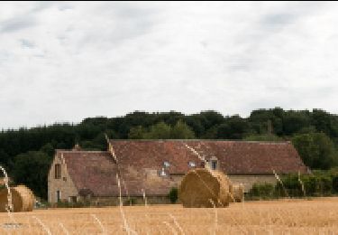
Tocht Stappen van 16,5 km beschikbaar op Normandië, Orne, Saint-Cyr-la-Rosière. Deze tocht wordt voorgesteld door togolo28.
Beschrijving
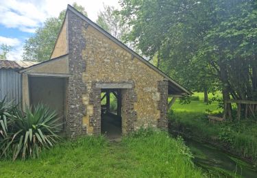
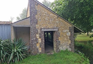
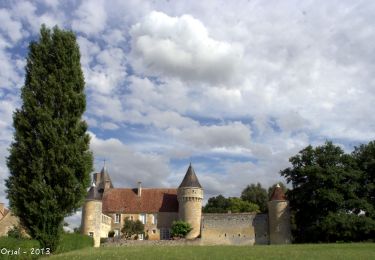
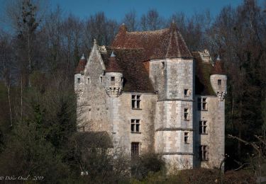
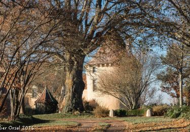
De très beaux manoirs et demeures à admirer au cours de cette randonnée.
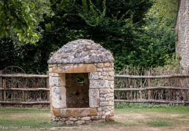
A l'arrivée, vous pouvez en profiter pour visiter l'Eco Musée du Perche.
Plaatsbepaling
Land:
France
Regio :
Normandië
Departement/Provincie :
Orne
Gemeente :
Saint-Cyr-la-Rosière
Locatie:
Unknown
Vertrek:(Dec)
Vertrek:(UTM)
326172 ; 5355032 (31U) N.
Opmerkingen
Wandeltochten in de omgeving
![Tocht Stappen Perche en Nocé - Préaux-du-Perche Nord - Photo](https://media.geolcdn.com/t/375/260/a79e2268-207b-49cb-8d2a-d633dd57f73d.jpg&format=jpg&maxdim=2)
![Stappen Stappen](https://static1.geolcdn.com/sitytour/trail-icons/101.png)
Préaux-du-Perche Nord
Stappen
Gemakkelijk
(1)
Perche en Nocé,
Normandië,
Orne,
France
![](/images/other/stat-length.png)
11,3 km | 13,2 km-effort
2h 59min
![](https://static1.geolcdn.com/siteimages/upload/files/16400158638029165_repeat_loop_refresh_sync_direction_icon.png)
Ja
![Tocht Stappen La Chapelle-Souëf - La Chapelle Souef - Les Feugerets 12 Km - Photo](https://media.geolcdn.com/t/375/260/ext.jpg?maxdim=2&url=https%3A%2F%2Fstatic1.geolcdn.com%2Fsiteimages%2Fupload%2Ffiles%2F1553511878bg_sport_marche.png)
![Stappen Stappen](https://static1.geolcdn.com/sitytour/trail-icons/101.png)
La Chapelle Souef - Les Feugerets 12 Km
Stappen
Medium
(1)
La Chapelle-Souëf,
Normandië,
Orne,
France
![](/images/other/stat-length.png)
12 km | 14,1 km-effort
3h 6min
![](https://static1.geolcdn.com/siteimages/upload/files/16400158638029165_repeat_loop_refresh_sync_direction_icon.png)
Ja
![Tocht Stappen Perche en Nocé - Préaux-du-Perche Sud - Photo](https://media.geolcdn.com/t/375/260/0969c1bf-78c8-4ceb-9cf9-65ed34443adf.jpg&format=jpg&maxdim=2)
![Stappen Stappen](https://static1.geolcdn.com/sitytour/trail-icons/101.png)
Préaux-du-Perche Sud
Stappen
Medium
Perche en Nocé,
Normandië,
Orne,
France
![](/images/other/stat-length.png)
7,9 km | 9,5 km-effort
2h 9min
![](https://static1.geolcdn.com/siteimages/upload/files/16400158638029165_repeat_loop_refresh_sync_direction_icon.png)
Ja
![Tocht Stappen Saint-Cyr-la-Rosière - Au fil de la Rosière 7,1 Km - Photo](https://media.geolcdn.com/t/375/260/6ffb02c5-f518-43cf-b25f-e24d8f031465.jpg&format=jpg&maxdim=2)
![Stappen Stappen](https://static1.geolcdn.com/sitytour/trail-icons/101.png)
Au fil de la Rosière 7,1 Km
Stappen
Medium
Saint-Cyr-la-Rosière,
Normandië,
Orne,
France
![](/images/other/stat-length.png)
7,1 km | 8,7 km-effort
1h 57min
![](https://static1.geolcdn.com/siteimages/upload/files/16400158638029165_repeat_loop_refresh_sync_direction_icon.png)
Ja
![Tocht Stappen Perche en Nocé - Nocé-Courboyer - Saint-Aubin-des-Grois 9,5 km - Photo](https://media.geolcdn.com/t/375/260/74d7cd8d-75a9-4a6d-8570-ba2a55254fab.jpg&format=jpg&maxdim=2)
![Stappen Stappen](https://static1.geolcdn.com/sitytour/trail-icons/101.png)
Nocé-Courboyer - Saint-Aubin-des-Grois 9,5 km
Stappen
Gemakkelijk
Perche en Nocé,
Normandië,
Orne,
France
![](/images/other/stat-length.png)
9,5 km | 11,2 km-effort
2h 25min
![](https://static1.geolcdn.com/siteimages/upload/files/16400158638029165_repeat_loop_refresh_sync_direction_icon.png)
Neen
![Tocht Stappen Perche en Nocé - Val d'Enfer 17Km - Photo](https://media.geolcdn.com/t/375/260/285f82a6-4b4a-437a-b428-48270f65e19b.jpg&format=jpg&maxdim=2)
![Stappen Stappen](https://static1.geolcdn.com/sitytour/trail-icons/101.png)
Val d'Enfer 17Km
Stappen
Medium
Perche en Nocé,
Normandië,
Orne,
France
![](/images/other/stat-length.png)
16,7 km | 19,5 km-effort
4h 16min
![](https://static1.geolcdn.com/siteimages/upload/files/16400158638029165_repeat_loop_refresh_sync_direction_icon.png)
Ja
![Tocht Stappen Perche en Nocé - Nobles logis (Préaux-du-Perche) 9,4Km - Photo](https://media.geolcdn.com/t/375/260/4db8b454-889b-47d7-bd12-5d83e5cd02fb.jpg&format=jpg&maxdim=2)
![Stappen Stappen](https://static1.geolcdn.com/sitytour/trail-icons/101.png)
Nobles logis (Préaux-du-Perche) 9,4Km
Stappen
Gemakkelijk
Perche en Nocé,
Normandië,
Orne,
France
![](/images/other/stat-length.png)
9,3 km | 10,9 km-effort
2h 19min
![](https://static1.geolcdn.com/siteimages/upload/files/16400158638029165_repeat_loop_refresh_sync_direction_icon.png)
Ja
![Tocht Stappen Perche en Nocé - Les Panoramas 5,5 Km - Photo](https://media.geolcdn.com/t/375/260/3ecdb278-3826-4aa6-b1de-61f0366a9a2c.jpg&format=jpg&maxdim=2)
![Stappen Stappen](https://static1.geolcdn.com/sitytour/trail-icons/101.png)
Les Panoramas 5,5 Km
Stappen
Heel gemakkelijk
Perche en Nocé,
Normandië,
Orne,
France
![](/images/other/stat-length.png)
5,4 km | 6,5 km-effort
1h 15min
![](https://static1.geolcdn.com/siteimages/upload/files/16400158638029165_repeat_loop_refresh_sync_direction_icon.png)
Ja
![Tocht Stappen Val-au-Perche - Gémages - Igé 15 km - Photo](https://media.geolcdn.com/t/375/260/ca29e4ed-f1c5-43dc-8f3b-a7ce5ca4d85c.jpg&format=jpg&maxdim=2)
![Stappen Stappen](https://static1.geolcdn.com/sitytour/trail-icons/101.png)
Gémages - Igé 15 km
Stappen
Gemakkelijk
Val-au-Perche,
Normandië,
Orne,
France
![](/images/other/stat-length.png)
14,7 km | 17,5 km-effort
7h 2min
![](https://static1.geolcdn.com/siteimages/upload/files/16400158638029165_repeat_loop_refresh_sync_direction_icon.png)
Neen