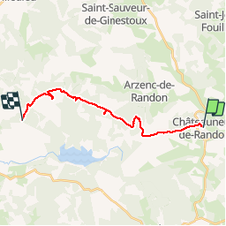
![](/images/other/stat-length.png)
![Tocht Stappen Châteauneuf-de-Randon - CHATEAUNEUF DE RANDON vers LE PIC DE FORTUNIO - Photo](https://media.geolcdn.com/t/1900/400/c12376eb-b4e0-491b-bdc5-bb7632689f13.jpg&format=pjpeg&maxdim=2)
CHATEAUNEUF DE RANDON vers LE PIC DE FORTUNIO
FLORENSAC
Gebruiker
![Lengte](/images/other/stat-length.png)
![Max. hoogte](https://static1.geolcdn.com/siteimages/upload/files/1508320355ic_sort_altitude_max_24dp.png)
![Positief hoogteverschil](https://static1.geolcdn.com/siteimages/upload/files/1508320355ic_sort_den_pos_24dp.png)
![Km-Effort](/images/other/stat-length.png)
![Min. hoogte](https://static1.geolcdn.com/siteimages/upload/files/1508320355ic_sort_altitude_min_24dp.png)
![Negatief hoogteverschil](https://static1.geolcdn.com/siteimages/upload/files/1508320355ic_sort_den_neg_24dp.png)
![Boucle](https://static1.geolcdn.com/siteimages/upload/files/16400158638029165_repeat_loop_refresh_sync_direction_icon.png)
![Stappen](https://static1.geolcdn.com/sitytour/trail-icons/101.png)
6h38
Moeilijkheid : Moeilijk
![Scan deze QR-code om de tocht te openen in de SityTrail-applicatie](https://capi.geolives.com/qq0zvz2zws4bq2lad0pu/sitytour/trails/2214515/qr.png?size=200)
Gratisgps-wandelapplicatie
Over ons
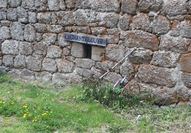
Tocht Stappen van 17,6 km beschikbaar op Occitanië, Lozère, Châteauneuf-de-Randon. Deze tocht wordt voorgesteld door FLORENSAC.
Beschrijving
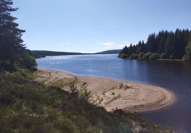
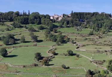
Très belle randonnée en suivant bien le tracé , plusieurs jolies choses à voir sur ce parcours linéaire
départ parking derrière l'église
après une jolie descente bien escarpée traverser la route et remonter en face en passant devant la FONTAINE DUGESCLIN
nous sommes passés à travers bois pour raccourcir le trajet
(donc c'est normal qu'il n'y ai pas de sentier )
reprendre la piste
en chemin aller voir la stèle d'un berger mort foudroyé avec ses 200 moutons (balisage bleu à travers le bois )
un peu plus loin (voir la pierre trouée en forme de croix )
reprendre le chemin dans un grand virage sur la piste balisage sur l’extrême gauche (bleu) une belle montée en suivant la lisière du bois sur un sentier ou on passe en file indienne
longer la clôture et descendre à un moment donné pour aller voir les ruines d'un ancien ermitage
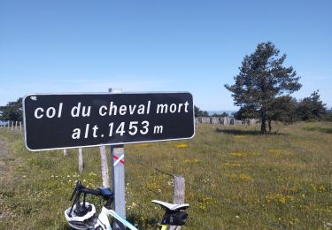
remonter au sentier et continuer jusqu'a l'ancienne base militaire et ses vestiges continer jusqu'au pic de Fortunio
Plaatsbepaling
Opmerkingen
Wandeltochten in de omgeving
![Tocht Wegfiets Arzenc-de-Randon - lac de Charpal - Photo](https://media.geolcdn.com/t/375/260/3f7c5fe6-3e82-45cc-b69f-ed6645d295d6.jpg&format=jpg&maxdim=2)
![Wegfiets Wegfiets](https://static1.geolcdn.com/sitytour/trail-icons/201.png)
Wegfiets
![](/images/other/stat-length.png)
![](https://static1.geolcdn.com/siteimages/upload/files/16400158638029165_repeat_loop_refresh_sync_direction_icon.png)
![Tocht Wegfiets Châteauneuf-de-Randon - col du cheval mort - Photo](https://media.geolcdn.com/t/375/260/7aff11be-1e32-4bec-9331-ac96b472b4cf.jpg&format=jpg&maxdim=2)
![Wegfiets Wegfiets](https://static1.geolcdn.com/sitytour/trail-icons/201.png)
Wegfiets
![](/images/other/stat-length.png)
![](https://static1.geolcdn.com/siteimages/upload/files/16400158638029165_repeat_loop_refresh_sync_direction_icon.png)
![Tocht Elektrische fiets Arzenc-de-Randon - AUBRAC 3dle étape - Photo](https://media.geolcdn.com/t/375/260/d376c1b4-9c6e-4202-afd1-aac42f285ca4.jpg&format=jpg&maxdim=2)
![Elektrische fiets Elektrische fiets](https://static1.geolcdn.com/sitytour/trail-icons/205.png)
Elektrische fiets
![](/images/other/stat-length.png)
![](https://static1.geolcdn.com/siteimages/upload/files/16400158638029165_repeat_loop_refresh_sync_direction_icon.png)
![Tocht Paardrijden Châteauneuf-de-Randon - 2022-09-18 Rando CVA Lozere Chateauneuf de Randon vers Chasserades - Photo](https://media.geolcdn.com/t/375/260/4de9d141-8b47-4780-80cf-3f0f751d0dba.jpg&format=jpg&maxdim=2)
![Paardrijden Paardrijden](https://static1.geolcdn.com/sitytour/trail-icons/301.png)
Paardrijden
![](/images/other/stat-length.png)
![](https://static1.geolcdn.com/siteimages/upload/files/16400158638029165_repeat_loop_refresh_sync_direction_icon.png)
![Tocht Stappen Arzenc-de-Randon - Arzenc de Rendon - Photo](https://media.geolcdn.com/t/375/260/884848ea-c75f-40b5-bbe1-9d52dd42c755.jpg&format=jpg&maxdim=2)
![Stappen Stappen](https://static1.geolcdn.com/sitytour/trail-icons/101.png)
Stappen
![](/images/other/stat-length.png)
![](https://static1.geolcdn.com/siteimages/upload/files/16400158638029165_repeat_loop_refresh_sync_direction_icon.png)
![Tocht Paardrijden Châteauneuf-de-Randon - Etoile Etoile du Château Hotel de la Poste - Photo](https://media.geolcdn.com/t/375/260/ext.jpg?maxdim=2&url=https%3A%2F%2Fstatic1.geolcdn.com%2Fsiteimages%2Fupload%2Ffiles%2F1524743154cheval.jpg)
![Paardrijden Paardrijden](https://static1.geolcdn.com/sitytour/trail-icons/301.png)
Paardrijden
![](/images/other/stat-length.png)
![](https://static1.geolcdn.com/siteimages/upload/files/16400158638029165_repeat_loop_refresh_sync_direction_icon.png)
![Tocht Elektrische fiets Châteauneuf-de-Randon - Tour du Fortunio - Photo](https://media.geolcdn.com/t/375/260/ext.jpg?maxdim=2&url=https%3A%2F%2Fstatic1.geolcdn.com%2Fsiteimages%2Fupload%2Ffiles%2F1524743154velo.jpg)
![Elektrische fiets Elektrische fiets](https://static1.geolcdn.com/sitytour/trail-icons/205.png)
Elektrische fiets
![](/images/other/stat-length.png)
![](https://static1.geolcdn.com/siteimages/upload/files/16400158638029165_repeat_loop_refresh_sync_direction_icon.png)
![Tocht Quad Arzenc-de-Randon - boucle chateauneuf de randon - Photo](https://media.geolcdn.com/t/375/260/ext.jpg?maxdim=2&url=https%3A%2F%2Fstatic1.geolcdn.com%2Fsiteimages%2Fupload%2Ffiles%2F15247431544x4.jpg)
![Quad Quad](https://static1.geolcdn.com/sitytour/trail-icons/404.png)
Quad
![](/images/other/stat-length.png)
![](https://static1.geolcdn.com/siteimages/upload/files/16400158638029165_repeat_loop_refresh_sync_direction_icon.png)
![Tocht sport Châteauneuf-de-Randon - Raccourci - Photo](https://media.geolcdn.com/t/375/260/ext.jpg?maxdim=2&url=https%3A%2F%2Fsecurestorage.geolives.com%2Fsitytour%2Ftrail-bg%2Fdefault.jpg)
sport
![](/images/other/stat-length.png)
![](https://static1.geolcdn.com/siteimages/upload/files/16400158638029165_repeat_loop_refresh_sync_direction_icon.png)