![](/images/other/stat-length.png)
![Tocht Stappen Liddes - Vichères - Combe de l''A - Photo](https://media.geolcdn.com/t/1900/400/ext.pjpeg?maxdim=2&url=https%3A%2F%2Fstatic1.geolcdn.com%2Fsiteimages%2Fupload%2Ffiles%2F1553511878bg_sport_marche.png)
Vichères - Combe de l''A
duamerg
Gebruiker
![Lengte](/images/other/stat-length.png)
Lengte
20 km
![Max. hoogte](https://static1.geolcdn.com/siteimages/upload/files/1508320355ic_sort_altitude_max_24dp.png)
Max. hoogte
2762 m
![Positief hoogteverschil](https://static1.geolcdn.com/siteimages/upload/files/1508320355ic_sort_den_pos_24dp.png)
Positief hoogteverschil
1240 m
![Km-Effort](/images/other/stat-length.png)
Km-Effort
37 km
![Min. hoogte](https://static1.geolcdn.com/siteimages/upload/files/1508320355ic_sort_altitude_min_24dp.png)
Min. hoogte
1577 m
![Negatief hoogteverschil](https://static1.geolcdn.com/siteimages/upload/files/1508320355ic_sort_den_neg_24dp.png)
Negatief hoogteverschil
1234 m
![Boucle](https://static1.geolcdn.com/siteimages/upload/files/16400158638029165_repeat_loop_refresh_sync_direction_icon.png)
Boucle
Ja
Datum van aanmaak :
2014-12-11 00:00:00.0
Laatste wijziging :
2020-01-30 13:58:34.354
![Stappen](https://static1.geolcdn.com/sitytour/trail-icons/101.png)
7h30
Moeilijkheid : Medium
![Scan deze QR-code om de tocht te openen in de SityTrail-applicatie](https://capi.geolives.com/qq0zvz2zws4bq2lad0pu/sitytour/trails/22039/qr.png?size=200)
Gratisgps-wandelapplicatie
Over ons
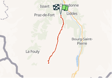
Tocht Stappen van 20 km beschikbaar op Valais/Wallis, Entremont, Liddes. Deze tocht wordt voorgesteld door duamerg.
Beschrijving
Longue course à faire en fin d'été pour éviter la neige. Au col du Névé de la Rousse se trouve une étendue de sable comme au bord de la mer !
Plaatsbepaling
Land:
Switzerland
Regio :
Valais/Wallis
Departement/Provincie :
Entremont
Gemeente :
Liddes
Locatie:
Unknown
Vertrek:(Dec)
Vertrek:(UTM)
357661 ; 5094523 (32T) N.
Opmerkingen
Wandeltochten in de omgeving
![Tocht Te voet Liddes - Chemins pédestre, commune de Liddes - Photo](https://media.geolcdn.com/t/375/260/3cf7ef9d-0d1e-4276-b8c3-9835d2b9d603.jpeg&format=jpg&maxdim=2)
![Te voet Te voet](https://static1.geolcdn.com/sitytour/trail-icons/100.png)
Chemins pédestre, commune de Liddes
Te voet
Gemakkelijk
Liddes,
Valais/Wallis,
Entremont,
Switzerland
![](/images/other/stat-length.png)
4,3 km | 6,4 km-effort
1h 27min
![](https://static1.geolcdn.com/siteimages/upload/files/16400158638029165_repeat_loop_refresh_sync_direction_icon.png)
Neen
![Tocht Te voet Orsières - sentier du Devin - Photo](https://media.geolcdn.com/t/375/260/1486fc85-352e-404e-b600-0f3d7bac1924.jpeg&format=jpg&maxdim=2)
![Te voet Te voet](https://static1.geolcdn.com/sitytour/trail-icons/100.png)
sentier du Devin
Te voet
Gemakkelijk
Orsières,
Valais/Wallis,
Entremont,
Switzerland
![](/images/other/stat-length.png)
3,9 km | 6,7 km-effort
1h 31min
![](https://static1.geolcdn.com/siteimages/upload/files/16400158638029165_repeat_loop_refresh_sync_direction_icon.png)
Ja
![Tocht Te voet Liddes - Chemins pédestre de montagne, région Orsières - Photo](https://media.geolcdn.com/t/375/260/8db834a7-d9d6-41f8-95ac-2756844d7a1f.jpeg&format=jpg&maxdim=2)
![Te voet Te voet](https://static1.geolcdn.com/sitytour/trail-icons/100.png)
Chemins pédestre de montagne, région Orsières
Te voet
Gemakkelijk
Liddes,
Valais/Wallis,
Entremont,
Switzerland
![](/images/other/stat-length.png)
6,7 km | 9,9 km-effort
2h 14min
![](https://static1.geolcdn.com/siteimages/upload/files/16400158638029165_repeat_loop_refresh_sync_direction_icon.png)
Neen
![Tocht Stappen Liddes - Combe de l’A - Photo](https://media.geolcdn.com/t/375/260/80b3ab05-1db2-4115-987f-2856a50ccafd.jpg&format=jpg&maxdim=2)
![Stappen Stappen](https://static1.geolcdn.com/sitytour/trail-icons/101.png)
Combe de l’A
Stappen
Medium
Liddes,
Valais/Wallis,
Entremont,
Switzerland
![](/images/other/stat-length.png)
6,8 km | 12 km-effort
3h 27min
![](https://static1.geolcdn.com/siteimages/upload/files/16400158638029165_repeat_loop_refresh_sync_direction_icon.png)
Neen
![Tocht Te voet Orsières - Raccard du blé - Photo](https://media.geolcdn.com/t/375/260/e3af305e-4edc-4919-bcad-22d8b69ac232.jpeg&format=jpg&maxdim=2)
![Te voet Te voet](https://static1.geolcdn.com/sitytour/trail-icons/100.png)
Raccard du blé
Te voet
Gemakkelijk
Orsières,
Valais/Wallis,
Entremont,
Switzerland
![](/images/other/stat-length.png)
7,9 km | 13,7 km-effort
3h 6min
![](https://static1.geolcdn.com/siteimages/upload/files/16400158638029165_repeat_loop_refresh_sync_direction_icon.png)
Ja
![Tocht Sneeuwschoenen Orsières - Champex Lac - La Breya - Champex Lac - Photo](https://media.geolcdn.com/t/375/260/6555df26-5e72-41d3-9ea4-2761199f667f.jpg&format=jpg&maxdim=2)
![Sneeuwschoenen Sneeuwschoenen](https://static1.geolcdn.com/sitytour/trail-icons/504.png)
Champex Lac - La Breya - Champex Lac
Sneeuwschoenen
Medium
Orsières,
Valais/Wallis,
Entremont,
Switzerland
![](/images/other/stat-length.png)
8,8 km | 18,2 km-effort
3h 1min
![](https://static1.geolcdn.com/siteimages/upload/files/16400158638029165_repeat_loop_refresh_sync_direction_icon.png)
Ja
![Tocht Stappen Liddes - CMX ZRMT ÉTAPE 3 de Cabane de Mille à Cabane de Louvie. - Photo](https://media.geolcdn.com/t/375/260/ext.jpg?maxdim=2&url=https%3A%2F%2Fservices.sitytrail.com%2FGeolivesWS%2FDownloadMedia.ashx%3FTrailID%3D635929%26Media%3Dfix__20160915162854.jpg)
![Stappen Stappen](https://static1.geolcdn.com/sitytour/trail-icons/101.png)
CMX ZRMT ÉTAPE 3 de Cabane de Mille à Cabane de Louvie.
Stappen
Gemakkelijk
Liddes,
Valais/Wallis,
Entremont,
Switzerland
![](/images/other/stat-length.png)
18,6 km | 35 km-effort
7h 13min
![](https://static1.geolcdn.com/siteimages/upload/files/16400158638029165_repeat_loop_refresh_sync_direction_icon.png)
Neen
![Tocht Stappen Orsières - CMX ZRMT Étape 2 Champex Cabane de Mille - Photo](https://media.geolcdn.com/t/375/260/ext.jpg?maxdim=2&url=https%3A%2F%2Fservices.sitytrail.com%2FGeolivesWS%2FDownloadMedia.ashx%3FTrailID%3D635928%26Media%3Dfix__20160914135625.jpg)
![Stappen Stappen](https://static1.geolcdn.com/sitytour/trail-icons/101.png)
CMX ZRMT Étape 2 Champex Cabane de Mille
Stappen
Medium
Orsières,
Valais/Wallis,
Entremont,
Switzerland
![](/images/other/stat-length.png)
17,9 km | 38 km-effort
7h 15min
![](https://static1.geolcdn.com/siteimages/upload/files/16400158638029165_repeat_loop_refresh_sync_direction_icon.png)
Neen
![Tocht Sneeuwschoenen Orsières - Champex Lac - Belvédère - Champex Lac - Photo](https://media.geolcdn.com/t/375/260/151cbdcc-6b32-4a22-81f7-c78a0d516444.jpg&format=jpg&maxdim=2)
![Sneeuwschoenen Sneeuwschoenen](https://static1.geolcdn.com/sitytour/trail-icons/504.png)
Champex Lac - Belvédère - Champex Lac
Sneeuwschoenen
Medium
Orsières,
Valais/Wallis,
Entremont,
Switzerland
![](/images/other/stat-length.png)
8,4 km | 13,6 km-effort
2h 52min
![](https://static1.geolcdn.com/siteimages/upload/files/16400158638029165_repeat_loop_refresh_sync_direction_icon.png)
Ja