Tocht Noords wandelen Bénac - la pierre du diable - Photo
 Loucha
Loucha

Gebruiker

© OpenStreetMap contributors
Lengte
Lengte
8,3 km
Max. hoogte
Max. hoogte
491 m
Positief hoogteverschil
250 m
Km-Effort
Km-Effort  
11,6 km
Min. hoogte
Min. hoogte
350 m
Negatief hoogteverschil
248 m
Boucle
Boucle
Neen
Datum van aanmaak :
2019-09-07 14:29:56.803
Laatste wijziging :
2019-09-07 18:08:34.407

(1 Bericht)

Noords wandelen
Noords wandelen
1h40
Moeilijkheid : Heel gemakkelijk

Scan deze QR-code om de tocht te openen in de SityTrail-applicatie

Gratisgps-wandelapplicatie

Logo SityTrail SityTrail

IGN / Geografische instituten

SityTrail uit de App Store downloaden SityTrail uit Google Play downloaden

Logo SityTrail SityTrail World

De wereld gaat voor u open

SityTrail uit de App Store downloaden SityTrail uit Google Play downloaden SityTrail op Huawei AppGallery downloaden

Over ons

Tocht Noords wandelen van 8,3 km beschikbaar op Occitanië, Hautes-Pyrénées, Bénac. Deze tocht wordt voorgesteld door Loucha.

Beschrijving

MN au départ de Benac

Hoogteprofiel

Plaatsbepaling

Land:
France
Regio :
Occitanië
Departement/Provincie :
Hautes-Pyrénées
Gemeente :
Bénac
Locatie:
Unknown
Vertrek:(UTM)
258174 ; 4782101 (31T) N.

Opmerkingen

Gelieve in te loggen om een commentaar of een beoordeling achter te laten


Wandeltochten in de omgeving

Tocht Te voet Lanne - Le Chemin des Crêtes - Photo
Te voet
GUIDE+

Te voet

Gemakkelijk
Lanne, Occitanië, Hautes-Pyrénées, France
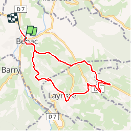
11,4 km | 14,4 km-effort
3h 16min
Ja
Tocht Andere activiteiten Lanne - Averan les crêtes court - Photo
Andere activiteiten
GIRAUDEL

Andere activiteiten

Gemakkelijk
(1)
Lanne, Occitanië, Hautes-Pyrénées, France
10 km | 12,6 km-effort
2h 20min
Ja
Tocht Noords wandelen Horgues - Horgues Odos - Photo
Noords wandelen
GIRAUDEL

Noords wandelen

Gemakkelijk
Horgues, Occitanië, Hautes-Pyrénées, France
9,1 km | 9,8 km-effort
2h 3min
Ja
Tocht Noords wandelen Juillan - juillan hibarette louey  - Photo
Noords wandelen
Loucha

Noords wandelen

Heel gemakkelijk
Juillan, Occitanië, Hautes-Pyrénées, France
7,7 km | 9,6 km-effort
1h 38min
Ja
Tocht Stappen Orincles - Les chemins de Loucrup - Photo
Stappen
GIRAUDEL

Stappen

Gemakkelijk
Orincles, Occitanië, Hautes-Pyrénées, France
9,4 km | 12,5 km-effort
2h 49min
Ja
Tocht Te voet Barry - -Barry - Miramont - Photo
Te voet
mitch1952

Te voet

Gemakkelijk
Barry, Occitanië, Hautes-Pyrénées, France
9,9 km | 14,1 km-effort
3h 12min
Ja
Tocht Te voet Adé - G3 Ail des Ours et Miramont - Photo
Te voet
mitch1952

Te voet

Gemakkelijk
Adé, Occitanië, Hautes-Pyrénées, France
11,7 km | 16,7 km-effort
3h 48min
Ja
Tocht Te voet Lanne - 2021-05-02 16:57:34 - Photo
Te voet
mitch1952

Te voet

Medium
Lanne, Occitanië, Hautes-Pyrénées, France
18,6 km | 25 km-effort
5h 42min
Ja
Tocht Te voet Lanne - 2021-04-16 16:42:06 - Photo
Te voet
mitch1952

Te voet

Medium
Lanne, Occitanië, Hautes-Pyrénées, France
21 km | 30 km-effort
6h 48min
Ja


Sluiten
Mijn abonnementen