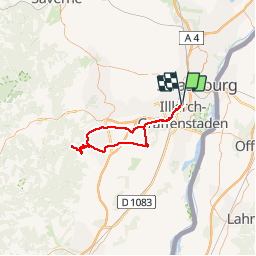
![](/images/other/stat-length.png)
![Tocht Wegfiets Ostwald - Sortie piste et route - Photo](https://media.geolcdn.com/t/1900/400/9fb28e6a-dc46-49cf-9443-8a3b97e7f318.jpg&format=pjpeg&maxdim=2)
Sortie piste et route
26051010
Gebruiker
![Lengte](/images/other/stat-length.png)
![Max. hoogte](https://static1.geolcdn.com/siteimages/upload/files/1508320355ic_sort_altitude_max_24dp.png)
![Positief hoogteverschil](https://static1.geolcdn.com/siteimages/upload/files/1508320355ic_sort_den_pos_24dp.png)
![Km-Effort](/images/other/stat-length.png)
![Min. hoogte](https://static1.geolcdn.com/siteimages/upload/files/1508320355ic_sort_altitude_min_24dp.png)
![Negatief hoogteverschil](https://static1.geolcdn.com/siteimages/upload/files/1508320355ic_sort_den_neg_24dp.png)
![Boucle](https://static1.geolcdn.com/siteimages/upload/files/16400158638029165_repeat_loop_refresh_sync_direction_icon.png)
![Wegfiets](https://static1.geolcdn.com/sitytour/trail-icons/201.png)
4h15
Moeilijkheid : Medium
![Scan deze QR-code om de tocht te openen in de SityTrail-applicatie](https://capi.geolives.com/qq0zvz2zws4bq2lad0pu/sitytour/trails/2190050/qr.png?size=200)
Gratisgps-wandelapplicatie
Over ons
Tocht Wegfiets van 72 km beschikbaar op Grand Est, Bas-Rhin, Ostwald. Deze tocht wordt voorgesteld door 26051010.
Beschrijving
Sortie piste et route
Départ Ostwald direction Geispolsheim Gare
Geispolsheim -Blaesheim à Blaesheim prendre
Direction Hindisheim une petite route bien
Tranquille jusqu’à l’intersection direction
Krautergersheim à la fin du village prendre
à gauche direction Obernai -St-Leonard-
Ottrott -Klingenthal petite visite de la
manufacture - d’armes blanches
Puis redirection Ottrott vers St-Nabor
pour prendre la piste chemin des carrières
Portes Bonheur jusqu’à Rosheim
Griesheim-près-Molsheim -Innenheim- piste
sur Blaesheim Geispolsheim et ostwald
Plaatsbepaling
Opmerkingen
Wandeltochten in de omgeving
![Tocht Stappen Straatsburg - Strasbourg - Centre historique - Photo](https://media.geolcdn.com/t/375/260/ext.jpg?maxdim=2&url=https%3A%2F%2Fservices.sitytrail.com%2FGeolivesWS%2FDownloadMedia.ashx%3FTrailID%3D714530%26Media%3Dfix__20170315162311.jpg)
![Stappen Stappen](https://static1.geolcdn.com/sitytour/trail-icons/101.png)
Stappen
![](/images/other/stat-length.png)
![](https://static1.geolcdn.com/siteimages/upload/files/16400158638029165_repeat_loop_refresh_sync_direction_icon.png)
![Tocht Stappen Straatsburg - Untitled - Photo](https://media.geolcdn.com/t/375/260/ext.jpg?maxdim=2&url=https%3A%2F%2Fservices.sitytrail.com%2FGeolivesWS%2FDownloadMedia.ashx%3FTrailID%3D378325%26Media%3D20150118104613.jpg)
![Stappen Stappen](https://static1.geolcdn.com/sitytour/trail-icons/101.png)
Stappen
![](/images/other/stat-length.png)
![](https://static1.geolcdn.com/siteimages/upload/files/16400158638029165_repeat_loop_refresh_sync_direction_icon.png)
![Tocht Stappen Straatsburg - Strasbourg Krutenau Université - Photo](https://media.geolcdn.com/t/375/260/8cbb56df-c20b-4a21-8b38-d84143e8ba5e.jpg&format=jpg&maxdim=2)
![Stappen Stappen](https://static1.geolcdn.com/sitytour/trail-icons/101.png)
Stappen
![](/images/other/stat-length.png)
![](https://static1.geolcdn.com/siteimages/upload/files/16400158638029165_repeat_loop_refresh_sync_direction_icon.png)
![Tocht sport Wolfisheim - 20241213 Wolfisheim - Photo](https://media.geolcdn.com/t/375/260/b82d77db-7d71-4ee9-aaab-c2a4d356d4d1.jpg&format=jpg&maxdim=2)
sport
![](/images/other/stat-length.png)
![](https://static1.geolcdn.com/siteimages/upload/files/16400158638029165_repeat_loop_refresh_sync_direction_icon.png)
![Tocht Stappen Ostwald - Tayla - Photo](https://media.geolcdn.com/t/375/260/236e4d72-747b-45d2-ae4f-84e3c8bc8c57.jpg&format=jpg&maxdim=2)
![Stappen Stappen](https://static1.geolcdn.com/sitytour/trail-icons/101.png)
![Tocht Stappen Ostwald - Lundi - Photo](https://media.geolcdn.com/t/375/260/7f259d80-50fa-422a-96ef-cd2ae8fbda1c.jpg&format=jpg&maxdim=2)
![Stappen Stappen](https://static1.geolcdn.com/sitytour/trail-icons/101.png)
Stappen
![](/images/other/stat-length.png)
![](https://static1.geolcdn.com/siteimages/upload/files/16400158638029165_repeat_loop_refresh_sync_direction_icon.png)
![Tocht Elektrische fiets Ostwald - Promenade Vosges - Photo](https://media.geolcdn.com/t/375/260/f9c256ef-dfcd-431d-8977-ca099c8aa398.jpg&format=jpg&maxdim=2)
![Elektrische fiets Elektrische fiets](https://static1.geolcdn.com/sitytour/trail-icons/205.png)
Elektrische fiets
![](/images/other/stat-length.png)
![](https://static1.geolcdn.com/siteimages/upload/files/16400158638029165_repeat_loop_refresh_sync_direction_icon.png)
![Tocht Elektrische fiets Ostwald - Nideck carrefour des Pandours - Photo](https://media.geolcdn.com/t/375/260/e2ea2c89-1b62-4f65-a986-fc596c752bcf.jpg&format=jpg&maxdim=2)
![Elektrische fiets Elektrische fiets](https://static1.geolcdn.com/sitytour/trail-icons/205.png)
Elektrische fiets
![](/images/other/stat-length.png)
![](https://static1.geolcdn.com/siteimages/upload/files/16400158638029165_repeat_loop_refresh_sync_direction_icon.png)
![Tocht Mountainbike Ostwald - Ostwald Etang du loup - Photo](https://media.geolcdn.com/t/375/260/b25b355f-15e8-48e3-8757-005d4424f736.jpg&format=jpg&maxdim=2)
![Mountainbike Mountainbike](https://static1.geolcdn.com/sitytour/trail-icons/202.png)
Mountainbike
![](/images/other/stat-length.png)
![](https://static1.geolcdn.com/siteimages/upload/files/16400158638029165_repeat_loop_refresh_sync_direction_icon.png)