Tocht Mountainbike Lachapelle-aux-Pots - ACTIVE LOG 003 - Photo
 sebcar
sebcar

Gebruiker

© OpenStreetMap contributors
Lengte
Lengte
19,1 km
Max. hoogte
Max. hoogte
237 m
Positief hoogteverschil
374 m
Km-Effort
Km-Effort  
24 km
Min. hoogte
Min. hoogte
84 m
Negatief hoogteverschil
374 m
Boucle
Boucle
Ja
Datum van aanmaak :
2019-08-23 18:13:09.798
Laatste wijziging :
2019-08-24 12:49:18.958

(1 Bericht)

Mountainbike
Mountainbike
1h39
Moeilijkheid : Medium

Scan deze QR-code om de tocht te openen in de SityTrail-applicatie

Gratisgps-wandelapplicatie

Logo SityTrail SityTrail

IGN / Geografische instituten

SityTrail uit de App Store downloaden SityTrail uit Google Play downloaden

Logo SityTrail SityTrail World

De wereld gaat voor u open

SityTrail uit de App Store downloaden SityTrail uit Google Play downloaden SityTrail op Huawei AppGallery downloaden

Over ons

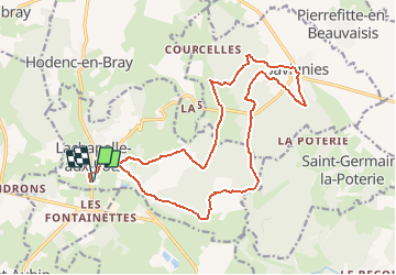
Tocht Mountainbike van 19,1 km beschikbaar op Hauts-de-France, Oise, Lachapelle-aux-Pots. Deze tocht wordt voorgesteld door sebcar.

Beschrijving

Belle façon de découvrir les caractéristiques paysagères et géologiques du flanc est du pays de Bray.
Attention à Lhuyère le chemin à disparu suite à un "remembrement personnalisé" du cultivateur.

Hoogteprofiel

Plaatsbepaling

Land:
France
Regio :
Hauts-de-France
Departement/Provincie :
Oise
Gemeente :
Lachapelle-aux-Pots
Locatie:
Unknown
Vertrek:(Dec)
Vertrek:(UTM)
420392 ; 5477224 (31U) N.

Opmerkingen

Gelieve in te loggen om een commentaar of een beoordeling achter te laten


Wandeltochten in de omgeving

Tocht Mountainbike Pierrefitte-en-Beauvaisis - Grand tour - Photo
Mountainbike
jjeletufe

Mountainbike

(1)
Pierrefitte-en-Beauvaisis, Hauts-de-France, Oise, France
30 km | 35 km-effort
1h 44min
Ja
Tocht Stappen Senantes - Senantes - Photo
Stappen
jpblimond

Stappen

Medium
Senantes, Hauts-de-France, Oise, France
18,7 km | 23 km-effort
4h 47min
Ja
Tocht Stappen Savignies - savignies - Photo
Stappen
Novomarquiens

Stappen

Gemakkelijk
Savignies, Hauts-de-France, Oise, France
9,3 km | 12 km-effort
3h 0min
Ja
Tocht Stappen Lalandelle - Lalandelle - La boutonnière du pays de Bray - Photo
Stappen
Marie-Claire-mcp

Stappen

Moeilijk
Lalandelle, Hauts-de-France, Oise, France
10,4 km | 12,5 km-effort
2h 50min
Ja
Tocht Stappen Lalandelle - Forêt domaniale de Thelle à partir de Lalandelle - Photo
Stappen
Marie-Claire-mcp

Stappen

Moeilijk
Lalandelle, Hauts-de-France, Oise, France
11 km | 13,1 km-effort
2h 59min
Ja
Tocht Stappen Lachapelle-aux-Pots - Lachapelle-aux-pots - Héricourt - La Frénoye - Armentières - Photo
Stappen
Marie-Claire-mcp

Stappen

Moeilijk
Lachapelle-aux-Pots, Hauts-de-France, Oise, France
10,7 km | 13,7 km-effort
3h 6min
Ja
Tocht Stappen Lachapelle-aux-Pots - Lachapelle aux pots - Armentières 11 km - Photo
Stappen
Marie-Claire-mcp

Stappen

Moeilijk
Lachapelle-aux-Pots, Hauts-de-France, Oise, France
10,6 km | 13,5 km-effort
3h 4min
Ja
Tocht Stappen Lachapelle-aux-Pots - Lachapelle aux Pots - Rando santé 1 - Photo
Stappen
marcel.F

Stappen

Medium
Lachapelle-aux-Pots, Hauts-de-France, Oise, France
5,6 km | 6,4 km-effort
1h 24min
Ja
Tocht Stappen Lachapelle-aux-Pots - Lachapelle-aux-Pots - autour de la Crapaudière vers 2 - Photo
Stappen
marcel.F

Stappen

Gemakkelijk
Lachapelle-aux-Pots, Hauts-de-France, Oise, France
9,9 km | 11,5 km-effort
2h 32min
Ja


Sluiten
Mijn abonnementen