![](/images/other/stat-length.png)
![Tocht Mountainbike Yvoir - GODINNE ... par le hameau de Hun et les 7 Meuses - Photo](https://media.geolcdn.com/t/1900/400/ext.pjpeg?maxdim=2&url=https%3A%2F%2Fstatic1.geolcdn.com%2Fsiteimages%2Fupload%2Ffiles%2F1524743154velo.jpg)
GODINNE ... par le hameau de Hun et les 7 Meuses
GerardBouche
Gebruiker
![Lengte](/images/other/stat-length.png)
Lengte
20 km
![Max. hoogte](https://static1.geolcdn.com/siteimages/upload/files/1508320355ic_sort_altitude_max_24dp.png)
Max. hoogte
272 m
![Positief hoogteverschil](https://static1.geolcdn.com/siteimages/upload/files/1508320355ic_sort_den_pos_24dp.png)
Positief hoogteverschil
468 m
![Km-Effort](/images/other/stat-length.png)
Km-Effort
27 km
![Min. hoogte](https://static1.geolcdn.com/siteimages/upload/files/1508320355ic_sort_altitude_min_24dp.png)
Min. hoogte
72 m
![Negatief hoogteverschil](https://static1.geolcdn.com/siteimages/upload/files/1508320355ic_sort_den_neg_24dp.png)
Negatief hoogteverschil
469 m
![Boucle](https://static1.geolcdn.com/siteimages/upload/files/16400158638029165_repeat_loop_refresh_sync_direction_icon.png)
Boucle
Ja
Datum van aanmaak :
2019-08-23 12:43:59.009
Laatste wijziging :
2019-08-23 15:14:59.858
![Mountainbike](https://static1.geolcdn.com/sitytour/trail-icons/202.png)
1h43
Moeilijkheid : Gemakkelijk
![Scan deze QR-code om de tocht te openen in de SityTrail-applicatie](https://capi.geolives.com/qq0zvz2zws4bq2lad0pu/sitytour/trails/2180448/qr.png?size=200)
Gratisgps-wandelapplicatie
Over ons
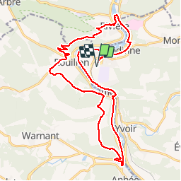
Tocht Mountainbike van 20 km beschikbaar op Wallonië, Namen, Yvoir. Deze tocht wordt voorgesteld door GerardBouche.
Beschrijving
Par la rive gauche de Meuse, le hameau de Hun et montée vers les Jardins d'Annevoie avant de rejoindre le point de vue des 7 Meuses. Descente par le petit sentier (qlq escaliers) qui aboutit à l'église de Rivière et la rive gauche de la Meuse.
Plaatsbepaling
Land:
Belgium
Regio :
Wallonië
Departement/Provincie :
Namen
Gemeente :
Yvoir
Locatie:
Godinne
Vertrek:(Dec)
Vertrek:(UTM)
632612 ; 5578682 (31U) N.
Opmerkingen
Wandeltochten in de omgeving
![Tocht Stappen Profondeville - GG-Na-19_ Lustin - Namur - Photo](https://media.geolcdn.com/t/375/260/b0b5ef2e-bf0c-4965-a3a2-62d0da2d07c7.jpg&format=jpg&maxdim=2)
![Stappen Stappen](https://static1.geolcdn.com/sitytour/trail-icons/101.png)
GG-Na-19_ Lustin - Namur
Stappen
Zeer moeilijk
(13)
Profondeville,
Wallonië,
Namen,
Belgium
![](/images/other/stat-length.png)
22 km | 28 km-effort
6h 7min
![](https://static1.geolcdn.com/siteimages/upload/files/16400158638029165_repeat_loop_refresh_sync_direction_icon.png)
Neen
![Tocht Stappen Anhée - RB-Na-22-raccourci_Vignobles-et-Jardins-d’eau - Photo](https://media.geolcdn.com/t/375/260/9e39c4d6-ac1b-4acf-9686-7baae428f1a0.jpg&format=jpg&maxdim=2)
![Stappen Stappen](https://static1.geolcdn.com/sitytour/trail-icons/101.png)
RB-Na-22-raccourci_Vignobles-et-Jardins-d’eau
Stappen
Zeer moeilijk
(6)
Anhée,
Wallonië,
Namen,
Belgium
![](/images/other/stat-length.png)
16,7 km | 21 km-effort
4h 52min
![](https://static1.geolcdn.com/siteimages/upload/files/16400158638029165_repeat_loop_refresh_sync_direction_icon.png)
Ja
![Tocht Stappen Anhée - RB-Na-22_Vignobles-et-Jardins-d’eau - Photo](https://media.geolcdn.com/t/375/260/8622883f-03f3-4eff-8458-0cb9f1aba19e.jpg&format=jpg&maxdim=2)
![Stappen Stappen](https://static1.geolcdn.com/sitytour/trail-icons/101.png)
RB-Na-22_Vignobles-et-Jardins-d’eau
Stappen
Zeer moeilijk
(11)
Anhée,
Wallonië,
Namen,
Belgium
![](/images/other/stat-length.png)
19,5 km | 25 km-effort
5h 46min
![](https://static1.geolcdn.com/siteimages/upload/files/16400158638029165_repeat_loop_refresh_sync_direction_icon.png)
Ja
![Stappen Stappen](https://static1.geolcdn.com/sitytour/trail-icons/101.png)
RB-Na-21-Terres seigneuriales et carrières de la vallée du Bocq
Stappen
Zeer moeilijk
(6)
Yvoir,
Wallonië,
Namen,
Belgium
![](/images/other/stat-length.png)
22 km | 30 km-effort
6h 51min
![](https://static1.geolcdn.com/siteimages/upload/files/16400158638029165_repeat_loop_refresh_sync_direction_icon.png)
Ja
![Stappen Stappen](https://static1.geolcdn.com/sitytour/trail-icons/101.png)
RB-Na-20-Raccourci-2_Paysages_entre_Meuse_et_Burnot
Stappen
Zeer moeilijk
(11)
Profondeville,
Wallonië,
Namen,
Belgium
![](/images/other/stat-length.png)
14,6 km | 22 km-effort
4h 53min
![](https://static1.geolcdn.com/siteimages/upload/files/16400158638029165_repeat_loop_refresh_sync_direction_icon.png)
Ja
![Stappen Stappen](https://static1.geolcdn.com/sitytour/trail-icons/101.png)
RB-Na-20-Paysages_entre_Meuse_et_Burnot
Stappen
Zeer moeilijk
(16)
Profondeville,
Wallonië,
Namen,
Belgium
![](/images/other/stat-length.png)
18,5 km | 26 km-effort
5h 55min
![](https://static1.geolcdn.com/siteimages/upload/files/16400158638029165_repeat_loop_refresh_sync_direction_icon.png)
Ja
![Tocht Stappen Yvoir - RB-Na-03 Forteresses, citadelle et abbaye mosanes - Photo](https://media.geolcdn.com/t/375/260/ext.jpg?maxdim=2&url=https%3A%2F%2Fservices.sitytrail.com%2FGeolivesWS%2FDownloadMedia.ashx%3FTrailID%3D179628%26Media%3D8266bb1a-850d-41b8-8bad-8e0bd7c82bf9.jpg)
![Stappen Stappen](https://static1.geolcdn.com/sitytour/trail-icons/101.png)
RB-Na-03 Forteresses, citadelle et abbaye mosanes
Stappen
Moeilijk
(11)
Yvoir,
Wallonië,
Namen,
Belgium
![](/images/other/stat-length.png)
22 km | 30 km-effort
7h 1min
![](https://static1.geolcdn.com/siteimages/upload/files/16400158638029165_repeat_loop_refresh_sync_direction_icon.png)
Ja
![Tocht Stappen Yvoir - GG2-Na-38_Godinne-Dinant (2021-11-04) - Photo](https://media.geolcdn.com/t/375/260/4b7f8162-b405-4557-afe1-7567462c4aff.jpg&format=jpg&maxdim=2)
![Stappen Stappen](https://static1.geolcdn.com/sitytour/trail-icons/101.png)
GG2-Na-38_Godinne-Dinant (2021-11-04)
Stappen
Zeer moeilijk
(6)
Yvoir,
Wallonië,
Namen,
Belgium
![](/images/other/stat-length.png)
19,5 km | 27 km-effort
6h 13min
![](https://static1.geolcdn.com/siteimages/upload/files/16400158638029165_repeat_loop_refresh_sync_direction_icon.png)
Neen
![Tocht Stappen Anhée - RF-Na-05 Annevoie, côté Jardins_Grande-boucle - Photo](https://media.geolcdn.com/t/375/260/ext.jpg?maxdim=2&url=https%3A%2F%2Fservices.sitytrail.com%2FGeolivesWS%2FDownloadMedia.ashx%3FTrailID%3D545753%26Media%3D5d973c83-4a6c-40fc-a026-25de6c754887.JPG)
![Stappen Stappen](https://static1.geolcdn.com/sitytour/trail-icons/101.png)
RF-Na-05 Annevoie, côté Jardins_Grande-boucle
Stappen
Medium
(11)
Anhée,
Wallonië,
Namen,
Belgium
![](/images/other/stat-length.png)
11,3 km | 14,5 km-effort
3h 6min
![](https://static1.geolcdn.com/siteimages/upload/files/16400158638029165_repeat_loop_refresh_sync_direction_icon.png)
Ja