![](/images/other/stat-length.png)
![Tocht Hybride fiets La Ferté-Saint-Aubin - De la Ferté St aubin à Mézières lez Cléry - Photo](https://media.geolcdn.com/t/1900/400/ext.pjpeg?maxdim=2&url=https%3A%2F%2Fstatic1.geolcdn.com%2Fsiteimages%2Fupload%2Ffiles%2F1524743154velo.jpg)
De la Ferté St aubin à Mézières lez Cléry
Dp35
Gebruiker
![Lengte](/images/other/stat-length.png)
Lengte
19,1 km
![Max. hoogte](https://static1.geolcdn.com/siteimages/upload/files/1508320355ic_sort_altitude_max_24dp.png)
Max. hoogte
127 m
![Positief hoogteverschil](https://static1.geolcdn.com/siteimages/upload/files/1508320355ic_sort_den_pos_24dp.png)
Positief hoogteverschil
139 m
![Km-Effort](/images/other/stat-length.png)
Km-Effort
21 km
![Min. hoogte](https://static1.geolcdn.com/siteimages/upload/files/1508320355ic_sort_altitude_min_24dp.png)
Min. hoogte
93 m
![Negatief hoogteverschil](https://static1.geolcdn.com/siteimages/upload/files/1508320355ic_sort_den_neg_24dp.png)
Negatief hoogteverschil
146 m
![Boucle](https://static1.geolcdn.com/siteimages/upload/files/16400158638029165_repeat_loop_refresh_sync_direction_icon.png)
Boucle
Neen
Datum van aanmaak :
2019-08-21 14:52:11.736
Laatste wijziging :
2019-08-23 18:18:54.598
![Hybride fiets](https://static1.geolcdn.com/sitytour/trail-icons/203.png)
2h03
Moeilijkheid : Gemakkelijk
![Scan deze QR-code om de tocht te openen in de SityTrail-applicatie](https://capi.geolives.com/qq0zvz2zws4bq2lad0pu/sitytour/trails/2178547/qr.png?size=200)
Gratisgps-wandelapplicatie
Over ons
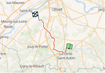
Tocht Hybride fiets van 19,1 km beschikbaar op Centre-Val de Loire, Loiret, La Ferté-Saint-Aubin. Deze tocht wordt voorgesteld door Dp35.
Beschrijving
Succession de difficultés liées aux propriétés privées fermées aux randonneurs et vélos.
De ce fait, 4km de routes au départ, autant à l'arrivée. Très moyen.
Il y a la possibilité de contourner ces difficultés, mais il faut chercher
Plaatsbepaling
Land:
France
Regio :
Centre-Val de Loire
Departement/Provincie :
Loiret
Gemeente :
La Ferté-Saint-Aubin
Locatie:
Unknown
Vertrek:(Dec)
Vertrek:(UTM)
420545 ; 5286382 (31T) N.
Opmerkingen
Wandeltochten in de omgeving
![Tocht Mountainbike La Ferté-Saint-Aubin - La Ferté St Anbin - Vouzon - Photo](https://media.geolcdn.com/t/375/260/ext.jpg?maxdim=2&url=https%3A%2F%2Fservices.sitytrail.com%2FGeolivesWS%2FDownloadMedia.ashx%3FTrailID%3D103899%26Media%3D6725_3.jpg)
![Mountainbike Mountainbike](https://static1.geolcdn.com/sitytour/trail-icons/202.png)
La Ferté St Anbin - Vouzon
Mountainbike
Medium
La Ferté-Saint-Aubin,
Centre-Val de Loire,
Loiret,
France
![](/images/other/stat-length.png)
37 km | 40 km-effort
3h 0min
![](https://static1.geolcdn.com/siteimages/upload/files/16400158638029165_repeat_loop_refresh_sync_direction_icon.png)
Ja
![Tocht Mountainbike La Ferté-Saint-Aubin - La ferté - Yvoy le marron - Photo](https://media.geolcdn.com/t/375/260/ext.jpg?maxdim=2&url=https%3A%2F%2Fservices.sitytrail.com%2FGeolivesWS%2FDownloadMedia.ashx%3FTrailID%3D722694%26Media%3D20170329165819.jpg)
![Mountainbike Mountainbike](https://static1.geolcdn.com/sitytour/trail-icons/202.png)
La ferté - Yvoy le marron
Mountainbike
Gemakkelijk
La Ferté-Saint-Aubin,
Centre-Val de Loire,
Loiret,
France
![](/images/other/stat-length.png)
23 km | 26 km-effort
2h 23min
![](https://static1.geolcdn.com/siteimages/upload/files/16400158638029165_repeat_loop_refresh_sync_direction_icon.png)
Ja
![Tocht Stappen La Ferté-Saint-Aubin - LA FERTE ST AUBIN - Photo](https://media.geolcdn.com/t/375/260/ext.jpg?maxdim=2&url=https%3A%2F%2Fstatic1.geolcdn.com%2Fsiteimages%2Fupload%2Ffiles%2F1553511878bg_sport_marche.png)
![Stappen Stappen](https://static1.geolcdn.com/sitytour/trail-icons/101.png)
LA FERTE ST AUBIN
Stappen
Heel gemakkelijk
La Ferté-Saint-Aubin,
Centre-Val de Loire,
Loiret,
France
![](/images/other/stat-length.png)
7,5 km | 8,3 km-effort
1h 50min
![](https://static1.geolcdn.com/siteimages/upload/files/16400158638029165_repeat_loop_refresh_sync_direction_icon.png)
Ja
![Tocht Mountainbike La Ferté-Saint-Aubin - VTT 36km La Ferté Chaumont Yvoy - Photo](https://media.geolcdn.com/t/375/260/ext.jpg?maxdim=2&url=https%3A%2F%2Fstatic1.geolcdn.com%2Fsiteimages%2Fupload%2Ffiles%2F1524743154velo.jpg)
![Mountainbike Mountainbike](https://static1.geolcdn.com/sitytour/trail-icons/202.png)
VTT 36km La Ferté Chaumont Yvoy
Mountainbike
Heel gemakkelijk
La Ferté-Saint-Aubin,
Centre-Val de Loire,
Loiret,
France
![](/images/other/stat-length.png)
36 km | 40 km-effort
2h 49min
![](https://static1.geolcdn.com/siteimages/upload/files/16400158638029165_repeat_loop_refresh_sync_direction_icon.png)
Ja
![Tocht Stappen La Ferté-Saint-Aubin - La Ferté-Saint -Aubin PR du Mazuray - Photo](https://media.geolcdn.com/t/375/260/ext.jpg?maxdim=2&url=https%3A%2F%2Fstatic1.geolcdn.com%2Fsiteimages%2Fupload%2Ffiles%2F1553511878bg_sport_marche.png)
![Stappen Stappen](https://static1.geolcdn.com/sitytour/trail-icons/101.png)
La Ferté-Saint -Aubin PR du Mazuray
Stappen
Gemakkelijk
La Ferté-Saint-Aubin,
Centre-Val de Loire,
Loiret,
France
![](/images/other/stat-length.png)
12,5 km | 13,9 km-effort
3h 3min
![](https://static1.geolcdn.com/siteimages/upload/files/16400158638029165_repeat_loop_refresh_sync_direction_icon.png)
Ja
![Tocht Mountainbike La Ferté-Saint-Aubin - 2010-09-19 LFSA - Lamothe Beuvron - Photo](https://media.geolcdn.com/t/375/260/ext.jpg?maxdim=2&url=https%3A%2F%2Fstatic1.geolcdn.com%2Fsiteimages%2Fupload%2Ffiles%2F1524743154velo.jpg)
![Mountainbike Mountainbike](https://static1.geolcdn.com/sitytour/trail-icons/202.png)
2010-09-19 LFSA - Lamothe Beuvron
Mountainbike
Heel gemakkelijk
La Ferté-Saint-Aubin,
Centre-Val de Loire,
Loiret,
France
![](/images/other/stat-length.png)
51 km | 57 km-effort
Onbekend
![](https://static1.geolcdn.com/siteimages/upload/files/16400158638029165_repeat_loop_refresh_sync_direction_icon.png)
Ja
![Tocht Te voet La Ferté-Saint-Aubin - Garmin essais 1 du 20 - Photo](https://media.geolcdn.com/t/375/260/ext.jpg?maxdim=2&url=https%3A%2F%2Fstatic1.geolcdn.com%2Fsiteimages%2Fupload%2Ffiles%2F1545311037marcheuse_200dpi.jpg)
![Te voet Te voet](https://static1.geolcdn.com/sitytour/trail-icons/100.png)
Garmin essais 1 du 20
Te voet
Gemakkelijk
La Ferté-Saint-Aubin,
Centre-Val de Loire,
Loiret,
France
![](/images/other/stat-length.png)
6,2 km | 6,9 km-effort
1h 34min
![](https://static1.geolcdn.com/siteimages/upload/files/16400158638029165_repeat_loop_refresh_sync_direction_icon.png)
Ja
![Tocht Stappen La Ferté-Saint-Aubin - venelles 2 - Photo](https://media.geolcdn.com/t/375/260/ext.jpg?maxdim=2&url=https%3A%2F%2Fstatic1.geolcdn.com%2Fsiteimages%2Fupload%2Ffiles%2F1553511878bg_sport_marche.png)
![Stappen Stappen](https://static1.geolcdn.com/sitytour/trail-icons/101.png)
venelles 2
Stappen
Heel gemakkelijk
La Ferté-Saint-Aubin,
Centre-Val de Loire,
Loiret,
France
![](/images/other/stat-length.png)
5,3 km | 6 km-effort
1h 12min
![](https://static1.geolcdn.com/siteimages/upload/files/16400158638029165_repeat_loop_refresh_sync_direction_icon.png)
Neen
![Tocht Stappen La Ferté-Saint-Aubin - venelles la ferte saint aubin - Photo](https://media.geolcdn.com/t/375/260/ext.jpg?maxdim=2&url=https%3A%2F%2Fstatic1.geolcdn.com%2Fsiteimages%2Fupload%2Ffiles%2F1553511878bg_sport_marche.png)
![Stappen Stappen](https://static1.geolcdn.com/sitytour/trail-icons/101.png)
venelles la ferte saint aubin
Stappen
Heel gemakkelijk
La Ferté-Saint-Aubin,
Centre-Val de Loire,
Loiret,
France
![](/images/other/stat-length.png)
11 km | 12,2 km-effort
2h 47min
![](https://static1.geolcdn.com/siteimages/upload/files/16400158638029165_repeat_loop_refresh_sync_direction_icon.png)
Ja