![](/images/other/stat-length.png)
![Tocht Stappen Goldbach-Altenbach - Refuge SC Cernay - Photo](https://media.geolcdn.com/t/1900/400/6c093ea3-eefb-4b02-aa86-cdce02ea05d3.jpg&format=pjpeg&maxdim=2)
Refuge SC Cernay
helmut68
Gebruiker
![Lengte](/images/other/stat-length.png)
Lengte
9,3 km
![Max. hoogte](https://static1.geolcdn.com/siteimages/upload/files/1508320355ic_sort_altitude_max_24dp.png)
Max. hoogte
1091 m
![Positief hoogteverschil](https://static1.geolcdn.com/siteimages/upload/files/1508320355ic_sort_den_pos_24dp.png)
Positief hoogteverschil
453 m
![Km-Effort](/images/other/stat-length.png)
Km-Effort
15,4 km
![Min. hoogte](https://static1.geolcdn.com/siteimages/upload/files/1508320355ic_sort_altitude_min_24dp.png)
Min. hoogte
817 m
![Negatief hoogteverschil](https://static1.geolcdn.com/siteimages/upload/files/1508320355ic_sort_den_neg_24dp.png)
Negatief hoogteverschil
485 m
![Boucle](https://static1.geolcdn.com/siteimages/upload/files/16400158638029165_repeat_loop_refresh_sync_direction_icon.png)
Boucle
Neen
Datum van aanmaak :
2019-08-18 07:47:05.622
Laatste wijziging :
2019-08-19 21:16:23.557
![Stappen](https://static1.geolcdn.com/sitytour/trail-icons/101.png)
3h29
Moeilijkheid : Medium
![Scan deze QR-code om de tocht te openen in de SityTrail-applicatie](https://capi.geolives.com/qq0zvz2zws4bq2lad0pu/sitytour/trails/2176231/qr.png?size=200)
Gratisgps-wandelapplicatie
Over ons
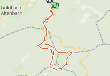
Tocht Stappen van 9,3 km beschikbaar op Grand Est, Haut-Rhin, Goldbach-Altenbach. Deze tocht wordt voorgesteld door helmut68.
Beschrijving
Randonnée à partir du Col Amic pour rejoindre le refuge du SC Cernay près de l'auberge du Molkenrein. Belle boucle qui permet de voir la partie sud des Vosges et la forêt noir,ainsi que des vestiges de la grande Guerre...
Plaatsbepaling
Land:
France
Regio :
Grand Est
Departement/Provincie :
Haut-Rhin
Gemeente :
Goldbach-Altenbach
Locatie:
Unknown
Vertrek:(Dec)
Vertrek:(UTM)
359945 ; 5303900 (32T) N.
Opmerkingen
Wandeltochten in de omgeving
![Tocht Stappen Soultz-Haut-Rhin - Hartmannswillerkopf - Circuit découverte - Photo](https://media.geolcdn.com/t/375/260/ext.jpg?maxdim=2&url=https%3A%2F%2Fservices.sitytrail.com%2FGeolivesWS%2FDownloadMedia.ashx%3FTrailID%3D422294%26Media%3Dfix__20150517124954.jpg)
![Stappen Stappen](https://static1.geolcdn.com/sitytour/trail-icons/101.png)
Hartmannswillerkopf - Circuit découverte
Stappen
Gemakkelijk
(1)
Soultz-Haut-Rhin,
Grand Est,
Haut-Rhin,
France
![](/images/other/stat-length.png)
3,6 km | 5,2 km-effort
1h 46min
![](https://static1.geolcdn.com/siteimages/upload/files/16400158638029165_repeat_loop_refresh_sync_direction_icon.png)
Ja
![Tocht Stappen Soultz-Haut-Rhin - Hartmannswillerkopf - Circuit anneau bleu - Photo](https://media.geolcdn.com/t/375/260/ext.jpg?maxdim=2&url=https%3A%2F%2Fservices.sitytrail.com%2FGeolivesWS%2FDownloadMedia.ashx%3FTrailID%3D422291%26Media%3Dfix__20150517150228.jpg)
![Stappen Stappen](https://static1.geolcdn.com/sitytour/trail-icons/101.png)
Hartmannswillerkopf - Circuit anneau bleu
Stappen
Medium
(1)
Soultz-Haut-Rhin,
Grand Est,
Haut-Rhin,
France
![](/images/other/stat-length.png)
3,7 km | 5,9 km-effort
1h 37min
![](https://static1.geolcdn.com/siteimages/upload/files/16400158638029165_repeat_loop_refresh_sync_direction_icon.png)
Ja
![Tocht Andere activiteiten Steinbach - lac du ballon - Photo](https://media.geolcdn.com/t/375/260/ext.jpg?maxdim=2&url=https%3A%2F%2Fservices.sitytrail.com%2FGeolivesWS%2FDownloadMedia.ashx%3FTrailID%3D210434%26Media%3Dfix__20130805111422.jpg)
![Andere activiteiten Andere activiteiten](https://static1.geolcdn.com/sitytour/trail-icons/900.png)
lac du ballon
Andere activiteiten
Heel gemakkelijk
(1)
Steinbach,
Grand Est,
Haut-Rhin,
France
![](/images/other/stat-length.png)
33 km | 64 km-effort
5h 1min
![](https://static1.geolcdn.com/siteimages/upload/files/16400158638029165_repeat_loop_refresh_sync_direction_icon.png)
Neen
![Tocht Te voet Goldbach-Altenbach - Firstacker - Willer sur Thur - Photo](https://media.geolcdn.com/t/375/260/203caa2b-07d7-4c6d-9f37-990a5db6b7c9.jpeg&format=jpg&maxdim=2)
![Te voet Te voet](https://static1.geolcdn.com/sitytour/trail-icons/100.png)
Firstacker - Willer sur Thur
Te voet
Gemakkelijk
Goldbach-Altenbach,
Grand Est,
Haut-Rhin,
France
![](/images/other/stat-length.png)
7,4 km | 9,6 km-effort
2h 11min
![](https://static1.geolcdn.com/siteimages/upload/files/16400158638029165_repeat_loop_refresh_sync_direction_icon.png)
Neen
![Tocht Trail Wattwiller - The History Ultra - stage 1 - Photo](https://media.geolcdn.com/t/375/260/ext.jpg?maxdim=2&url=https%3A%2F%2Fstatic1.geolcdn.com%2Fsiteimages%2Fupload%2Ffiles%2F1524743154running.jpg)
![Trail Trail](https://static1.geolcdn.com/sitytour/trail-icons/104.png)
The History Ultra - stage 1
Trail
Heel gemakkelijk
(1)
Wattwiller,
Grand Est,
Haut-Rhin,
France
![](/images/other/stat-length.png)
28 km | 48 km-effort
Onbekend
![](https://static1.geolcdn.com/siteimages/upload/files/16400158638029165_repeat_loop_refresh_sync_direction_icon.png)
Neen
![Tocht Te voet Bitschwiller-lès-Thann - Bitschwiller les Thann - Rehbrunnel - Abri du Becherkopf - Roche Albert - Photo](https://media.geolcdn.com/t/375/260/ext.jpg?maxdim=2&url=https%3A%2F%2Fstatic1.geolcdn.com%2Fsiteimages%2Fupload%2Ffiles%2F1545311037marcheuse_200dpi.jpg)
![Te voet Te voet](https://static1.geolcdn.com/sitytour/trail-icons/100.png)
Bitschwiller les Thann - Rehbrunnel - Abri du Becherkopf - Roche Albert
Te voet
Medium
(1)
Bitschwiller-lès-Thann,
Grand Est,
Haut-Rhin,
France
![](/images/other/stat-length.png)
10,3 km | 16,4 km-effort
Onbekend
![](https://static1.geolcdn.com/siteimages/upload/files/16400158638029165_repeat_loop_refresh_sync_direction_icon.png)
Ja
![Tocht Stappen Willer-sur-Thur - Spechtfest2025 - Photo](https://media.geolcdn.com/t/375/260/5eafed01-1af1-4202-ab8a-aebd0d9b1194.jpg&format=jpg&maxdim=2)
![Stappen Stappen](https://static1.geolcdn.com/sitytour/trail-icons/101.png)
Spechtfest2025
Stappen
Medium
Willer-sur-Thur,
Grand Est,
Haut-Rhin,
France
![](/images/other/stat-length.png)
134 km | 257 km-effort
2h 11min
![](https://static1.geolcdn.com/siteimages/upload/files/16400158638029165_repeat_loop_refresh_sync_direction_icon.png)
Neen
![Tocht Stappen Soultz-Haut-Rhin - Rando Marcheurs..04/04_2025 - Photo](https://media.geolcdn.com/t/375/260/2ab5dad5-2554-412a-abd7-9d4222ed2a04.jpg&format=jpg&maxdim=2)
![Stappen Stappen](https://static1.geolcdn.com/sitytour/trail-icons/101.png)
Rando Marcheurs..04/04_2025
Stappen
Zeer moeilijk
Soultz-Haut-Rhin,
Grand Est,
Haut-Rhin,
France
![](/images/other/stat-length.png)
21 km | 35 km-effort
4h 42min
![](https://static1.geolcdn.com/siteimages/upload/files/16400158638029165_repeat_loop_refresh_sync_direction_icon.png)
Ja
![Tocht Stappen Jungholtz - Rando Retrouvailles...01/03/2024.par Jean Marc - Photo](https://media.geolcdn.com/t/375/260/a9ee6325-7504-4fd2-a0fe-1e1c5b8164cc.jpg&format=jpg&maxdim=2)
![Stappen Stappen](https://static1.geolcdn.com/sitytour/trail-icons/101.png)
Rando Retrouvailles...01/03/2024.par Jean Marc
Stappen
Zeer moeilijk
Jungholtz,
Grand Est,
Haut-Rhin,
France
![](/images/other/stat-length.png)
11,3 km | 19,2 km-effort
1h 35min
![](https://static1.geolcdn.com/siteimages/upload/files/16400158638029165_repeat_loop_refresh_sync_direction_icon.png)
Ja