![](/images/other/stat-length.png)
![Tocht Stappen Aat - Autour du Blanc Moulin - Photo](https://media.geolcdn.com/t/1900/400/c159b44a-c495-40e0-8262-2de8c48bff7c.jpg&format=pjpeg&maxdim=2)
Autour du Blanc Moulin
rfnet
Gebruiker
![Lengte](/images/other/stat-length.png)
Lengte
7,2 km
![Max. hoogte](https://static1.geolcdn.com/siteimages/upload/files/1508320355ic_sort_altitude_max_24dp.png)
Max. hoogte
48 m
![Positief hoogteverschil](https://static1.geolcdn.com/siteimages/upload/files/1508320355ic_sort_den_pos_24dp.png)
Positief hoogteverschil
44 m
![Km-Effort](/images/other/stat-length.png)
Km-Effort
7,8 km
![Min. hoogte](https://static1.geolcdn.com/siteimages/upload/files/1508320355ic_sort_altitude_min_24dp.png)
Min. hoogte
26 m
![Negatief hoogteverschil](https://static1.geolcdn.com/siteimages/upload/files/1508320355ic_sort_den_neg_24dp.png)
Negatief hoogteverschil
46 m
![Boucle](https://static1.geolcdn.com/siteimages/upload/files/16400158638029165_repeat_loop_refresh_sync_direction_icon.png)
Boucle
Ja
Datum van aanmaak :
2019-08-18 14:14:43.199
Laatste wijziging :
2019-08-18 19:03:57.193
![Stappen](https://static1.geolcdn.com/sitytour/trail-icons/101.png)
2h00
Moeilijkheid : Heel gemakkelijk
![Scan deze QR-code om de tocht te openen in de SityTrail-applicatie](https://capi.geolives.com/qq0zvz2zws4bq2lad0pu/sitytour/trails/2175555/qr.png?size=200)
Gratisgps-wandelapplicatie
Over ons
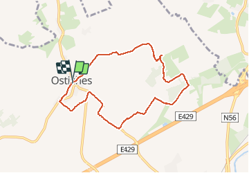
Tocht Stappen van 7,2 km beschikbaar op Wallonië, Henegouwen, Aat. Deze tocht wordt voorgesteld door rfnet.
Beschrijving
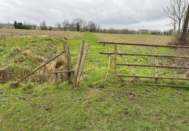
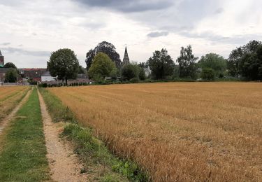
Petite balade dominicale dans le beau village d'Ostiche, autour de son emblématique moulin à vent. Pas de difficultés particulières, une partie sur chemin agricole défoncé qui peut engendrer des entorses. Sur route en général pas d'accotement pour piéton.
Plaatsbepaling
Land:
Belgium
Regio :
Wallonië
Departement/Provincie :
Henegouwen
Gemeente :
Aat
Locatie:
Ostiches
Vertrek:(Dec)
Vertrek:(UTM)
553605 ; 5614326 (31U) N.
Opmerkingen
Wandeltochten in de omgeving
![Tocht Te voet Elzele - Wandeling Jean Nature - Photo](https://media.geolcdn.com/t/375/260/ext.jpg?maxdim=2&url=https%3A%2F%2Fpivotmedia.tourismewallonie.be%2FANX-02-03ZF-0001%2FANX-02-03ZF-0001.JPG)
![Te voet Te voet](https://static1.geolcdn.com/sitytour/trail-icons/100.png)
Wandeling Jean Nature
Te voet
Gemakkelijk
(1)
Elzele,
Wallonië,
Henegouwen,
Belgium
![](/images/other/stat-length.png)
9,2 km | 10,3 km-effort
2h 20min
![](https://static1.geolcdn.com/siteimages/upload/files/16400158638029165_repeat_loop_refresh_sync_direction_icon.png)
Ja
![Tocht Te voet Elzele - Wandeling in het Pays de Petite Elle' - Photo](https://media.geolcdn.com/t/375/260/ext.jpg?maxdim=2&url=https%3A%2F%2Fpivotmedia.tourismewallonie.be%2FANX-02-000EMF%2FANX-02-000EMF.jpg)
![Te voet Te voet](https://static1.geolcdn.com/sitytour/trail-icons/100.png)
Wandeling in het Pays de Petite Elle'
Te voet
Gemakkelijk
Elzele,
Wallonië,
Henegouwen,
Belgium
![](/images/other/stat-length.png)
15,1 km | 17,1 km-effort
3h 53min
![](https://static1.geolcdn.com/siteimages/upload/files/16400158638029165_repeat_loop_refresh_sync_direction_icon.png)
Neen
![Tocht Te voet Aat - De Ronde van de Blanc Moulin - Photo](https://media.geolcdn.com/t/375/260/ext.jpg?maxdim=2&url=https%3A%2F%2Fpivotmedia.tourismewallonie.be%2FANX-02-000ELT%2FANX-02-000ELT.jpg)
![Te voet Te voet](https://static1.geolcdn.com/sitytour/trail-icons/100.png)
De Ronde van de Blanc Moulin
Te voet
Gemakkelijk
(1)
Aat,
Wallonië,
Henegouwen,
Belgium
![](/images/other/stat-length.png)
7,1 km | 7,7 km-effort
1h 44min
![](https://static1.geolcdn.com/siteimages/upload/files/16400158638029165_repeat_loop_refresh_sync_direction_icon.png)
Ja
![Tocht Te voet Aat - Het Molencircuit - Photo](https://media.geolcdn.com/t/375/260/ext.jpg?maxdim=2&url=https%3A%2F%2Fpivotmedia.tourismewallonie.be%2FANX-02-000EOC%2FANX-02-000EOC.jpg)
![Te voet Te voet](https://static1.geolcdn.com/sitytour/trail-icons/100.png)
Het Molencircuit
Te voet
Medium
Aat,
Wallonië,
Henegouwen,
Belgium
![](/images/other/stat-length.png)
19,4 km | 22 km-effort
4h 54min
![](https://static1.geolcdn.com/siteimages/upload/files/16400158638029165_repeat_loop_refresh_sync_direction_icon.png)
Ja
![Tocht Te voet Aat - Circuit van de Dendervlakte - Photo](https://media.geolcdn.com/t/375/260/ext.jpg?maxdim=2&url=https%3A%2F%2Fpivotmedia.tourismewallonie.be%2FANX-02-000ESY%2FANX-02-000ESY.jpg)
![Te voet Te voet](https://static1.geolcdn.com/sitytour/trail-icons/100.png)
Circuit van de Dendervlakte
Te voet
Gemakkelijk
(1)
Aat,
Wallonië,
Henegouwen,
Belgium
![](/images/other/stat-length.png)
8,9 km | 9,7 km-effort
2h 12min
![](https://static1.geolcdn.com/siteimages/upload/files/16400158638029165_repeat_loop_refresh_sync_direction_icon.png)
Ja
![Tocht Stappen Elzele - La Hamaide 10 km - Photo](https://media.geolcdn.com/t/375/260/5dfdbe2a-fdba-4ebf-8ef1-c02506e9fb9f.jpg&format=jpg&maxdim=2)
![Stappen Stappen](https://static1.geolcdn.com/sitytour/trail-icons/101.png)
La Hamaide 10 km
Stappen
Gemakkelijk
Elzele,
Wallonië,
Henegouwen,
Belgium
![](/images/other/stat-length.png)
10,2 km | 11,5 km-effort
2h 23min
![](https://static1.geolcdn.com/siteimages/upload/files/16400158638029165_repeat_loop_refresh_sync_direction_icon.png)
Ja
![Tocht Stappen Elzele - Wodeeck - Photo](https://media.geolcdn.com/t/375/260/ext.jpg?maxdim=2&url=https%3A%2F%2Fstatic1.geolcdn.com%2Fsiteimages%2Fupload%2Ffiles%2F1553511878bg_sport_marche.png)
![Stappen Stappen](https://static1.geolcdn.com/sitytour/trail-icons/101.png)
Wodeeck
Stappen
Heel gemakkelijk
(2)
Elzele,
Wallonië,
Henegouwen,
Belgium
![](/images/other/stat-length.png)
7,6 km | 8,5 km-effort
2h 2min
![](https://static1.geolcdn.com/siteimages/upload/files/16400158638029165_repeat_loop_refresh_sync_direction_icon.png)
Ja
![Tocht Stappen Elzele - Lahamaide 10,6 km - Photo](https://media.geolcdn.com/t/375/260/e3696fea-37a8-48b8-a225-5f4251c75024.jpg&format=jpg&maxdim=2)
![Stappen Stappen](https://static1.geolcdn.com/sitytour/trail-icons/101.png)
Lahamaide 10,6 km
Stappen
Gemakkelijk
Elzele,
Wallonië,
Henegouwen,
Belgium
![](/images/other/stat-length.png)
10,6 km | 12 km-effort
2h 33min
![](https://static1.geolcdn.com/siteimages/upload/files/16400158638029165_repeat_loop_refresh_sync_direction_icon.png)
Ja
![Tocht Stappen Aat - Houtaing 170824 - Photo](https://media.geolcdn.com/t/375/260/f12fc937-810e-41c5-a4d1-7070640c4fea.jpg&format=jpg&maxdim=2)
![Stappen Stappen](https://static1.geolcdn.com/sitytour/trail-icons/101.png)
Houtaing 170824
Stappen
Medium
Aat,
Wallonië,
Henegouwen,
Belgium
![](/images/other/stat-length.png)
5,3 km | 6,2 km-effort
1h 21min
![](https://static1.geolcdn.com/siteimages/upload/files/16400158638029165_repeat_loop_refresh_sync_direction_icon.png)
Ja