![](/images/other/stat-length.png)
![Tocht Hybride fiets Nancy - Bord de la Meurthe - Photo](https://media.geolcdn.com/t/1900/400/ext.pjpeg?maxdim=2&url=https%3A%2F%2Fstatic1.geolcdn.com%2Fsiteimages%2Fupload%2Ffiles%2F1524743154velo.jpg)
Bord de la Meurthe
Greg813
Gebruiker
![Lengte](/images/other/stat-length.png)
Lengte
30 km
![Max. hoogte](https://static1.geolcdn.com/siteimages/upload/files/1508320355ic_sort_altitude_max_24dp.png)
Max. hoogte
232 m
![Positief hoogteverschil](https://static1.geolcdn.com/siteimages/upload/files/1508320355ic_sort_den_pos_24dp.png)
Positief hoogteverschil
206 m
![Km-Effort](/images/other/stat-length.png)
Km-Effort
33 km
![Min. hoogte](https://static1.geolcdn.com/siteimages/upload/files/1508320355ic_sort_altitude_min_24dp.png)
Min. hoogte
183 m
![Negatief hoogteverschil](https://static1.geolcdn.com/siteimages/upload/files/1508320355ic_sort_den_neg_24dp.png)
Negatief hoogteverschil
211 m
![Boucle](https://static1.geolcdn.com/siteimages/upload/files/16400158638029165_repeat_loop_refresh_sync_direction_icon.png)
Boucle
Ja
Datum van aanmaak :
2019-08-15 12:28:31.704
Laatste wijziging :
2019-08-15 16:22:55.913
![Hybride fiets](https://static1.geolcdn.com/sitytour/trail-icons/203.png)
1h55
Moeilijkheid : Gemakkelijk
![Scan deze QR-code om de tocht te openen in de SityTrail-applicatie](https://capi.geolives.com/qq0zvz2zws4bq2lad0pu/sitytour/trails/2171773/qr.png?size=200)
Gratisgps-wandelapplicatie
Over ons
Tocht Hybride fiets van 30 km beschikbaar op Grand Est, Meurthe-et-Moselle, Nancy. Deze tocht wordt voorgesteld door Greg813.
Beschrijving
Ballade plutôt plate pour VTC (le VTT n'est pas nécessaire mais le vélo de route n'est pas suffisant).
Descente vers Frouard sur le chemin de halage le long du canal et montée le long de la Meurthe sur la piste cyclable en grande partie goudronnée.
Plaatsbepaling
Land:
France
Regio :
Grand Est
Departement/Provincie :
Meurthe-et-Moselle
Gemeente :
Nancy
Locatie:
Unknown
Vertrek:(Dec)
Vertrek:(UTM)
292313 ; 5395162 (32U) N.
Opmerkingen
Wandeltochten in de omgeving
![Tocht Te voet Agincourt - Circuit M - Photo](https://media.geolcdn.com/t/375/260/af3027bd-6d38-4135-8a9f-8cca4de624d0.jpeg&format=jpg&maxdim=2)
![Te voet Te voet](https://static1.geolcdn.com/sitytour/trail-icons/100.png)
Circuit M
Te voet
Gemakkelijk
Agincourt,
Grand Est,
Meurthe-et-Moselle,
France
![](/images/other/stat-length.png)
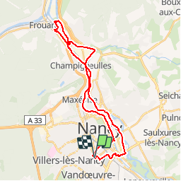
13,3 km | 17,8 km-effort
4h 3min
![](https://static1.geolcdn.com/siteimages/upload/files/16400158638029165_repeat_loop_refresh_sync_direction_icon.png)
Neen
![Tocht Te voet Champigneulles - Circuit du Noirval - Photo](https://media.geolcdn.com/t/375/260/199ee8e6-f9b7-4be8-9188-093275697409.jpeg&format=jpg&maxdim=2)
![Te voet Te voet](https://static1.geolcdn.com/sitytour/trail-icons/100.png)
Circuit du Noirval
Te voet
Gemakkelijk
Champigneulles,
Grand Est,
Meurthe-et-Moselle,
France
![](/images/other/stat-length.png)
11,1 km | 13,5 km-effort
3h 4min
![](https://static1.geolcdn.com/siteimages/upload/files/16400158638029165_repeat_loop_refresh_sync_direction_icon.png)
Ja
![Tocht Stappen Nancy - Ma dernière avant opération - Photo](https://media.geolcdn.com/t/375/260/ext.jpg?maxdim=2&url=https%3A%2F%2Fstatic1.geolcdn.com%2Fsiteimages%2Fupload%2Ffiles%2F1553511878bg_sport_marche.png)
![Stappen Stappen](https://static1.geolcdn.com/sitytour/trail-icons/101.png)
Ma dernière avant opération
Stappen
Zeer moeilijk
(1)
Nancy,
Grand Est,
Meurthe-et-Moselle,
France
![](/images/other/stat-length.png)
22 km | 25 km-effort
4h 12min
![](https://static1.geolcdn.com/siteimages/upload/files/16400158638029165_repeat_loop_refresh_sync_direction_icon.png)
Ja
![Tocht Stappen Vandœuvre-lès-Nancy - Randonnée USEP 2023 - Photo](https://media.geolcdn.com/t/375/260/ext.jpg?maxdim=2&url=https%3A%2F%2Fstatic1.geolcdn.com%2Fsiteimages%2Fupload%2Ffiles%2F1553511878bg_sport_marche.png)
![Stappen Stappen](https://static1.geolcdn.com/sitytour/trail-icons/101.png)
Randonnée USEP 2023
Stappen
Moeilijk
(1)
Vandœuvre-lès-Nancy,
Grand Est,
Meurthe-et-Moselle,
France
![](/images/other/stat-length.png)
11,7 km | 15,2 km-effort
3h 27min
![](https://static1.geolcdn.com/siteimages/upload/files/16400158638029165_repeat_loop_refresh_sync_direction_icon.png)
Neen
![Tocht Stappen Nancy - Ma rando du jour - Photo](https://media.geolcdn.com/t/375/260/c990ad83-2661-43f9-99e0-4498fd5d020a.jpg&format=jpg&maxdim=2)
![Stappen Stappen](https://static1.geolcdn.com/sitytour/trail-icons/101.png)
Ma rando du jour
Stappen
Moeilijk
Nancy,
Grand Est,
Meurthe-et-Moselle,
France
![](/images/other/stat-length.png)
35 km | 41 km-effort
5h 55min
![](https://static1.geolcdn.com/siteimages/upload/files/16400158638029165_repeat_loop_refresh_sync_direction_icon.png)
Ja
![Tocht Stappen Nancy - Nancy Gondreville Nancy - Photo](https://media.geolcdn.com/t/375/260/171b4f53-1717-4b2e-9789-6c40dd8e1481.jpg&format=jpg&maxdim=2)
![Stappen Stappen](https://static1.geolcdn.com/sitytour/trail-icons/101.png)
Nancy Gondreville Nancy
Stappen
Moeilijk
Nancy,
Grand Est,
Meurthe-et-Moselle,
France
![](/images/other/stat-length.png)
64 km | 74 km-effort
10h 57min
![](https://static1.geolcdn.com/siteimages/upload/files/16400158638029165_repeat_loop_refresh_sync_direction_icon.png)
Ja
![Tocht Stappen Nancy - Nancy Saizeray Jaillon Pierre la Treiche Marion Nancy - Photo](https://media.geolcdn.com/t/375/260/9e40712a-6db3-4fe8-9edd-58851d16cb4f.jpg&format=jpg&maxdim=2)
![Stappen Stappen](https://static1.geolcdn.com/sitytour/trail-icons/101.png)
Nancy Saizeray Jaillon Pierre la Treiche Marion Nancy
Stappen
Moeilijk
Nancy,
Grand Est,
Meurthe-et-Moselle,
France
![](/images/other/stat-length.png)
73 km | 85 km-effort
12h 13min
![](https://static1.geolcdn.com/siteimages/upload/files/16400158638029165_repeat_loop_refresh_sync_direction_icon.png)
Ja
![Tocht Te voet Villers-lès-Nancy - Promenade d'Hardeval - Photo](https://media.geolcdn.com/t/375/260/43cb5da8-59dd-45f8-ae11-ca17f70000c7.jpeg&format=jpg&maxdim=2)
![Te voet Te voet](https://static1.geolcdn.com/sitytour/trail-icons/100.png)
Promenade d'Hardeval
Te voet
Gemakkelijk
Villers-lès-Nancy,
Grand Est,
Meurthe-et-Moselle,
France
![](/images/other/stat-length.png)
3,2 km | 4,3 km-effort
58min
![](https://static1.geolcdn.com/siteimages/upload/files/16400158638029165_repeat_loop_refresh_sync_direction_icon.png)
Ja
![Tocht Stappen Nancy - Nancy - Gondreville - Nancy - Photo](https://media.geolcdn.com/t/375/260/1ba94617-550e-4800-a823-8e357aef3619.jpg&format=jpg&maxdim=2)
![Stappen Stappen](https://static1.geolcdn.com/sitytour/trail-icons/101.png)
Nancy - Gondreville - Nancy
Stappen
Medium
Nancy,
Grand Est,
Meurthe-et-Moselle,
France
![](/images/other/stat-length.png)
64 km | 74 km-effort
24h 59min
![](https://static1.geolcdn.com/siteimages/upload/files/16400158638029165_repeat_loop_refresh_sync_direction_icon.png)
Ja