![](/images/other/stat-length.png)
![Tocht Mountainbike Bassins - Les Pralets - Place d'Armes - Rionde Dessus - Le Vaud - Photo](https://media.geolcdn.com/t/1900/400/ext.pjpeg?maxdim=2&url=https%3A%2F%2Fstatic1.geolcdn.com%2Fsiteimages%2Fupload%2Ffiles%2F1524743154velo.jpg)
Les Pralets - Place d'Armes - Rionde Dessus - Le Vaud
tonymeyer
Gebruiker
![Lengte](/images/other/stat-length.png)
Lengte
23 km
![Max. hoogte](https://static1.geolcdn.com/siteimages/upload/files/1508320355ic_sort_altitude_max_24dp.png)
Max. hoogte
1514 m
![Positief hoogteverschil](https://static1.geolcdn.com/siteimages/upload/files/1508320355ic_sort_den_pos_24dp.png)
Positief hoogteverschil
446 m
![Km-Effort](/images/other/stat-length.png)
Km-Effort
30 km
![Min. hoogte](https://static1.geolcdn.com/siteimages/upload/files/1508320355ic_sort_altitude_min_24dp.png)
Min. hoogte
801 m
![Negatief hoogteverschil](https://static1.geolcdn.com/siteimages/upload/files/1508320355ic_sort_den_neg_24dp.png)
Negatief hoogteverschil
916 m
![Boucle](https://static1.geolcdn.com/siteimages/upload/files/16400158638029165_repeat_loop_refresh_sync_direction_icon.png)
Boucle
Neen
Datum van aanmaak :
2014-12-10 00:00:00.0
Laatste wijziging :
2014-12-10 00:00:00.0
![Mountainbike](https://static1.geolcdn.com/sitytour/trail-icons/202.png)
2h19
Moeilijkheid : Medium
![Scan deze QR-code om de tocht te openen in de SityTrail-applicatie](https://capi.geolives.com/qq0zvz2zws4bq2lad0pu/sitytour/trails/216916/qr.png?size=200)
Gratisgps-wandelapplicatie
Over ons
Tocht Mountainbike van 23 km beschikbaar op Waadland, District de Nyon, Bassins. Deze tocht wordt voorgesteld door tonymeyer.
Beschrijving
Monter depuis Bassins par la Rte de la Montagne et lasser la voiture à l'altitude 1263m sur la route de la Montagne, près des Pralets.
Plaatsbepaling
Land:
Switzerland
Regio :
Waadland
Departement/Provincie :
District de Nyon
Gemeente :
Bassins
Locatie:
Unknown
Vertrek:(Dec)
Vertrek:(UTM)
283402 ; 5153611 (32T) N.
Opmerkingen
Wandeltochten in de omgeving
![Tocht Stappen Bois-d'Amont - Roche Bernard - Bois d'Amont - Photo](https://media.geolcdn.com/t/375/260/ext.jpg?maxdim=2&url=https%3A%2F%2Fservices.sitytrail.com%2FGeolivesWS%2FDownloadMedia.ashx%3FTrailID%3D191461%26Media%3D15055_5.jpg)
![Stappen Stappen](https://static1.geolcdn.com/sitytour/trail-icons/101.png)
Roche Bernard - Bois d'Amont
Stappen
Moeilijk
(1)
Bois-d'Amont,
Bourgondië-Franche-Comté,
Jura,
France
![](/images/other/stat-length.png)
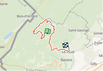
15,1 km | 21 km-effort
5h 0min
![](https://static1.geolcdn.com/siteimages/upload/files/16400158638029165_repeat_loop_refresh_sync_direction_icon.png)
Ja
![Tocht Stappen Bois-d'Amont - La Roche du Creux - Bois d'Amont - Photo](https://media.geolcdn.com/t/375/260/ext.jpg?maxdim=2&url=https%3A%2F%2Fservices.sitytrail.com%2FGeolivesWS%2FDownloadMedia.ashx%3FTrailID%3D191433%26Media%3D15020_5.jpg)
![Stappen Stappen](https://static1.geolcdn.com/sitytour/trail-icons/101.png)
La Roche du Creux - Bois d'Amont
Stappen
Medium
(1)
Bois-d'Amont,
Bourgondië-Franche-Comté,
Jura,
France
![](/images/other/stat-length.png)
8,7 km | 12,1 km-effort
3h 0min
![](https://static1.geolcdn.com/siteimages/upload/files/16400158638029165_repeat_loop_refresh_sync_direction_icon.png)
Ja
![Tocht Stappen Bois-d'Amont - Le Mont Sâla - Bois d'Amont - Photo](https://media.geolcdn.com/t/375/260/ext.jpg?maxdim=2&url=https%3A%2F%2Fservices.sitytrail.com%2FGeolivesWS%2FDownloadMedia.ashx%3FTrailID%3D191430%26Media%3D15016_5.jpg)
![Stappen Stappen](https://static1.geolcdn.com/sitytour/trail-icons/101.png)
Le Mont Sâla - Bois d'Amont
Stappen
Zeer moeilijk
(1)
Bois-d'Amont,
Bourgondië-Franche-Comté,
Jura,
France
![](/images/other/stat-length.png)
14,3 km | 22 km-effort
4h 30min
![](https://static1.geolcdn.com/siteimages/upload/files/16400158638029165_repeat_loop_refresh_sync_direction_icon.png)
Ja
![Tocht Stappen Bois-d'Amont - Le Livre d'Or du Risoux - Bois d'Amont - Photo](https://media.geolcdn.com/t/375/260/ext.jpg?maxdim=2&url=https%3A%2F%2Fservices.sitytrail.com%2FGeolivesWS%2FDownloadMedia.ashx%3FTrailID%3D191405%26Media%3D14979_6.jpg)
![Stappen Stappen](https://static1.geolcdn.com/sitytour/trail-icons/101.png)
Le Livre d'Or du Risoux - Bois d'Amont
Stappen
Zeer moeilijk
(1)
Bois-d'Amont,
Bourgondië-Franche-Comté,
Jura,
France
![](/images/other/stat-length.png)
17,7 km | 24 km-effort
6h 40min
![](https://static1.geolcdn.com/siteimages/upload/files/16400158638029165_repeat_loop_refresh_sync_direction_icon.png)
Ja
![Tocht Te voet Bois-d'Amont - La Chaux Sèche - Photo](https://media.geolcdn.com/t/375/260/ext.jpg?maxdim=2&url=https%3A%2F%2Fmedia.geolcdn.com%2Ff%2F67130a55-87b2-4c49-bad2-80f6e845a64b.jpeg)
![Te voet Te voet](https://static1.geolcdn.com/sitytour/trail-icons/100.png)
La Chaux Sèche
Te voet
Gemakkelijk
Bois-d'Amont,
Bourgondië-Franche-Comté,
Jura,
France
![](/images/other/stat-length.png)
10,1 km | 13,9 km-effort
3h 9min
![](https://static1.geolcdn.com/siteimages/upload/files/16400158638029165_repeat_loop_refresh_sync_direction_icon.png)
Ja
![Tocht Te voet Marchissy - Sentier du Coq - Photo](https://media.geolcdn.com/t/375/260/ext.jpg?maxdim=2&url=https%3A%2F%2Fmedia.geolcdn.com%2Ff%2F8a5237db-6f33-409f-bb3a-20fc00640a5b.jpeg)
![Te voet Te voet](https://static1.geolcdn.com/sitytour/trail-icons/100.png)
Sentier du Coq
Te voet
Gemakkelijk
Marchissy,
Waadland,
District de Nyon,
Switzerland
![](/images/other/stat-length.png)
5,7 km | 11,2 km-effort
2h 32min
![](https://static1.geolcdn.com/siteimages/upload/files/16400158638029165_repeat_loop_refresh_sync_direction_icon.png)
Neen
![Tocht Stappen Bassins - Creux du Croue depuis route des Pralets - Photo](https://media.geolcdn.com/t/375/260/ext.jpg?maxdim=2&url=https%3A%2F%2Fservices.sitytrail.com%2FGeolivesWS%2FDownloadMedia.ashx%3FTrailID%3D843799%26Media%3D20171010161753.jpg)
![Stappen Stappen](https://static1.geolcdn.com/sitytour/trail-icons/101.png)
Creux du Croue depuis route des Pralets
Stappen
Gemakkelijk
Bassins,
Waadland,
District de Nyon,
Switzerland
![](/images/other/stat-length.png)
14,5 km | 21 km-effort
4h 16min
![](https://static1.geolcdn.com/siteimages/upload/files/16400158638029165_repeat_loop_refresh_sync_direction_icon.png)
Ja
![Tocht Stappen Bassins - Le Sentier des Begnines - Photo](https://media.geolcdn.com/t/375/260/ext.jpg?maxdim=2&url=https%3A%2F%2Fservices.sitytrail.com%2FGeolivesWS%2FDownloadMedia.ashx%3FTrailID%3D471164%26Media%3D20150912143228.jpg)
![Stappen Stappen](https://static1.geolcdn.com/sitytour/trail-icons/101.png)
Le Sentier des Begnines
Stappen
Gemakkelijk
Bassins,
Waadland,
District de Nyon,
Switzerland
![](/images/other/stat-length.png)
14,9 km | 21 km-effort
4h 0min
![](https://static1.geolcdn.com/siteimages/upload/files/16400158638029165_repeat_loop_refresh_sync_direction_icon.png)
Ja
![Tocht Fiets Bois-d'Amont - Tour du Lac de Joux - Bois d'Amont - Photo](https://media.geolcdn.com/t/375/260/ext.jpg?maxdim=2&url=https%3A%2F%2Fservices.sitytrail.com%2FGeolivesWS%2FDownloadMedia.ashx%3FTrailID%3D317409%26Media%3D16631_5.jpg)
![Fiets Fiets](https://static1.geolcdn.com/sitytour/trail-icons/200.png)
Tour du Lac de Joux - Bois d'Amont
Fiets
Medium
Bois-d'Amont,
Bourgondië-Franche-Comté,
Jura,
France
![](/images/other/stat-length.png)
45 km | 51 km-effort
2h 0min
![](https://static1.geolcdn.com/siteimages/upload/files/16400158638029165_repeat_loop_refresh_sync_direction_icon.png)
Ja