![](/images/other/stat-length.png)
![Tocht Mountainbike Épaney - Sortie Marathon Rando Condé départ de Epaney - Photo](https://media.geolcdn.com/t/1900/400/ext.pjpeg?maxdim=2&url=https%3A%2F%2Fservices.sitytrail.com%2FGeolivesWS%2FDownloadMedia.ashx%3FTrailID%3D215148%26Media%3D15743_1.jpg)
Sortie Marathon Rando Condé départ de Epaney
tracegps
Gebruiker
![Lengte](/images/other/stat-length.png)
Lengte
132 km
![Max. hoogte](https://static1.geolcdn.com/siteimages/upload/files/1508320355ic_sort_altitude_max_24dp.png)
Max. hoogte
250 m
![Positief hoogteverschil](https://static1.geolcdn.com/siteimages/upload/files/1508320355ic_sort_den_pos_24dp.png)
Positief hoogteverschil
2431 m
![Km-Effort](/images/other/stat-length.png)
Km-Effort
164 km
![Min. hoogte](https://static1.geolcdn.com/siteimages/upload/files/1508320355ic_sort_altitude_min_24dp.png)
Min. hoogte
48 m
![Negatief hoogteverschil](https://static1.geolcdn.com/siteimages/upload/files/1508320355ic_sort_den_neg_24dp.png)
Negatief hoogteverschil
2430 m
![Boucle](https://static1.geolcdn.com/siteimages/upload/files/16400158638029165_repeat_loop_refresh_sync_direction_icon.png)
Boucle
Ja
Datum van aanmaak :
2014-12-10 00:00:00.0
Laatste wijziging :
2014-12-10 00:00:00.0
![Mountainbike](https://static1.geolcdn.com/sitytour/trail-icons/202.png)
7h30
Moeilijkheid : Moeilijk
![Scan deze QR-code om de tocht te openen in de SityTrail-applicatie](https://capi.geolives.com/qq0zvz2zws4bq2lad0pu/sitytour/trails/215148/qr.png?size=200)
Gratisgps-wandelapplicatie
Over ons
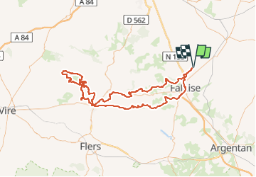
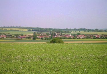
Tocht Mountainbike van 132 km beschikbaar op Normandië, Calvados, Épaney. Deze tocht wordt voorgesteld door tracegps.
Beschrijving
Très longue distance réalisée lors de la rando de Condé/Noireau en partant d'Epaney. A faire de préférence par beau temps et avec de bonnes jambes...
Plaatsbepaling
Land:
France
Regio :
Normandië
Departement/Provincie :
Calvados
Gemeente :
Épaney
Locatie:
Unknown
Vertrek:(Dec)
Vertrek:(UTM)
707319 ; 5425545 (30U) N.
Opmerkingen
Wandeltochten in de omgeving
![Tocht Stappen Damblainville - ERAINES 2 - Photo](https://media.geolcdn.com/t/375/260/ext.jpg?maxdim=2&url=https%3A%2F%2Fstatic1.geolcdn.com%2Fsiteimages%2Fupload%2Ffiles%2F1553511878bg_sport_marche.png)
![Stappen Stappen](https://static1.geolcdn.com/sitytour/trail-icons/101.png)
ERAINES 2
Stappen
Medium
(1)
Damblainville,
Normandië,
Calvados,
France
![](/images/other/stat-length.png)
9,8 km | 11,6 km-effort
2h 37min
![](https://static1.geolcdn.com/siteimages/upload/files/16400158638029165_repeat_loop_refresh_sync_direction_icon.png)
Ja
![Tocht Te voet Potigny - Circuit de la Brèche au Diable - Photo](https://media.geolcdn.com/t/375/260/bb5f5198-9d15-42be-9881-b093a943d0fa.jpeg&format=jpg&maxdim=2)
![Te voet Te voet](https://static1.geolcdn.com/sitytour/trail-icons/100.png)
Circuit de la Brèche au Diable
Te voet
Gemakkelijk
Potigny,
Normandië,
Calvados,
France
![](/images/other/stat-length.png)
11,9 km | 14,5 km-effort
3h 18min
![](https://static1.geolcdn.com/siteimages/upload/files/16400158638029165_repeat_loop_refresh_sync_direction_icon.png)
Ja
![Tocht Te voet Épaney - Circuit des 4 Vents - Photo](https://media.geolcdn.com/t/375/260/1a2ed606-6fdc-4d5c-97b8-eb9f481673a4.jpeg&format=jpg&maxdim=2)
![Te voet Te voet](https://static1.geolcdn.com/sitytour/trail-icons/100.png)
Circuit des 4 Vents
Te voet
Medium
Épaney,
Normandië,
Calvados,
France
![](/images/other/stat-length.png)
20 km | 23 km-effort
5h 16min
![](https://static1.geolcdn.com/siteimages/upload/files/16400158638029165_repeat_loop_refresh_sync_direction_icon.png)
Ja
![Tocht Te voet Versainville - Circuit des Orchidées - Photo](https://media.geolcdn.com/t/375/260/c335fda3-1637-437f-8279-41f4bb70e366.jpeg&format=jpg&maxdim=2)
![Te voet Te voet](https://static1.geolcdn.com/sitytour/trail-icons/100.png)
Circuit des Orchidées
Te voet
Gemakkelijk
Versainville,
Normandië,
Calvados,
France
![](/images/other/stat-length.png)
11,2 km | 13,2 km-effort
3h 0min
![](https://static1.geolcdn.com/siteimages/upload/files/16400158638029165_repeat_loop_refresh_sync_direction_icon.png)
Ja
![Tocht Mountainbike Épaney - 105 km au sud de Falaise - Epaney - Photo](https://media.geolcdn.com/t/375/260/ext.jpg?maxdim=2&url=https%3A%2F%2Fservices.sitytrail.com%2FGeolivesWS%2FDownloadMedia.ashx%3FTrailID%3D316943%26Media%3D16055_6.jpg)
![Mountainbike Mountainbike](https://static1.geolcdn.com/sitytour/trail-icons/202.png)
105 km au sud de Falaise - Epaney
Mountainbike
Moeilijk
Épaney,
Normandië,
Calvados,
France
![](/images/other/stat-length.png)
104 km | 127 km-effort
6h 0min
![](https://static1.geolcdn.com/siteimages/upload/files/16400158638029165_repeat_loop_refresh_sync_direction_icon.png)
Ja
![Tocht Mountainbike Épaney - Les chemins du Minerai - Epaney - Photo](https://media.geolcdn.com/t/375/260/ext.jpg?maxdim=2&url=https%3A%2F%2Fservices.sitytrail.com%2FGeolivesWS%2FDownloadMedia.ashx%3FTrailID%3D316933%26Media%3D16040_6.jpg)
![Mountainbike Mountainbike](https://static1.geolcdn.com/sitytour/trail-icons/202.png)
Les chemins du Minerai - Epaney
Mountainbike
Medium
Épaney,
Normandië,
Calvados,
France
![](/images/other/stat-length.png)
69 km | 80 km-effort
3h 30min
![](https://static1.geolcdn.com/siteimages/upload/files/16400158638029165_repeat_loop_refresh_sync_direction_icon.png)
Ja
![Tocht Te voet Épaney - Circuit du Lavoir - Photo](https://media.geolcdn.com/t/375/260/1a2ed606-6fdc-4d5c-97b8-eb9f481673a4.jpeg&format=jpg&maxdim=2)
![Te voet Te voet](https://static1.geolcdn.com/sitytour/trail-icons/100.png)
Circuit du Lavoir
Te voet
Gemakkelijk
Épaney,
Normandië,
Calvados,
France
![](/images/other/stat-length.png)
9,2 km | 10,4 km-effort
2h 21min
![](https://static1.geolcdn.com/siteimages/upload/files/16400158638029165_repeat_loop_refresh_sync_direction_icon.png)
Ja
![Tocht Te voet Soumont-Saint-Quentin - 2020-09-10_14h10m14_la breche au diable - Photo](https://media.geolcdn.com/t/375/260/82bf557f-9f58-4287-a4b4-71e42d9ee496.jpg&format=jpg&maxdim=2)
![Te voet Te voet](https://static1.geolcdn.com/sitytour/trail-icons/100.png)
2020-09-10_14h10m14_la breche au diable
Te voet
Gemakkelijk
(1)
Soumont-Saint-Quentin,
Normandië,
Calvados,
France
![](/images/other/stat-length.png)
9,1 km | 11,6 km-effort
Onbekend
![](https://static1.geolcdn.com/siteimages/upload/files/16400158638029165_repeat_loop_refresh_sync_direction_icon.png)
Ja
![Tocht Mountainbike Épaney - La trace des Celtes - Epaney - Photo](https://media.geolcdn.com/t/375/260/ext.jpg?maxdim=2&url=https%3A%2F%2Fservices.sitytrail.com%2FGeolivesWS%2FDownloadMedia.ashx%3FTrailID%3D215091%26Media%3D15668_2.jpg)
![Mountainbike Mountainbike](https://static1.geolcdn.com/sitytour/trail-icons/202.png)
La trace des Celtes - Epaney
Mountainbike
Medium
Épaney,
Normandië,
Calvados,
France
![](/images/other/stat-length.png)
59 km | 69 km-effort
3h 0min
![](https://static1.geolcdn.com/siteimages/upload/files/16400158638029165_repeat_loop_refresh_sync_direction_icon.png)
Ja