![](/images/other/stat-length.png)
![Tocht Fiets Dole - Tour du Jura à vélo version loisirs - Dole - Photo](https://media.geolcdn.com/t/1900/400/ext.pjpeg?maxdim=2&url=https%3A%2F%2Fservices.sitytrail.com%2FGeolivesWS%2FDownloadMedia.ashx%3FTrailID%3D215064%26Media%3D15637_5.jpg)
Tour du Jura à vélo version loisirs - Dole
tracegps
Gebruiker
![Lengte](/images/other/stat-length.png)
![Max. hoogte](https://static1.geolcdn.com/siteimages/upload/files/1508320355ic_sort_altitude_max_24dp.png)
![Positief hoogteverschil](https://static1.geolcdn.com/siteimages/upload/files/1508320355ic_sort_den_pos_24dp.png)
![Km-Effort](/images/other/stat-length.png)
![Min. hoogte](https://static1.geolcdn.com/siteimages/upload/files/1508320355ic_sort_altitude_min_24dp.png)
![Negatief hoogteverschil](https://static1.geolcdn.com/siteimages/upload/files/1508320355ic_sort_den_neg_24dp.png)
![Boucle](https://static1.geolcdn.com/siteimages/upload/files/16400158638029165_repeat_loop_refresh_sync_direction_icon.png)
![Fiets](https://static1.geolcdn.com/sitytour/trail-icons/200.png)
12h00
Moeilijkheid : Medium
![Scan deze QR-code om de tocht te openen in de SityTrail-applicatie](https://capi.geolives.com/qq0zvz2zws4bq2lad0pu/sitytour/trails/215064/qr.png?size=200)
Gratisgps-wandelapplicatie
Over ons
Tocht Fiets van 156 km beschikbaar op Bourgondië-Franche-Comté, Jura, Dole. Deze tocht wordt voorgesteld door tracegps.
Beschrijving
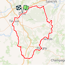
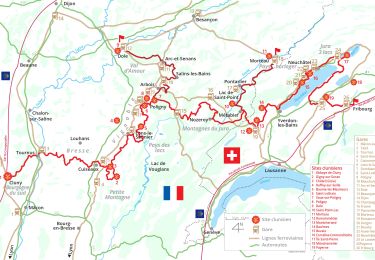
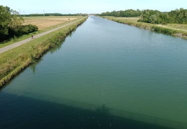
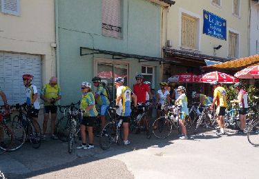
Informations techniques : 155 km en voies vertes et routes partagées (trafic maîtrisé) / Peu de dénivelé (870 mètres) / Signalétique spécifique (juillet 2013) Départ : Dole. D’autres possibilités de départ : (Arbois, Poligny, Aire du Jura, Chaussin…) Accès : TGV, train, autoroute (A39), aéroport (Tavaux) Descriptif : Le Tour du Jura à vélo version loisirs est un itinéraire vélo, accessible à tous, de 150 km, à faire sur plusieurs jours. Il emprunte des tronçons de voies vertes et de vélo-routes ainsi que de petites routes partagées mais peu fréquentés. Sur ce parcours, vous partirez à la découverte du Pays de Dole, de la Bresse Jurassienne et du Vignoble du Revermont, où la richesse du patrimoine et la beauté des paysages se mêlent à des rencontres inattendues qui vous laisseront des souvenirs inoubliables… Plus d’informations surle site du Jura.
Plaatsbepaling
Opmerkingen
Wandeltochten in de omgeving
![Tocht Stappen Jouhe - Mont Roland 11.7km 20161215 - Photo](https://media.geolcdn.com/t/375/260/ext.jpg?maxdim=2&url=https%3A%2F%2Fstatic1.geolcdn.com%2Fsiteimages%2Fupload%2Ffiles%2F1553511878bg_sport_marche.png)
![Stappen Stappen](https://static1.geolcdn.com/sitytour/trail-icons/101.png)
Stappen
![](/images/other/stat-length.png)
![](https://static1.geolcdn.com/siteimages/upload/files/16400158638029165_repeat_loop_refresh_sync_direction_icon.png)
![Tocht Stappen Dole - Dole ville - Photo](https://media.geolcdn.com/t/375/260/e28aad6a-c7e5-401c-94fb-452df6c86b47.jpg&format=jpg&maxdim=2)
![Stappen Stappen](https://static1.geolcdn.com/sitytour/trail-icons/101.png)
![Tocht Stappen Dole - Via Cluny: de Dole (Jura) à Cluny - Photo](https://media.geolcdn.com/t/375/260/1092a6f8-d0c7-4e5e-a178-164a2812cb66.jpg&format=jpg&maxdim=2)
![Stappen Stappen](https://static1.geolcdn.com/sitytour/trail-icons/101.png)
Stappen
![](/images/other/stat-length.png)
![](https://static1.geolcdn.com/siteimages/upload/files/16400158638029165_repeat_loop_refresh_sync_direction_icon.png)
![Tocht Wegfiets Dole - mn05 - Photo](https://media.geolcdn.com/t/375/260/5ece753a-d519-46d1-b96a-31a274298d2e.jpg&format=jpg&maxdim=2)
![Wegfiets Wegfiets](https://static1.geolcdn.com/sitytour/trail-icons/201.png)
Wegfiets
![](/images/other/stat-length.png)
![](https://static1.geolcdn.com/siteimages/upload/files/16400158638029165_repeat_loop_refresh_sync_direction_icon.png)
![Tocht Stappen Dole - muguet confinement - Photo](https://media.geolcdn.com/t/375/260/574ce2bd-ddb7-4098-9610-087d7bd33043.jpg&format=jpg&maxdim=2)
![Stappen Stappen](https://static1.geolcdn.com/sitytour/trail-icons/101.png)
Stappen
![](/images/other/stat-length.png)
![](https://static1.geolcdn.com/siteimages/upload/files/16400158638029165_repeat_loop_refresh_sync_direction_icon.png)
![Tocht Stappen Jouhe - g)Etapa 7 - Photo](https://media.geolcdn.com/t/375/260/ext.jpg?maxdim=2&url=https%3A%2F%2Fservices.sitytrail.com%2FGeolivesWS%2FDownloadMedia.ashx%3FTrailID%3D711082%26Media%3D20170306151955.jpg)
![Stappen Stappen](https://static1.geolcdn.com/sitytour/trail-icons/101.png)
Stappen
![](/images/other/stat-length.png)
![](https://static1.geolcdn.com/siteimages/upload/files/16400158638029165_repeat_loop_refresh_sync_direction_icon.png)
![Tocht Stappen Dole - Sentier des chênes rouges - Photo](https://media.geolcdn.com/t/375/260/ext.jpg?maxdim=2&url=https%3A%2F%2Fservices.sitytrail.com%2FGeolivesWS%2FDownloadMedia.ashx%3FTrailID%3D476404%26Media%3Dfix__20150927175830.jpg)
![Stappen Stappen](https://static1.geolcdn.com/sitytour/trail-icons/101.png)
Stappen
![](/images/other/stat-length.png)
![](https://static1.geolcdn.com/siteimages/upload/files/16400158638029165_repeat_loop_refresh_sync_direction_icon.png)
![Tocht Fiets Dole - Bletterans - Photo](https://media.geolcdn.com/t/375/260/ext.jpg?maxdim=2&url=https%3A%2F%2Fservices.sitytrail.com%2FGeolivesWS%2FDownloadMedia.ashx%3FTrailID%3D466291%26Media%3Dfix__20150828142451.jpg)
![Fiets Fiets](https://static1.geolcdn.com/sitytour/trail-icons/200.png)
Fiets
![](/images/other/stat-length.png)
![](https://static1.geolcdn.com/siteimages/upload/files/16400158638029165_repeat_loop_refresh_sync_direction_icon.png)
![Tocht Noords wandelen Jouhe - Circuit Mont-Roland - Photo](https://media.geolcdn.com/t/375/260/ext.jpg?maxdim=2&url=https%3A%2F%2Fservices.sitytrail.com%2FGeolivesWS%2FDownloadMedia.ashx%3FTrailID%3D344188%26Media%3Dfix__20140911154422.jpg)
![Noords wandelen Noords wandelen](https://static1.geolcdn.com/sitytour/trail-icons/102.png)
Noords wandelen
![](/images/other/stat-length.png)
![](https://static1.geolcdn.com/siteimages/upload/files/16400158638029165_repeat_loop_refresh_sync_direction_icon.png)