Tocht Mountainbike Voulangis - Boucle VTT Voulangis - Esbly - Quincy - Photo

Boucle VTT Voulangis - Esbly - Quincy

 tracegps
tracegps

Gebruiker

© OpenStreetMap contributors
Lengte
Lengte
54 km
Max. hoogte
Max. hoogte
138 m
Positief hoogteverschil
1072 m
Km-Effort
Km-Effort  
68 km
Min. hoogte
Min. hoogte
43 m
Negatief hoogteverschil
1075 m
Boucle
Boucle
Ja
Datum van aanmaak :
2014-12-10 00:00:00.0
Laatste wijziging :
2014-12-10 00:00:00.0

(0 Bericht)

Mountainbike
Mountainbike
4h19
Moeilijkheid : Moeilijk

Scan deze QR-code om de tocht te openen in de SityTrail-applicatie

Gratisgps-wandelapplicatie

Logo SityTrail SityTrail

IGN / Geografische instituten

SityTrail uit de App Store downloaden SityTrail uit Google Play downloaden

Logo SityTrail SityTrail World

De wereld gaat voor u open

SityTrail uit de App Store downloaden SityTrail uit Google Play downloaden SityTrail op Huawei AppGallery downloaden

Over ons

Tocht Mountainbike van 54 km beschikbaar op Île-de-France, Seine-et-Marne, Voulangis. Deze tocht wordt voorgesteld door tracegps.

Beschrijving

Belle boucle avec quelques bonnes côtes. Rando à éviter par temps trop gras.

Hoogteprofiel

Foto's

Plaatsbepaling

Land:
France
Regio :
Île-de-France
Departement/Provincie :
Seine-et-Marne
Gemeente :
Voulangis
Locatie:
Unknown
Vertrek:(Dec)
Vertrek:(UTM)
491762 ; 5410755 (31U) N.

Wandeltochten in de omgeving

Tocht Stappen Crécy-la-Chapelle - Boucle 28 km autour de Crecy la Chapelle - Guérard - Voulangis - Tigeaux - Photo
Stappen
GUIDE
chessyca

Stappen

Medium
Crécy-la-Chapelle, Île-de-France, Seine-et-Marne, France
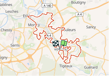
28 km | 35 km-effort
5h 46min
Ja
Tocht Stappen Crécy-la-Chapelle - Crécy la Chapelle Parcours normal - Photo
Stappen
CC.RIDER

Stappen

Gemakkelijk
(1)
Crécy-la-Chapelle, Île-de-France, Seine-et-Marne, France
16,1 km | 19,5 km-effort
4h 18min
Ja
Tocht Stappen Crécy-la-Chapelle - Crécy la chapelle - Photo
Stappen
CC.RIDER

Stappen

Gemakkelijk
(2)
Crécy-la-Chapelle, Île-de-France, Seine-et-Marne, France
19,7 km | 24 km-effort
5h 12min
Ja
Tocht Stappen Crécy-la-Chapelle - Crécy la Chapelle - Photo
Stappen
jctinchebray

Stappen

Medium
(1)
Crécy-la-Chapelle, Île-de-France, Seine-et-Marne, France
16,4 km | 20 km-effort
4h 23min
Ja
Tocht Stappen Crécy-la-Chapelle - Autour de Tigeaux - Photo
Stappen
em77

Stappen

Medium
(2)
Crécy-la-Chapelle, Île-de-France, Seine-et-Marne, France
13,2 km | 16,5 km-effort
2h 37min
Ja
Tocht Stappen Voulangis - Voulangis - Crécy - Villiers lqqm - Photo
Stappen
Tournan

Stappen

Moeilijk
(1)
Voulangis, Île-de-France, Seine-et-Marne, France
12,9 km | 15,7 km-effort
3h 34min
Ja
Tocht Stappen Voulangis - Voulangis - Crécy - Villiers - Photo
Stappen
Tournan

Stappen

Moeilijk
(1)
Voulangis, Île-de-France, Seine-et-Marne, France
12,9 km | 15,7 km-effort
3h 34min
Ja
Tocht Stappen Tigeaux - Tigeaux - Photo
Stappen
Tournan

Stappen

Medium
(1)
Tigeaux, Île-de-France, Seine-et-Marne, France
19,1 km | 24 km-effort
5h 24min
Ja
Tocht Stappen Crécy-la-Chapelle - Les coteaux du Grand Morin - Photo
Stappen
Bntg

Stappen

Medium
Crécy-la-Chapelle, Île-de-France, Seine-et-Marne, France
11,8 km | 14,3 km-effort
3h 6min
Ja


Sluiten
Mijn abonnementen