![](/images/other/stat-length.png)
![Tocht Stappen Circourt - Circuit de Circourt - Photo](https://media.geolcdn.com/t/1900/400/ext.pjpeg?maxdim=2&url=https%3A%2F%2Fservices.sitytrail.com%2FGeolivesWS%2FDownloadMedia.ashx%3FTrailID%3D214909%26Media%3D15470_1.jpg)
Circuit de Circourt
tracegps
Gebruiker
![Lengte](/images/other/stat-length.png)
Lengte
5,8 km
![Max. hoogte](https://static1.geolcdn.com/siteimages/upload/files/1508320355ic_sort_altitude_max_24dp.png)
Max. hoogte
430 m
![Positief hoogteverschil](https://static1.geolcdn.com/siteimages/upload/files/1508320355ic_sort_den_pos_24dp.png)
Positief hoogteverschil
143 m
![Km-Effort](/images/other/stat-length.png)
Km-Effort
7,7 km
![Min. hoogte](https://static1.geolcdn.com/siteimages/upload/files/1508320355ic_sort_altitude_min_24dp.png)
Min. hoogte
318 m
![Negatief hoogteverschil](https://static1.geolcdn.com/siteimages/upload/files/1508320355ic_sort_den_neg_24dp.png)
Negatief hoogteverschil
140 m
![Boucle](https://static1.geolcdn.com/siteimages/upload/files/16400158638029165_repeat_loop_refresh_sync_direction_icon.png)
Boucle
Ja
Datum van aanmaak :
2014-12-10 00:00:00.0
Laatste wijziging :
2014-12-10 00:00:00.0
![Stappen](https://static1.geolcdn.com/sitytour/trail-icons/101.png)
1h00
Moeilijkheid : Gemakkelijk
![Scan deze QR-code om de tocht te openen in de SityTrail-applicatie](https://capi.geolives.com/qq0zvz2zws4bq2lad0pu/sitytour/trails/214909/qr.png?size=200)
Gratisgps-wandelapplicatie
Over ons
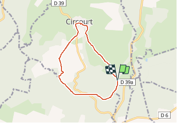
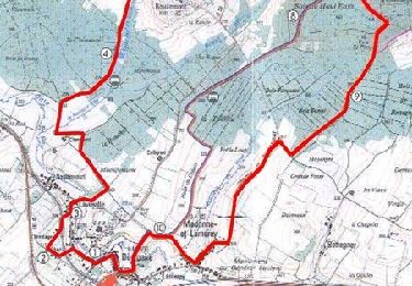
Tocht Stappen van 5,8 km beschikbaar op Grand Est, Vogezen, Circourt. Deze tocht wordt voorgesteld door tracegps.
Beschrijving
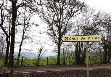
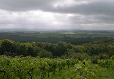
Petite boucle de 6 km autour des Bois de Revaux partant du village de Circourt. Au fil des kilomètres, découvrez les richesses géologiques et botaniques des contreforts vosgiens.
Plaatsbepaling
Land:
France
Regio :
Grand Est
Departement/Provincie :
Vogezen
Gemeente :
Circourt
Locatie:
Unknown
Vertrek:(Dec)
Vertrek:(UTM)
299317 ; 5346550 (32U) N.
Opmerkingen
Wandeltochten in de omgeving
![Tocht Te voet Bouxières-aux-Bois - Circuit des Fontaines et Lavoirs - Photo](https://media.geolcdn.com/t/375/260/ext.jpg?maxdim=2&url=https%3A%2F%2Fmedia.geolcdn.com%2Ff%2F98c0024e-3c4c-4425-b311-08f6456cc350.jpeg)
![Te voet Te voet](https://static1.geolcdn.com/sitytour/trail-icons/100.png)
Circuit des Fontaines et Lavoirs
Te voet
Gemakkelijk
Bouxières-aux-Bois,
Grand Est,
Vogezen,
France
![](/images/other/stat-length.png)
15 km | 18,8 km-effort
4h 15min
![](https://static1.geolcdn.com/siteimages/upload/files/16400158638029165_repeat_loop_refresh_sync_direction_icon.png)
Ja
![Tocht Te voet Derbamont - Circuit des Deux Vallons - Photo](https://media.geolcdn.com/t/375/260/ext.jpg?maxdim=2&url=https%3A%2F%2Fmedia.geolcdn.com%2Ff%2F98c0024e-3c4c-4425-b311-08f6456cc350.jpeg)
![Te voet Te voet](https://static1.geolcdn.com/sitytour/trail-icons/100.png)
Circuit des Deux Vallons
Te voet
Gemakkelijk
Derbamont,
Grand Est,
Vogezen,
France
![](/images/other/stat-length.png)
12,3 km | 15,8 km-effort
3h 36min
![](https://static1.geolcdn.com/siteimages/upload/files/16400158638029165_repeat_loop_refresh_sync_direction_icon.png)
Ja
![Tocht Stappen Circourt - Circourt - Photo](https://media.geolcdn.com/t/375/260/ext.jpg?maxdim=2&url=https%3A%2F%2Fmedia.geolcdn.com%2Ff%2F8213ef10-4df2-4aac-8015-08ff03318daf.jpg)
![Stappen Stappen](https://static1.geolcdn.com/sitytour/trail-icons/101.png)
![Tocht Stappen Bouxières-aux-Bois - Bouxieres-aux-bois : Le circuit de Virine - Photo](https://media.geolcdn.com/t/375/260/ext.jpg?maxdim=2&url=https%3A%2F%2Fmedia.geolcdn.com%2Ff%2F8a731d1a-c02c-4196-b810-b96986dc77ff.jpg)
![Stappen Stappen](https://static1.geolcdn.com/sitytour/trail-icons/101.png)
Bouxieres-aux-bois : Le circuit de Virine
Stappen
Heel gemakkelijk
Bouxières-aux-Bois,
Grand Est,
Vogezen,
France
![](/images/other/stat-length.png)
14,2 km | 18,3 km-effort
5h 7min
![](https://static1.geolcdn.com/siteimages/upload/files/16400158638029165_repeat_loop_refresh_sync_direction_icon.png)
Ja
![Tocht Stappen Mazeley - chanot - Photo](https://media.geolcdn.com/t/375/260/ext.jpg?maxdim=2&url=https%3A%2F%2Fmedia.geolcdn.com%2Ff%2F445e4be9-6959-4082-b6d7-fa76f69bc9a7.jpg)
![Stappen Stappen](https://static1.geolcdn.com/sitytour/trail-icons/101.png)
![Tocht Stappen Bouzemont - Circuit de Bouzemont - Dompaire - Photo](https://media.geolcdn.com/t/375/260/ext.jpg?maxdim=2&url=https%3A%2F%2Fservices.sitytrail.com%2FGeolivesWS%2FDownloadMedia.ashx%3FTrailID%3D214957%26Media%3D15524_2.jpg)
![Stappen Stappen](https://static1.geolcdn.com/sitytour/trail-icons/101.png)
Circuit de Bouzemont - Dompaire
Stappen
Moeilijk
Bouzemont,
Grand Est,
Vogezen,
France
![](/images/other/stat-length.png)
14 km | 17,2 km-effort
3h 30min
![](https://static1.geolcdn.com/siteimages/upload/files/16400158638029165_repeat_loop_refresh_sync_direction_icon.png)
Ja
![Tocht Stappen Circourt - Circuit de Virine - Circourt - Photo](https://media.geolcdn.com/t/375/260/ext.jpg?maxdim=2&url=https%3A%2F%2Fservices.sitytrail.com%2FGeolivesWS%2FDownloadMedia.ashx%3FTrailID%3D214914%26Media%3D15480_1.jpg)
![Stappen Stappen](https://static1.geolcdn.com/sitytour/trail-icons/101.png)
Circuit de Virine - Circourt
Stappen
Medium
Circourt,
Grand Est,
Vogezen,
France
![](/images/other/stat-length.png)
13,6 km | 17,6 km-effort
3h 0min
![](https://static1.geolcdn.com/siteimages/upload/files/16400158638029165_repeat_loop_refresh_sync_direction_icon.png)
Ja
![Tocht Stappen Bouzemont - Circuit de la Madonne et Lamerey - Photo](https://media.geolcdn.com/t/375/260/ext.jpg?maxdim=2&url=https%3A%2F%2Fservices.sitytrail.com%2FGeolivesWS%2FDownloadMedia.ashx%3FTrailID%3D214907%26Media%3D15466_1.jpg)
![Stappen Stappen](https://static1.geolcdn.com/sitytour/trail-icons/101.png)
Circuit de la Madonne et Lamerey
Stappen
Gemakkelijk
Bouzemont,
Grand Est,
Vogezen,
France
![](/images/other/stat-length.png)
9,5 km | 11,9 km-effort
1h 19min
![](https://static1.geolcdn.com/siteimages/upload/files/16400158638029165_repeat_loop_refresh_sync_direction_icon.png)
Ja
![Tocht Stappen Derbamont - derbamont - Photo](https://media.geolcdn.com/t/375/260/ext.jpg?maxdim=2&url=https%3A%2F%2Fmedia.geolcdn.com%2Ff%2Fb5726a75-3f97-4612-89be-d99d03b4294f.jpg)
![Stappen Stappen](https://static1.geolcdn.com/sitytour/trail-icons/101.png)