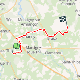
![](/images/other/stat-length.png)
![Tocht Stappen Vic-sous-Thil - Marche Expérimentale Légion VIII Augusta - Château de Thil - Château de Ste Colombe - Photo](https://media.geolcdn.com/t/1900/400/ext.pjpeg?maxdim=2&url=https%3A%2F%2Fservices.sitytrail.com%2FGeolivesWS%2FDownloadMedia.ashx%3FTrailID%3D214883%26Media%3D15430_3.jpg)
Marche Expérimentale Légion VIII Augusta - Château de Thil - Château de Ste Colombe
tracegps
Gebruiker
![Lengte](/images/other/stat-length.png)
![Max. hoogte](https://static1.geolcdn.com/siteimages/upload/files/1508320355ic_sort_altitude_max_24dp.png)
![Positief hoogteverschil](https://static1.geolcdn.com/siteimages/upload/files/1508320355ic_sort_den_pos_24dp.png)
![Km-Effort](/images/other/stat-length.png)
![Min. hoogte](https://static1.geolcdn.com/siteimages/upload/files/1508320355ic_sort_altitude_min_24dp.png)
![Negatief hoogteverschil](https://static1.geolcdn.com/siteimages/upload/files/1508320355ic_sort_den_neg_24dp.png)
![Boucle](https://static1.geolcdn.com/siteimages/upload/files/16400158638029165_repeat_loop_refresh_sync_direction_icon.png)
![Stappen](https://static1.geolcdn.com/sitytour/trail-icons/101.png)
4h00
Moeilijkheid : Moeilijk
![Scan deze QR-code om de tocht te openen in de SityTrail-applicatie](https://capi.geolives.com/qq0zvz2zws4bq2lad0pu/sitytour/trails/214883/qr.png?size=200)
Gratisgps-wandelapplicatie
Over ons
Tocht Stappen van 16,4 km beschikbaar op Bourgondië-Franche-Comté, Côte-d'Or, Vic-sous-Thil. Deze tocht wordt voorgesteld door tracegps.
Beschrijving
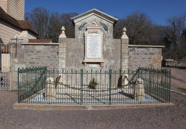
En 52 avant J.C., après le siège d'Alésia, un général de Jules César et vétéran romain nommé Flavinius, se voit offrir une terre, formée d’une colline où sera bâtie peu après la cité de Flavianiacum, aujourd’hui Flavigny-sur-Ozerain. Alésia est un oppidum gaulois de la tribu des Mandubiens, dont le nom est basé sur la racine « ales » signifiant précisément escarpement, falaise. Alésia a été le théâtre de la bataille décisive de la Guerre des Gaules qui opposa Jules César à la coalition gauloise menée Vercingétorix en 52 av. J.-C..
Plaatsbepaling
Opmerkingen
Wandeltochten in de omgeving
![Tocht Te voet Vic-sous-Thil - Les Trois Buttes - Photo](https://media.geolcdn.com/t/375/260/d697b441-ed0e-4bb7-9848-9caf418d2cb7.jpeg&format=jpg&maxdim=2)
![Te voet Te voet](https://static1.geolcdn.com/sitytour/trail-icons/100.png)
Te voet
![](/images/other/stat-length.png)
![](https://static1.geolcdn.com/siteimages/upload/files/16400158638029165_repeat_loop_refresh_sync_direction_icon.png)
![Tocht Te voet Vic-sous-Thil - En Galafre - Photo](https://media.geolcdn.com/t/375/260/d24db1bc-de3f-42e1-9464-f1c619bfc440.jpeg&format=jpg&maxdim=2)
![Te voet Te voet](https://static1.geolcdn.com/sitytour/trail-icons/100.png)
Te voet
![](/images/other/stat-length.png)
![](https://static1.geolcdn.com/siteimages/upload/files/16400158638029165_repeat_loop_refresh_sync_direction_icon.png)
![Tocht Te voet Précy-sous-Thil - La Ferme du Hameau 8 km - Photo](https://media.geolcdn.com/t/375/260/38c76b58-27bf-44f2-9412-cbed88912313.jpeg&format=jpg&maxdim=2)
![Te voet Te voet](https://static1.geolcdn.com/sitytour/trail-icons/100.png)
Te voet
![](/images/other/stat-length.png)
![](https://static1.geolcdn.com/siteimages/upload/files/16400158638029165_repeat_loop_refresh_sync_direction_icon.png)
![Tocht Te voet Précy-sous-Thil - La Ferme du Hameau 12 km - Photo](https://media.geolcdn.com/t/375/260/1108c1bb-d899-48e1-b2a1-c36a1ddb3d6b.jpeg&format=jpg&maxdim=2)
![Te voet Te voet](https://static1.geolcdn.com/sitytour/trail-icons/100.png)
Te voet
![](/images/other/stat-length.png)
![](https://static1.geolcdn.com/siteimages/upload/files/16400158638029165_repeat_loop_refresh_sync_direction_icon.png)
![Tocht Stappen Vic-sous-Thil - tilf - Photo](https://media.geolcdn.com/t/375/260/2384d343-b855-468b-832a-642844e2a116.jpg&format=jpg&maxdim=2)
![Stappen Stappen](https://static1.geolcdn.com/sitytour/trail-icons/101.png)
Stappen
![](/images/other/stat-length.png)
![](https://static1.geolcdn.com/siteimages/upload/files/16400158638029165_repeat_loop_refresh_sync_direction_icon.png)
![Tocht Mountainbike Précy-sous-Thil - butte de thil - Photo](https://media.geolcdn.com/t/375/260/ext.jpg?maxdim=2&url=https%3A%2F%2Fservices.sitytrail.com%2FGeolivesWS%2FDownloadMedia.ashx%3FTrailID%3D1023769%26Media%3Dfix__20180817180650.jpg)
![Mountainbike Mountainbike](https://static1.geolcdn.com/sitytour/trail-icons/202.png)
Mountainbike
![](/images/other/stat-length.png)
![](https://static1.geolcdn.com/siteimages/upload/files/16400158638029165_repeat_loop_refresh_sync_direction_icon.png)
![Tocht Stappen Vic-sous-Thil - w-frankrijk-vic-sous-thil-morvan - Photo](https://media.geolcdn.com/t/375/260/ext.jpg?maxdim=2&url=https%3A%2F%2Fstatic1.geolcdn.com%2Fsiteimages%2Fupload%2Ffiles%2F1553511878bg_sport_marche.png)
![Stappen Stappen](https://static1.geolcdn.com/sitytour/trail-icons/101.png)
Stappen
![](/images/other/stat-length.png)
![](https://static1.geolcdn.com/siteimages/upload/files/16400158638029165_repeat_loop_refresh_sync_direction_icon.png)
![Tocht Hybride fiets Brianny - Etape 3 : Brianny à Pouilly en Auxois - Photo](https://media.geolcdn.com/t/375/260/ext.jpg?maxdim=2&url=https%3A%2F%2Fstatic1.geolcdn.com%2Fsiteimages%2Fupload%2Ffiles%2F1524743154velo.jpg)
![Hybride fiets Hybride fiets](https://static1.geolcdn.com/sitytour/trail-icons/203.png)
Hybride fiets
![](/images/other/stat-length.png)
![](https://static1.geolcdn.com/siteimages/upload/files/16400158638029165_repeat_loop_refresh_sync_direction_icon.png)
![Tocht Fietstoerisme Fontangy - Fontagy château > verney les laumes - Photo](https://media.geolcdn.com/t/375/260/ext.jpg?maxdim=2&url=https%3A%2F%2Fstatic1.geolcdn.com%2Fsiteimages%2Fupload%2Ffiles%2F1524743154velo.jpg)
![Fietstoerisme Fietstoerisme](https://static1.geolcdn.com/sitytour/trail-icons/204.png)
Fietstoerisme
![](/images/other/stat-length.png)
![](https://static1.geolcdn.com/siteimages/upload/files/16400158638029165_repeat_loop_refresh_sync_direction_icon.png)