![](/images/other/stat-length.png)
![Tocht Noords wandelen Eijsden-Margraten - Ulvend Korte wandeling - Photo](https://media.geolcdn.com/t/1900/400/ext.pjpeg?maxdim=2&url=https%3A%2F%2Fservices.sitytrail.com%2FGeolivesWS%2FDownloadMedia.ashx%3FTrailID%3D214778%26Media%3D20130711134250.jpg)
Ulvend Korte wandeling
jos.wessels
Gebruiker
![Lengte](/images/other/stat-length.png)
Lengte
4,6 km
![Max. hoogte](https://static1.geolcdn.com/siteimages/upload/files/1508320355ic_sort_altitude_max_24dp.png)
Max. hoogte
239 m
![Positief hoogteverschil](https://static1.geolcdn.com/siteimages/upload/files/1508320355ic_sort_den_pos_24dp.png)
Positief hoogteverschil
75 m
![Km-Effort](/images/other/stat-length.png)
Km-Effort
5,6 km
![Min. hoogte](https://static1.geolcdn.com/siteimages/upload/files/1508320355ic_sort_altitude_min_24dp.png)
Min. hoogte
165 m
![Negatief hoogteverschil](https://static1.geolcdn.com/siteimages/upload/files/1508320355ic_sort_den_neg_24dp.png)
Negatief hoogteverschil
74 m
![Boucle](https://static1.geolcdn.com/siteimages/upload/files/16400158638029165_repeat_loop_refresh_sync_direction_icon.png)
Boucle
Ja
Datum van aanmaak :
2014-12-10 00:00:00.0
Laatste wijziging :
2014-12-10 00:00:00.0
![Noords wandelen](https://static1.geolcdn.com/sitytour/trail-icons/102.png)
1h45
Moeilijkheid : Gemakkelijk
![Scan deze QR-code om de tocht te openen in de SityTrail-applicatie](https://capi.geolives.com/qq0zvz2zws4bq2lad0pu/sitytour/trails/214778/qr.png?size=200)
Gratisgps-wandelapplicatie
Over ons
Tocht Noords wandelen van 4,6 km beschikbaar op Limburg, Onbekend, Eijsden-Margraten. Deze tocht wordt voorgesteld door jos.wessels.
Beschrijving
Korte wandeling door het mooie Limburgse land. Na afloop ijs eten bij Het Bakhuis in Ulvend. In de zomer echt aan te bevelen.
Plaatsbepaling
Land:
Netherlands
Regio :
Limburg
Departement/Provincie :
Onbekend
Gemeente :
Eijsden-Margraten
Locatie:
Unknown
Vertrek:(Dec)
Vertrek:(UTM)
699599 ; 5626813 (31U) N.
Opmerkingen
Wandeltochten in de omgeving
![Tocht Stappen Eijsden-Margraten - Mheer - Banholt - Hoogbos - Photo](https://media.geolcdn.com/t/375/260/1f70cdf1-9a0b-4d25-acc7-7c75993bbb86.jpg&format=jpg&maxdim=2)
![Stappen Stappen](https://static1.geolcdn.com/sitytour/trail-icons/101.png)
Mheer - Banholt - Hoogbos
Stappen
Medium
(1)
Eijsden-Margraten,
Limburg,
Onbekend,
Netherlands
![](/images/other/stat-length.png)
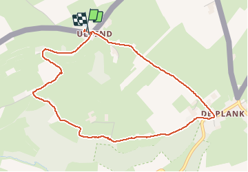
12,5 km | 14,5 km-effort
3h 4min
![](https://static1.geolcdn.com/siteimages/upload/files/16400158638029165_repeat_loop_refresh_sync_direction_icon.png)
Ja
![Tocht Stappen Voeren - Amstel Gold Race 2024 🚲 - Photo](https://media.geolcdn.com/t/375/260/bca146f7-0c03-4970-a3ca-ea328283e994.jpg&format=jpg&maxdim=2)
![Stappen Stappen](https://static1.geolcdn.com/sitytour/trail-icons/101.png)
Amstel Gold Race 2024 🚲
Stappen
Medium
(1)
Voeren,
Vlaanderen,
Limburg,
Belgium
![](/images/other/stat-length.png)
11,7 km | 14,9 km-effort
3h 23min
![](https://static1.geolcdn.com/siteimages/upload/files/16400158638029165_repeat_loop_refresh_sync_direction_icon.png)
Ja
![Tocht Stappen Voeren - Ulvend - La Planck - Noorbeek - Photo](https://media.geolcdn.com/t/375/260/1b8a3af4-c436-4943-b8e2-3197209c6144.jpg&format=jpg&maxdim=2)
![Stappen Stappen](https://static1.geolcdn.com/sitytour/trail-icons/101.png)
Ulvend - La Planck - Noorbeek
Stappen
Gemakkelijk
(1)
Voeren,
Vlaanderen,
Limburg,
Belgium
![](/images/other/stat-length.png)
17 km | 22 km-effort
4h 57min
![](https://static1.geolcdn.com/siteimages/upload/files/16400158638029165_repeat_loop_refresh_sync_direction_icon.png)
Ja
![Tocht Stappen Voeren - 2022-11-11_17h35m36_wandelroute-de-voerstreek-mooiste - Photo](https://media.geolcdn.com/t/375/260/3df743f8-88e4-4c10-a47a-c05fdf0072fe.jpg&format=jpg&maxdim=2)
![Stappen Stappen](https://static1.geolcdn.com/sitytour/trail-icons/101.png)
2022-11-11_17h35m36_wandelroute-de-voerstreek-mooiste
Stappen
Medium
(1)
Voeren,
Vlaanderen,
Limburg,
Belgium
![](/images/other/stat-length.png)
9,3 km | 12,5 km-effort
2h 49min
![](https://static1.geolcdn.com/siteimages/upload/files/16400158638029165_repeat_loop_refresh_sync_direction_icon.png)
Ja
![Tocht Stappen Voeren - La Commanderie 7 - Photo](https://media.geolcdn.com/t/375/260/e2b67305-0779-4cca-9070-82e3402cc790.jpg&format=jpg&maxdim=2)
![Stappen Stappen](https://static1.geolcdn.com/sitytour/trail-icons/101.png)
La Commanderie 7
Stappen
Gemakkelijk
(1)
Voeren,
Vlaanderen,
Limburg,
Belgium
![](/images/other/stat-length.png)
4,5 km | 6,3 km-effort
1h 26min
![](https://static1.geolcdn.com/siteimages/upload/files/16400158638029165_repeat_loop_refresh_sync_direction_icon.png)
Ja
![Tocht Stappen Dalhem - 2021-10-21_18h00m54_1397 - Photo](https://media.geolcdn.com/t/375/260/9e5bb66b-83f0-45b1-bd6f-be4253f11322.jpg&format=jpg&maxdim=2)
![Stappen Stappen](https://static1.geolcdn.com/sitytour/trail-icons/101.png)
2021-10-21_18h00m54_1397
Stappen
Medium
(2)
Dalhem,
Wallonië,
Luik,
Belgium
![](/images/other/stat-length.png)
13,9 km | 17,6 km-effort
3h 59min
![](https://static1.geolcdn.com/siteimages/upload/files/16400158638029165_repeat_loop_refresh_sync_direction_icon.png)
Ja
![Tocht Stappen Voeren - 2021-10-13_17h01m13_fouron-le-comte - Photo](https://media.geolcdn.com/t/375/260/e05bdacf-e910-4818-b0aa-de5529cdf1e8.jpg&format=jpg&maxdim=2)
![Stappen Stappen](https://static1.geolcdn.com/sitytour/trail-icons/101.png)
2021-10-13_17h01m13_fouron-le-comte
Stappen
Gemakkelijk
(1)
Voeren,
Vlaanderen,
Limburg,
Belgium
![](/images/other/stat-length.png)
14,5 km | 16,9 km-effort
3h 50min
![](https://static1.geolcdn.com/siteimages/upload/files/16400158638029165_repeat_loop_refresh_sync_direction_icon.png)
Ja
![Tocht Stappen Eijsden-Margraten - 2021-06-19_19h26m43_031 - Photo](https://media.geolcdn.com/t/375/260/136c3226-85ca-4638-b449-da2a119d703c.jpg&format=jpg&maxdim=2)
![Stappen Stappen](https://static1.geolcdn.com/sitytour/trail-icons/101.png)
2021-06-19_19h26m43_031
Stappen
Gemakkelijk
(1)
Eijsden-Margraten,
Limburg,
Onbekend,
Netherlands
![](/images/other/stat-length.png)
13,3 km | 15,7 km-effort
3h 34min
![](https://static1.geolcdn.com/siteimages/upload/files/16400158638029165_repeat_loop_refresh_sync_direction_icon.png)
Ja
![Tocht Stappen Gulpen-Wittem - 2021-03-30_19h30m42_1141 - Photo](https://media.geolcdn.com/t/375/260/4eff2d95-7f9b-4081-a7dd-49c9945fbab4.jpg&format=jpg&maxdim=2)
![Stappen Stappen](https://static1.geolcdn.com/sitytour/trail-icons/101.png)
2021-03-30_19h30m42_1141
Stappen
Gemakkelijk
(2)
Gulpen-Wittem,
Limburg,
Onbekend,
Netherlands
![](/images/other/stat-length.png)
12,5 km | 16,1 km-effort
3h 38min
![](https://static1.geolcdn.com/siteimages/upload/files/16400158638029165_repeat_loop_refresh_sync_direction_icon.png)
Ja